


The existence of a river harbour and ford in the lowland between the Capitoline and Aventine Hills is an entrenched assumption in the scholarship on Rome's origins, reflecting what are thought to be the natural advantages of the site, positioned at a crossroads in prehistoric central Italy.Footnote 1 It is thought that early seafaring ships, which would have found a dearth of suitable harbours on the Tyrrhenian coast of Latium, could sail into the mouth of the largest river in central Italy, the Tiber, and travel fifteen miles upstream. On the east bank just south of the Tiber island — a district that came to be known as the Forum Boarium (Fig. 1) — sailors would find a convenient landing place. Similarly, overland travel north–south between Etruria and Campania and east–west between the inland mountains and coast would find a hospitable crossing point, either by ford or ferry, at this particular river bend. These topographic circumstances would have had significant implications for the growth of a city at a site seemingly poised for pan-Mediterranean trade and regional dominance. Long before all roads led to Rome, the Forum Boarium valley would have been a major thoroughfare for people and goods moving around central Italy.Footnote 2
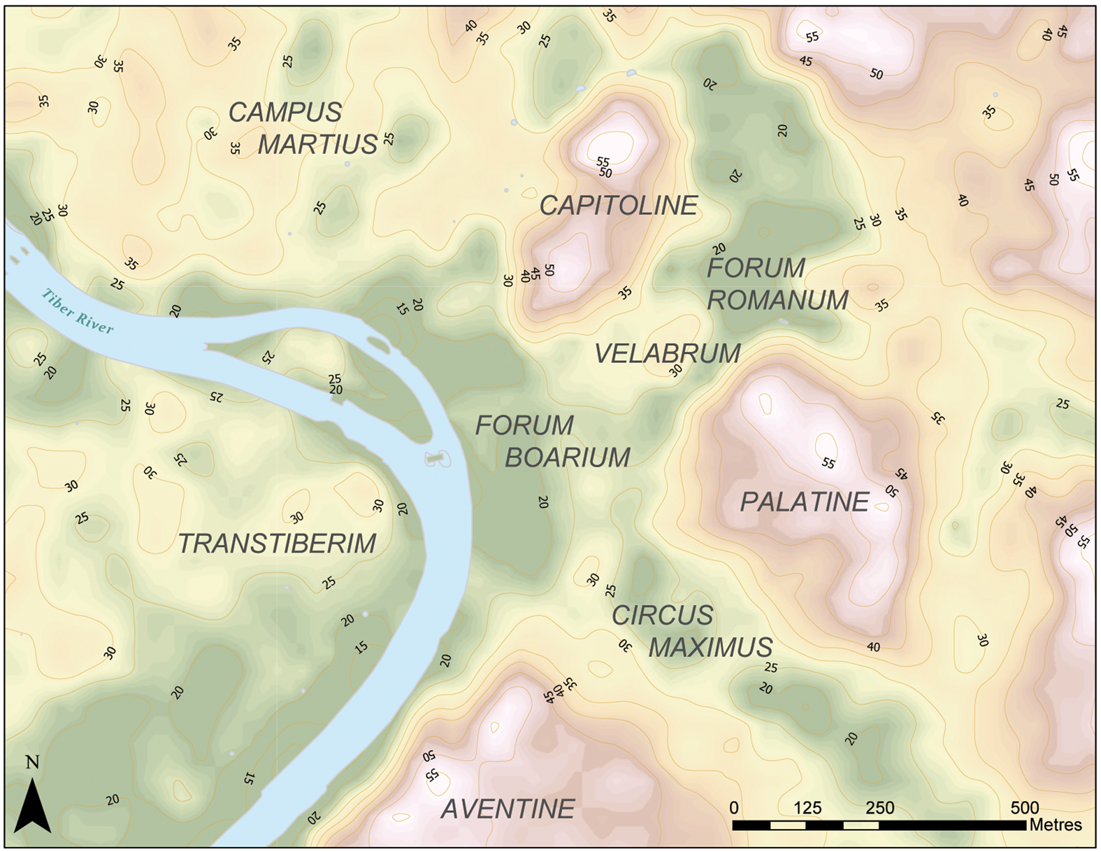
FIG. 1. Topographic map of modern Rome with the ancient names of regions of the city. (Andrea L. Brock)
This common conception of early Rome has its roots in the ancient literary record and has manifested itself in various forms in scholarship since the nineteenth century (below, Section I), but is in fact based on extremely limited direct evidence. Archaeological levels associated with Rome's prehistoric riverine activity are situated over 10 m below the modern surface, severely impeding research in the river valley. However, environmental approaches are beginning to offer a productive avenue to early Rome by revealing previously unknown topographical and ecological details. Recent geoarchaeological investigations — a deep coring survey carried out in the Forum Boarium between 2013 and 2019 — have shed substantial light on Rome's central riverbank as it existed before and changed alongside urban growth at the site.
After reviewing the state of knowledge of early activity in Rome's river valley and introducing the Forum Boarium Project, this paper makes two major advances. First, we present a new reconstruction of Rome's riverine landscape in the early sixth century b.c.e. In doing so, we provide the first empirical evidence to suggest that the particular topographic and hydrological conditions in the valley between the Capitoline and Aventine Hills would in fact have facilitated harbour and fording activity in this early period. Although we can now re-evaluate with greater certainty and in finer detail the advantages offered by Rome's natural landscape, the geoarchaeological record also makes clear that this was not a static, stable setting. Thus the second major contribution of this paper is to offer new evidence for landscape transformation, as the Tiber shifted and the river valley silted up between the sixth and third centuries b.c.e. The district of the Forum Boarium in the historical period was the product of centuries of fluvial change, followed by urbanisation of the floodplain from the mid-Republic onwards. By tracing the evolution of Rome's riverbank, it ultimately becomes clear that the mutability of the landscape compelled inhabitants to adapt their river-related activities both rapidly over a period of a few generations and progressively over the centuries.
I PREVIOUS CONCEPTIONS OF ROME'S EARLY RIVER VALLEY
Velabrum Swamp
Ancient authors demonstrate a general awareness or assumption that the Tiber river was important for the city's early development.Footnote 3 The first modern generation of Roman historians similarly emphasised Rome's strategic position along trade routes within central Italy, and the Mediterranean more broadly, as integral to the city's early success. These perceived economic opportunities relied heavily on the presumption, drawn from ancient written sources, that Rome controlled a seaport at the mouth of the Tiber from the regal period.Footnote 4 We can understand how both ancient and modern writers interested in the city's origins believed the early incorporation of Ostia to have been an absolute necessity, especially considering the ostensibly challenging landscape at the site of Rome itself.Footnote 5 Several ancient sources refer to a swamp that originally existed in the Velabrum (the valley between the Capitoline and Palatine Hills that stretches to the Tiber) and the need to use a ferry to travel between the Aventine Hill and the rest of the city.Footnote 6 This body of water at the margins of the Tiber, so the story goes, existed until the construction of the Cloaca Maxima, the city's first drainage channel.Footnote 7
Practically speaking, the marshy landscape envisaged by both ancient and modern authors would not have been conducive for harbour activity or foot traffic. For this reason, Joël Le Gall, in the first comprehensive survey of the Tiber's history, argued that the Forum Boarium was in fact a poor choice for Rome's primitive harbour.Footnote 8 According to this conception of Rome's original landscape, the lowland would require human intervention — drainage, land reclamation and the creation of a river embankment — before the river valley could have been useful to the city's early inhabitants.
Given that the ancient sources were written several centuries after the period they purport to memorialise, these accounts of Rome in the seventh and sixth centuries b.c.e. are extremely dubious. The literary record mirrors the authors’ contemporary society in various ways, and ecological conditions had changed significantly by the time the first ‘histories’ of early Rome were composed in the third century b.c.e.Footnote 9 As one of the largest cities of the pre-modern world, Rome in the historical era relied on extensive commercial port infrastructure along both riverbanks to support heavy traffic on and around the river, in addition to seaports at Puteoli on the Bay of Naples and at Ostia.Footnote 10 The riverine landscape familiar to ancient authors must therefore have been morphologically, topographically and functionally different from the prehistoric setting. Moreover, a robust documentary record makes it clear that floods of the Tiber periodically inundated the city's lowlands.Footnote 11 This recurrent hydrological challenge may explain why ancient authors imagined the city's deep past as characterised by a swampy landscape that required drainage. Nonetheless, despite the inherent problems with the literary record, modern scholars continued to presume the existence of a swamp in regal Rome for many decades, until recent geoarchaeological research dispelled it (below, Section III).Footnote 12
River Harbour
Alongside the image of a swamp in the area of the Velabrum, there is also a separate conception, which emerges in both mythical and quasi-historical accounts from the later literary record, that boats were able to land at the shore of Rome in the prehistoric era. Most famously, at a climactic moment in Book VIII of the Aeneid, Vergil described how the itinerant Trojans first came to Rome. Guided by the god Tiberinus, Aeneas and his crew rowed their boats up the river to Evander's settlement on the Palatine, where they came ashore in the vicinity of a precinct sacred to Hercules.Footnote 13 We can link this story with the Forum Boarium, where four distinct sanctuaries, including the Ara Maxima, commemorated the region's associations with Hercules.Footnote 14 Furthermore, Dionysius of Halicarnassus described how in the mid-fifth century a Sabine army ‘sailed down the Tiber river and landed at that part of Rome where the Capitolium stands not a full stade away from the river’.Footnote 15 This account may be a reference to the stretch of riverbank in the area of the Forum Boarium, or potentially to the southern edge of the Campus Martius.
By the time these accounts of an early harbour were written in the Augustan era, it is clear that the Forum Boarium district was closely associated with port activity. The first corroborating evidence for the existence of a historical port was provided by the burgeoning sub-discipline of topography in the nineteenth century. For Roman topographers striving to map the ancient city, a short passage from Varro (Ling. 6.19) became a significant crux. In a reference to the Portunalia festival, Varro mentioned the presence — at least in the first century b.c.e. — of a shrine of Portunus, the god of ports, at the Portus Tiberinus.Footnote 16 The Fasti further indicate that the Portunalia took place near the Pons Aemilius.Footnote 17 Based on these references and his reading of the Notitia, a topographic survey of Rome in the fourth century c.e., Christian Hülsen originally identified the Temple of Portunus with the Round Temple of the Forum Boarium.Footnote 18 André Piganiol preferred to attribute the nearby Ionic temple to Portunus, and drew further inferences from the supposed proximity of republican port installations mentioned by Livy.Footnote 19 In these ways, the first generation of Roman topographers closely tied the Forum Boarium and Temple of Portunus to a commercial port that existed at least from the late Republic.
These topographical inferences received archaeological corroboration from discoveries made during Fascist efforts to renew Rome, when huge swathes of the city were stripped of their medieval and early modern structures. Excavations prior to the construction of the Palazzo dell'Anagrafe revealed the first physical traces of port infrastructure in the Forum Boarium: Trajanic storage facilities (horrea).Footnote 20 Even more momentous findings were made nearby, after demolition around the Church of Sant'Omobono revealed an ancient sanctuary complex.Footnote 21 In 1937–8, Antonio M. Colini led the first excavations of the area, unearthing at great depth a scintillating collection of prehistoric materials. Discoveries included the stone podium of a very early temple building, which had been adorned with an archaic terracotta statue group of Hercules and Minerva, currently on display at the Musei Capitolini. Excavations also produced an impressive ceramic assemblage of Bronze Age, imported Greek, and Early Iron Age Etruscan wares, found mixed in secondary contexts at the Sant'Omobono sanctuary.Footnote 22
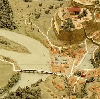
Drawing on these archaeological discoveries, mid-twentieth-century scholars began writing of a commercial port that stretched back to the prehistoric era.Footnote 23 The presence of orientalising Greek pottery, in particular, led to the conclusion that foreign trade via Rome's harbour began already in the eighth century.Footnote 24 Colini located the harbour in the vicinity of the Anagrafe building, envisioning a low bank that allowed access for boats, which was eventually covered by later port infrastructure.Footnote 25 Over the decades, many scholars have accepted and echoed such inferences about an early harbour in the Forum Boarium, with few sceptics or dissenters.Footnote 26 Some further posited that the first major investment in commercial port infrastructure at the Portus Tiberinus should be associated with the archaic temple building at Sant'Omobono and dated to the reign of Servius Tullius.Footnote 27 Although the sources do credit Servius with building a temple in the Forum Boarium, there is no mention of contemporary port infrastructure.Footnote 28 This conception of an early Portus Tiberinus manifests itself in a particularly imaginative form in Lorenzo Quilici's plastic model of the archaic city.Footnote 29 Built in 1990 for ‘La Grande Roma dei Tarquini’ exhibition and put on display at the Museo della Civiltà Romana, the model depicts a densely urbanised riverbank district, complete with permanent quays and docks set back from the river (Fig. 2). Quilici's visualisation is evocative but problematic, not only because it is based on little material or textual evidence, but also because it fails to account for some basic hydrological issues, such as seasonal flooding.
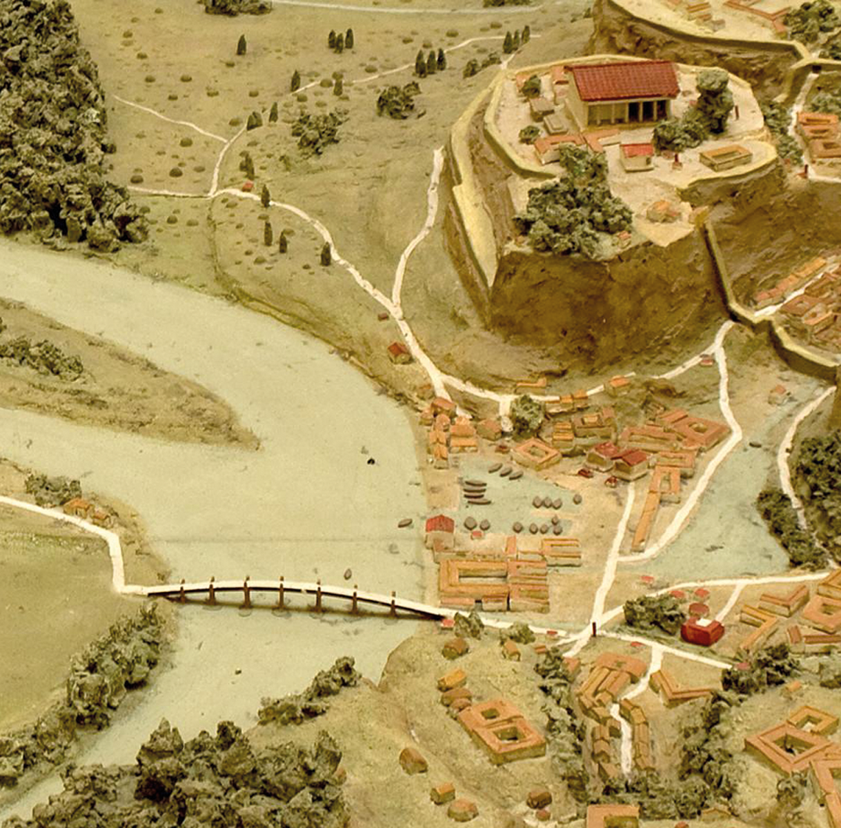
FIG. 2. Detail of Lorenzo Quilici's plastic model of archaic Rome, showing his reconstruction of the Portus Tiberinus in the region of the Forum Boarium. (Photograph: Andrea L. Brock)
Ford across the Tiber
In their seminal work of 1929, A Topographical Dictionary of Ancient Rome, Samuel B. Platner and Thomas Ashby conceived of Rome's lowland landscape much like their contemporaries: the Velabrum valley was thought to have originally been marshy, before the area was drained by the Cloaca Maxima and the riverbank eventually built up as part of the Portus Tiberinus and Temple of Portunus.Footnote 30 However, Platner and Ashby also made a further bold assumption that would go on to become ingrained in the collective scholarly mind: ‘The importance of the site of the Palatine and of Rome is mainly due to its command of the crossing of the Tiber just below the island, which must be of great antiquity, and was probably the only one in the whole lower course of the river.’Footnote 31
Indications of such a ford lie less in the ancient literary record than in Platner and Ashby's reading of Rome's urban topography. Although the myth of Hercules’ arrival at Rome includes an account of the hero shepherding his cattle across the Tiber, other clear indications of a ford at Rome are absent from the ancient literary record.Footnote 32 Dionysius, an Augustan-era historian of early Rome, outright rejected the notion that it was once possible to cross the river on foot.Footnote 33 This remark reflects his contemporary conditions: in the historical period, as today, the Tiber was typically not fordable at Rome. For Platner and Ashby, however, the location of the Pons Sublicius (Rome's oldest bridge) and the route of the Vicus Iugarius (one of Rome's oldest roads) indicated the presence of a ford at a point of slack water downstream from the Tiber island.Footnote 34 They further linked their conceptions of a river-crossing to the early exploitation of salt beds on the right bank at the mouth of the Tiber and transport along the Via Salaria through the Forum Boarium.Footnote 35
Like Platner and Ashby, many scholars have emphasised the antiquity of the salt trade and re-asserted the notion that there originally existed a ford, ferry, or generic crossing-point of the Tiber at Rome.Footnote 36 In addition to inferences drawn from the topography of the later city, the supposed position of a ford is arguably bolstered by assumptions about advantageous hydrological conditions that would have also facilitated harbour activity in the Forum Boarium. Although archaeological or environmental corroboration for the ford has hitherto been lacking, the prehistoric findings on the Capitoline Hill offer some indirect support by proving the existence of a settlement from at least the late second millennium. Indeed, Alberto Cazzella, director of the Giardino Romano excavation, suggested that these Bronze Age inhabitants of the Capitoline might have had a strong interest in the nearby river ford.Footnote 37
II FORUM BOARIUM CORING SURVEY
In sum, there has been general consensus about the existence, if not the specific details, of a harbour and ford in early Rome. Until now, however, it has been difficult to acquire direct and contemporary evidence of such features. Secure arguments about Rome's early landscape and the precise role it played in the city's development have been elusive. Obscured by the late inception of the literary record and the inaccessibility of deeply buried archaeological levels, Rome's original riverine activity — like so much else from the prehistoric era — has long been consigned to the realm of myth, speculation, or untested hypothesis.
Systematic investigation of the river valley has only been made possible by recent advancements in technology and scientific analysis. Environmental studies have begun to augment traditional views of early Rome by providing novel datasets as well as nuanced perspectives on matters of human experience and societal development. Although the adoption of ecological methods and theories has been comparatively slow in Classical Archaeology, important groundwork was laid by Albert Ammerman, who was the first to lead sub-surface geoarchaeological surveys in Rome, beginning in the 1980s. His work in the Velabrum challenged conventional conceptions of a swamp in regal Rome. He also argued that landscape modification, such as the filling of the lowland basin to establish the Forum Romanum, was a pivotal component in the creation of the city.Footnote 38 The present geoarchaeological investigation along Rome's riverbank now shows how the process of urbanisation was not a straightforward progression from untamed land to drained and reclaimed cityscape: it was far more dynamic and complex.
This project began as part of a reinvestigation of the Sant'Omobono sanctuary. As there are few gaps in the republican and imperial pavements of the site sufficiently large to permit excavation, we devised a coring campaign to survey areas that could not be excavated. Coring survey can operate at various scales, but the process is essentially the same: a metal sampling bit is drilled into the ground to recover a cylindrical sediment core, which serves as a narrow but deep slice of archaeological and geological stratigraphy. In 2013–14, we used a hand-held Cobra TT percussion drill to make eighteen boreholes across the Sant'Omobono archaeological zone. Each of these boreholes had a width of 5 cm and reached depths up to 8 m below the exposed ancient surface. In 2015 and 2019, we expanded the coring campaign beyond the limits of Sant'Omobono, in order to survey the entire region of the Forum Boarium (Fig. 3). To do so, we hired geophysical contractors who operate a larger Beretta T46 rig, capable of drilling through hard stone and concrete.Footnote 39 Each of the twenty-two mechanised boreholes made in 2015 and 2019 had a width of 8 cm, and reached a depth of 15 m or more from the modern surface.Footnote 40 In total, our investigations in the Forum Boarium resulted in a substantial amount of stratigraphic data — over 400 vertical metres with nearly 100 per cent recovery in every core (a result not obtained in previous surveys of the area).Footnote 41
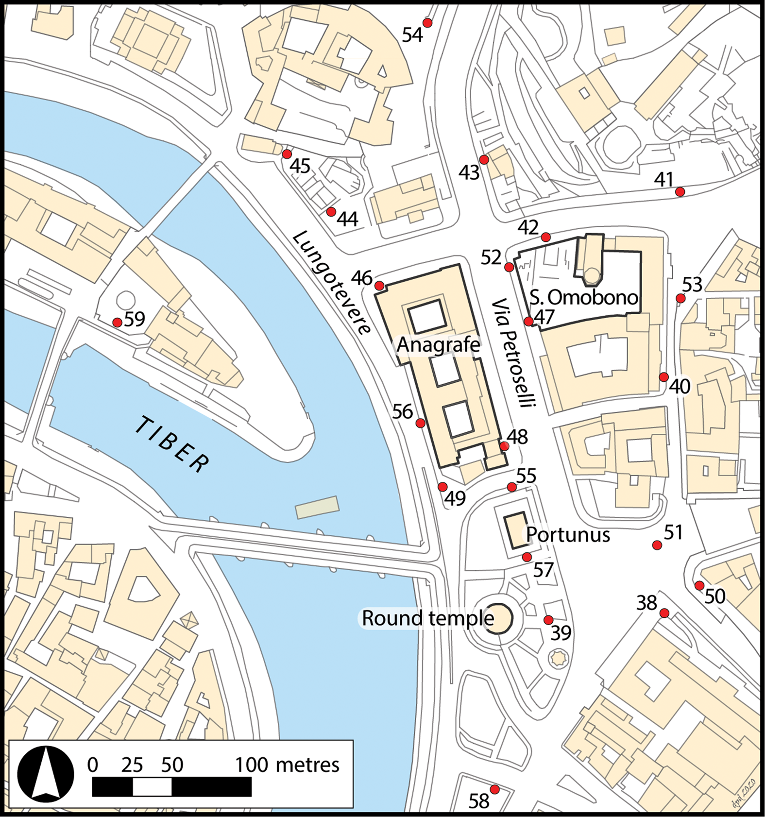
FIG. 3. Map of the modern Forum Boarium with the locations of the mechanised boreholes and relevant structures. (Daniel P. Diffendale)
After drilling the boreholes, the sediment cores were studied stratigraphically and sampled extensively.Footnote 42 Alongside macro- and micro-botanical analysis, as well as granulometric and micromorphological studies, a major priority was to identify chronological markers, in order to situate the stratigraphic record in time and space. In total, we have amassed a collection of more than 200 sherds of ancient pottery and took 45 organic samples for radiocarbon dating; our chronology stretches across the entire epoch of human settlement at Rome as well as a Holocene geological record.Footnote 43 Of particular interest is the deepest anthropic inclusion (typically a ceramic sherd) in each core, as this marks a key boundary signalling human presence on the local landscape. Although Ammerman's surveys uncovered the deepest sherds at elevations around 5 m above the modern sea level (masl),Footnote 44 our investigation revealed anthropic materials at significantly greater depths, at elevations as low as 2 m below sea level (mbsl).Footnote 45 By documenting the low base level of the river valley, we offer a far better-defined third dimension to studies of early Rome.
III ROME'S RIVER VALLEY IN THE EARLY ARCHAIC PERIOD
Excavations in other parts of Rome in recent decades have considerably increased the quantity and quality of evidence for the city's origins. A discernible shift in the archaeological record is now apparent between the late seventh and early fifth centuries b.c.e., Rome's so-called Archaic Period. While Late Bronze and Early Iron Age habitation at the site generally consisted of wattle and daub huts on the hilltops, along with small-scale terracing efforts and lowland burials,Footnote 46 the sixth century saw the introduction of monumental, stone-based, and terracotta-roofed buildings. Additionally, land modification through terracing and reclamation projects helped to convert the disjointed and uneven landscape into a more level and unified setting.Footnote 47 An increasing volume of archaeological evidence now shows that the sixth century was a pivotal phase on Rome's journey from hut settlement to city.
Drawing on discoveries made by the Forum Boarium Project, we offer here a new reconstruction of Rome's central river valley as it existed at the beginning of the sixth century, on the eve of this major urban development (Fig. 4). Thanks to this new and clearer picture of the topography and hydrology that once characterised Rome's landscape, in Section IV we are able to re-evaluate the range of human activity along the riverbank. Finally, in Section V we describe the substantial changes that occurred in this area from the sixth century onwards, since it is now apparent that Rome's river valley looked very different at the end of the Archaic Period than it had at the beginning.
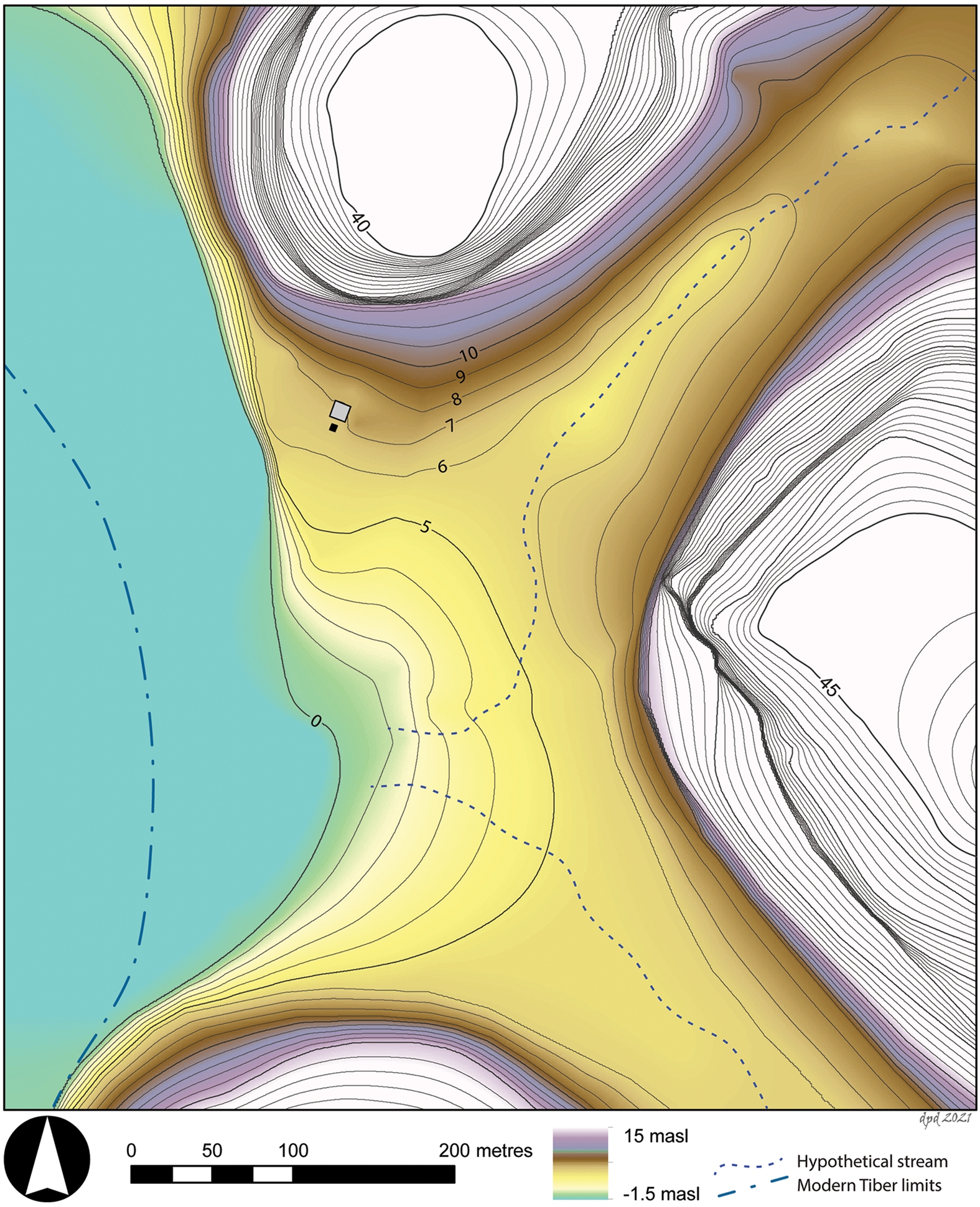
FIG. 4. Topographic reconstruction of the early archaic riverbank in the Forum Boarium, noting the position of the temple and altar from the Sant'Omobono sanctuary. (Daniel P. Diffendale)
Topography
Starting from the lowest point on the landscape, coring in the vicinity of Via Petroselli and the Lungotevere demonstrates, first, that the Tiber once flowed roughly 100 m further east than its modern course and, second, that the ancient riverbed was markedly lower than previously appreciated.Footnote 48 At elevations between roughly 0 masl and 2 mbsl, ten cores (39, 43, 47, 48, 49, 52, 55, 56, 57, and 58) revealed sands and rounded gravels, interpreted as deposits in or very near the active river channel.Footnote 49 This c. 1 mbsl stratigraphic horizon contained more than twenty ceramic sherds across the cores. These pottery fragments were not found in a primary, settlement context, but in a secondary context, having been washed or dumped into the fluvial system before ultimately settling on the valley floor. Most importantly, this collection of sherds demonstrates that the Tiber river flowed in the vicinity of Via Petroselli at least until the beginning of the Archaic Period (around the beginning of the sixth century b.c.e.).Footnote 50
At the margins of the Tiber, with its bed around 1 mbsl, boreholes have also exposed the contemporary shore. Stratigraphy from cores 38, 40, 50, 51 and 53 is consistent with near-river environments: when rivers swell and spread over their banks, floods carry and ultimately drop fine-grain sediments as waters stagnate. The silts found in this part of the valley are typical of the low-velocity deposition in floodplain environments (periodically inundated marginal zones). These findings are, therefore, consistent with the results of Albert Ammerman and Dunia Filippi's coring survey in the Velabrum. Challenging previous assumptions about a swampy formation in regal Rome (above, Section I), Ammerman and Filippi argued that the central part of the Velabrum valley was actually seasonally dry by the time people settled at the site of Rome.Footnote 51 Our cores along the riverbank further demonstrate that the lower Velabrum valley was indeed a seasonally dry floodplain in the early centuries of the first millennium b.c.e.., not an expansive body of standing water. Impasto bruno sherds (providing a vague pre-archaic terminus post quem) were found within these floodplain sediments in core 50 at extreme depths, 1 masl, indicating that the terrain north of the Aventine Hill was once quite low. Given its proximity to the active river, this area must have been a recurrently submerged shore, rather than a large, permanent swamp.
In contrast to the low-lying shore in the lower Velabrum valley, a conspicuously high section of riverbank once protruded from the southern flank of the Capitoline Hill; walking beside the river from south to north, one would originally have ascended some 6 m. Excavations and coring across the Sant'Omobono sanctuary have revealed fine-grain fluvial sediments at the base of the republican and archaic archaeological sequence. The surface sits at 7.4 masl near the Capitoline and slopes down to 6 masl along the southern limit of the Sant'Omobono sanctuary, before sloping further downwards towards the Velabrum valley. This particular zone, unlike other nearby areas, was apparently shielded from erosive forces. The existence of this elevated shelf of land may be the fortuitous product of the solid structure of the Capitoline Hill, which could well have bounded the meandering river. Coring along the western edge of the Sant'Omobono sanctuary has revealed that the ground level (at c. 6.5 masl) sloped precipitously down to the adjacent river channel (at c. 1 mbsl); this is suggestive of a steep bank created by the Tiber's erosive power. Together, these conditions indicate that in the early sixth century a prominent natural ledge was perched above the river. This important feature has not been recognised in previous scholarship, nor in the most recent morphological description of the Velabrum valley.Footnote 52
As the low-lying shore in the southern Forum Boarium was undoubtedly subjected to regular overbank flooding, it is noteworthy that flood deposits did not accumulate and aggrade the ground level in the area closer to the Aventine, as was possible in the area at the base of the Capitoline Hill. This discontinuity should be attributed to the impact of tributary streams, one entering the Tiber from the Velabrum valley and the other from the valley between the Palatine and Aventine Hills, where the Circus Maximus would eventually evolve. Although such tributary streams no longer exist today, there are compelling circumstantial clues that they once did, including the valley morphology itself and the eventual installation of drainage infrastructure.Footnote 53 These streams did not erode the land beneath Sant'Omobono, and therefore they must have entered the Tiber somewhere to the south. We have not yet determined the precise location of the creek bed. This would in any case have been ephemeral in the era before the streams were converted into canalised drains, as they would have moved across the width of their respective valleys.Footnote 54 Further confirmation for the presence of tributary streams can be broadly inferred from the cores, which have revealed compositionally and granulometrically distinct fluvial sediments: often yellowish silts and sands, attributable to the Tiber river;Footnote 55 and often greyish clays and silts, arguably deposited by a distinct, localised system, such as one or both of these tributaries.Footnote 56 The point of confluence (probably located somewhere in the southern Forum Boarium) would have been subjected to the erosive forces of all three fluvial systems, so that the ground level remained low, particularly in contrast to the adjoining section of high, uneroded riverbank.
Hydrology
Although the sedimentary record allows us to create a topographic picture, gauging past river depth is difficult. River behaviour is influenced by a highly variable mix of hydrological inputs and outputs that change on short, medium and long timescales. However, for a site-specific reconstruction, we now have key signals that shed some light on seasonal water levels in early archaic Rome. In order to estimate the depth of the river during periods of normal or low flow, we can compare the elevation disparity between deposits within or very near the riverbed and seasonally dry marginal zones on the riverbank. The base of the Tiber's channel has been identified around 1 mbsl at the beginning of the sixth century, while parts of the east bank seem to have stood as low as 1 masl.Footnote 57 Together, these data-points suggest an approximate water depth of 2 m or less in the vicinity of the Forum Boarium during the dry season.
In order to estimate the upper boundary of water depth, the high riverbank preserved beneath Sant'Omobono is a crucial indicator. Conveniently shielded from erosion and undisturbed by clean-up efforts, flood deposits here serve as a valuable physical record of the extent of flood waters. We can therefore be certain that floods in the pre-republican era reached at least 7.4 masl, suggesting that water peaked somewhere around 8 masl, equating to a depth of roughly 9 m. Although even higher floods are feasible, it is worth noting that any inundation cresting over 6 masl would spread into the Velabrum and Circus Maximus valleys.Footnote 58 These secondary basins provided substantial accommodation space, allowing water to spread laterally before continuing to rise vertically. In other words, the volume of water necessary for a flood at Rome to swell from 6 to 8 masl would have been orders of magnitude greater than that required to push waters from 4 to 6 masl.
To summarise: prior to the late sixth-century growth of the city, Rome's river valley was the unique product of local geology and hydrological forces. It is admittedly challenging to visualise this landscape, particularly given the homogeneous terrain one experiences walking around the modern Forum Boarium. However, we should imagine a far more dramatic setting at the beginning of the sixth century. The Tiber was flowing 100 m to the east of its modern course, much closer to the hills of Rome. Protruding from the side of the Capitoline Hill, a conspicuous shelf once stood some 6 m above the surface of the adjacent river. Even during periods of heavy rain, this part of the valley would have been the last to flood and first to dry. In stark contrast, the Tiber would have overflowed first and most frequently at the low section of the channel banks due south. This area was seasonally dry, but was crossed by two tributary streams as they flowed toward the Tiber. Moving inland from this low shore, the ground level ascended gradually into the Velabrum and Circus Maximus valleys.
IV ROME'S ORIGINAL RIVER HARBOUR AND FORD
Early Riverbank Activities
As we have seen, coring survey has revealed key details of Rome's river valley, indicating that the Forum Boarium was once characterised by a low-lying shore (around 1 masl) adjoining a high riverbank (around 6.5 masl) at the base of the Capitoline Hill. This setting would be particularly advantageous for river-related pursuits. Although the prehistoric activities in the river valley left few material traces, we can extrapolate from the environmental reconstruction in order to make some logical deductions.
First, this low-lying shore would have been an ideal location for animals to drink at the river. Indeed, ancient sources and generations of modern scholars have made etymological inferences about the origins of the Forum Boarium as a ‘Cattle Market’.Footnote 59 Livestock which would have had difficulty traversing the steep terrain typical of other sections of riverbank would have been able to approach the river at this particular point with far greater ease. Although we must be cautious not to extrapolate broadly from findings from a single core, a borehole drilled near the south-east corner of the Sant'Omobono sanctuary exposed an extremely rare deposit: 40 cm of animal dung, suggesting that livestock were present in the archaic Forum Boarium.Footnote 60 It is difficult to know the scale of such a ‘Cattle Market’, but the availability of suitable terrain would certainly have influenced the way livestock in early Rome were maintained and shepherded across the landscape.
Second, there is new justification for the notion of a ford at this gently sloping shore, which could aid ingress and egress, in the southern part of the Forum Boarium. However, contrary to earlier speculation, a crossing point would not necessarily have relied on slack water created by the Tiber island; it is actually possible that the island did not even exist in this era.Footnote 61 Generally speaking, it is safest to ford a river at its widest point, where waters are able to spread and dissipate. Although no sub-surface survey which could help determine the channel width has yet been carried out along the riverbank opposite the Forum Boarium, the location of the east bank indicates a broadening of the river channel (as compared to its modern course). It is therefore likely that waters were slower and shallower here compared to other stretches of the river. People — whether by wading or by riding a cart or animal — and livestock may have found this to be a safe place to cross the Tiber, although possibly only during dry seasons when the river was at its lowest levels (estimated to be less than 2 m). Additionally, it is reasonable to hypothesise that another gently sloping shore, comparable to that on the east bank, existed nearby on the west bank. Natural levees or point bar features normally form along the inner banks of river bends; whereas the high-energy outer bend of a meandering river erodes, the lower-energy inner bend deposits sediment. Although it is not yet possible to prove the existence of such a point bar, the laws of river morphology make it likely. The available geoarchaeological evidence, while not definitive, is nonetheless strongly suggestive of the conditions necessary for a ford. Moreover, rivers tend to become deeper as they approach the sea, so is it possible that the first available ford for travellers coming up from the coast was at the site of Rome.Footnote 62 Such a crossing point would have served as a vital nexus for regional transhumance routes and funnelled the movement of people and livestock between Etruria and Latium.
Finally, and perhaps most significantly, the natural topography created conditions suitable for a year-round harbour at the lowest point of the valley. Drawing on ethnographic comparisons in conjunction with archaeological and literary evidence from across the Mediterranean, it is apparent that prehistoric harbours did not require infrastructural investment. Artificial docks or quays would not have been completely necessary, as many seafaring boats were sufficiently lightweight and flat-bottomed to be hauled ashore by a team of men.Footnote 63 Importantly, such flat hulls could navigate the shallower waters of a river and even be propelled upstream by rowing, towing and/or push-pole. Prehistoric sailors who ventured into the mouth of the Tiber and travelled further inland would have eventually arrived at the site of Rome, where they could capitalise on the relatively calm waters and low-lying bank to beach their vessels. Although previous reconstructions of the Forum Boarium valley with a swamp or a high riverbank have led to the conclusion that the site was not suitable as a landing for boats, these notions can now be ruled out.Footnote 64 The low shore where the Velabrum met the Tiber would in fact have been an ideal landing for boats, permitting the loading and unloading of cargo as well as the performance of maintenance. Even during flood events, the gently sloping tributary valleys would have offered continuous access to the shore. As vaguely envisaged by episodes in the ancient literary record (above, Section I), the geoarchaeological evidence suggests that boats could manoeuvre up to and even into the lower Velabrum valley, where they could be safely beached in the shadow of the Palatine Hill regardless of the season or river level.
Archaic River Harbour Temple
Beside this (presumably bustling) low-lying shore, the northern section of riverbank in the Forum Boarium stands out as a particularly strategic location, at an elevation around 6.5 masl. Situated some 6 m above the river below, this part of the landscape would have offered good visibility of river traffic, as well as considerable protection from floodwaters. The prominence of this spot is arguably confirmed by one of the earliest constructions of the nascent city: the archaic temple building of the Sant'Omobono sanctuary, built atop the high riverbank in the early sixth century. This is Rome's first archaeologically known temple (and one of the earliest in central Italy), erected three generations before Rome's supreme god, Jupiter Optimus Maximus, had a finished house on the hilltop above.Footnote 65 The smaller and older temple in the shadow of the Capitoline provided an impressive, multicultural backdrop for the myriad of happenings along the river (Fig. 5).Footnote 66 This temple, variously attributed to the goddesses Fortuna or Mater Matuta (above, n. 28), oversaw a critically important liminal zone in Rome, where locals could interact with foreigners and neighbours. Although excavations at Sant'Omobono have afforded only a few narrow windows into the archaic levels of the site, it is likely that any space on the riverbank not actively being used for cult matters would have hosted a wide variety of river-related activities, such as market pursuits or the temporary storage of goods.Footnote 67
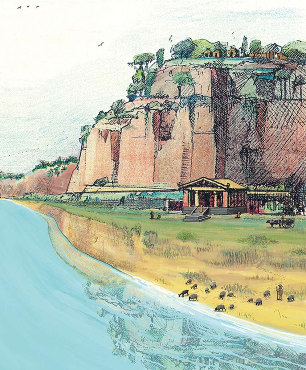
FIG. 5. Visualisation of the early archaic riverbank looking north towards the harbour temple and the Capitoline Hill, depicted with a low river level. (Lorene Sterner, after Ioppolo in Pisani Sartorio Reference Pisani Sartorio1989)
When building in the river valley, the archaic inhabitants of Rome surely acted with intimate familiarity with the Tiber's seasonal behaviour and made informed decisions about necessary flood-mitigation measures. Exposure to flood waters would have catastrophically eroded the temple's mudbrick superstructure, undermining its elaborate terracotta décor and ruining the wooden cult statue housed within. We can be confident that inhabitants would not have invested such economic and cultural resources in a position that was perceived to be susceptible to inundation. Positioned atop this natural ledge at 6.5 masl, a 1.7 m high podium — made from an unusually dense variety of tufo lionato imported from the Anio region that would have been more resistant to water damage than local stoneFootnote 68 — further lifted the temple's vulnerable superstructure to an elevation of 8.2 masl. For comparison, it is important to note the first gravel surface of the nearby Forum Romanum, where an archaic land-reclamation project filled the valley and raised the ground level to 8.6 masl.Footnote 69 These two elevations provide a strong indication of the height perceived to be ‘safe’ in the early sixth century. It is also worth reiterating that our investigations have documented pre-republican flood deposits only as high as 7.4 masl, this being the upper limit of the land surface beneath the Sant'Omobono sanctuary. While determining the magnitude of ancient flood events is difficult for reasons acknowledged above, this combination of topographical and archaeological evidence offers compelling proxies. We suggest that at the time the harbour temple was built, a flood reaching more than 8 masl would have been an exceedingly rare event.Footnote 70 It seems that Rome's first monumental temple, unsurprisingly, was erected in a position that was highly visible as well as offering relative safety from inundations (Fig. 6).
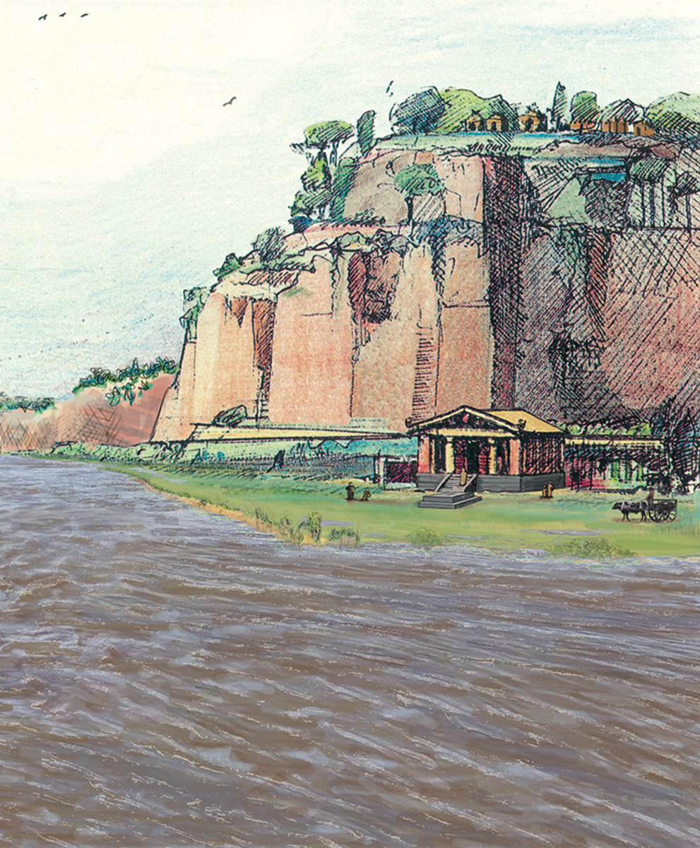
FIG. 6. Visualisation of the early archaic riverbank looking north towards the harbour temple and the Capitoline Hill, depicted with a high river level. (Lorene Sterner, after Ioppolo in Pisani Sartorio Reference Pisani Sartorio1989)
V TRANSFORMATION OF THE RIVER VALLEY
The Shifting Tiber and the Formation of a New Riverbank
Over the course of the sixth century, Rome's fluvial system became unstable, and the river valley began a significant transformation. While the plain along Via Petroselli and the Lungotevere had previously been subjected to intense erosive forces that had kept the surface in or near the active river channel very low (c. 1 mbsl), the area now began to fill with sediments deposited by water. This accumulation was clearly not the result of anthropic dumps or building projects, which would have served to indicate that the modification of Rome's riverbank was the result of reclamation projects or general urban encroachment.Footnote 71 Instead, the stratigraphy consists of layers of silts, like those found in seasonally dry floodplain environments, and is observable in cores across the Forum Boarium.Footnote 72 Simultaneously, and perhaps in response to this sediment newly accumulating along its east bank, the Tiber river began shifting westward towards its modern course. It is difficult to determine whether the sedimentation along the east bank prompted the shift in the river's course or was a consequence of it, as the two processes are inextricably linked. Regardless of the precise reasons for the river's movement, the hydrological and topographic changes in the Forum Boarium valley are apparent.Footnote 73 The erosive power of the river and its two tributary streams was no longer counteracting the depositional forces as it once had. As the area filled with fluvial sediments, the ground level was raised and extended westward over time: a high, wide riverbank emerged in the valley between the Capitoline and Aventine Hills.
The chronology of this sediment accumulation along the Tiber's east bank is secure. Although there are infrequent anthropic inclusions within this thick horizon of silt deposits, abundant ceramic evidence from the abandoned river channel found at elevations around 1 mbsl (above, Section III) provides a clear terminus post quem: the westward shift of the Tiber's course and the intensive sedimentation commenced after the beginning of the sixth century. Furthermore, a massive renovation at the site of Sant'Omobono in the early fifth century b.c.e. confirms that the sedimentation occurred rapidly and had immediate implications for operations in the river valley. Excavations have demonstrated that the temple, built atop the high section of riverbank in the early sixth century, was abandoned by the end of the century. In the decades that followed, a monumental platform, measuring c. 47 m per side and standing roughly 5 m in height, buried and supplanted the archaic cult site with a new sanctuary complex that included twin temples of Fortuna and Mater Matuta.Footnote 74 Core 47 exposed tuff blocks from a low western shoulder or terracing wall associated with this early fifth-century platform, covering a thick pack of fluvial sediments (Fig. 7).Footnote 75 As well as revealing a previously unknown architectural feature, this discovery provides an important terminus ante quem for the accumulation from 1 mbsl up to 5 masl.Footnote 76 Taken together, even the longest and most conservative timeline is staggering: nearly 6 m of sediment was deposited beside the older riverbank over the course of the sixth century.Footnote 77 In addition to core 47, boreholes from the central and eastern Forum Boarium (43, 50, 51, 52 and 54) all exposed comparable sedimentation up to and beyond 5 masl. The evidence, therefore, indicates that a high riverbank gradually subsumed the pre-existing low-lying shore in the southern part of the Forum Boarium after the beginning of the sixth century.
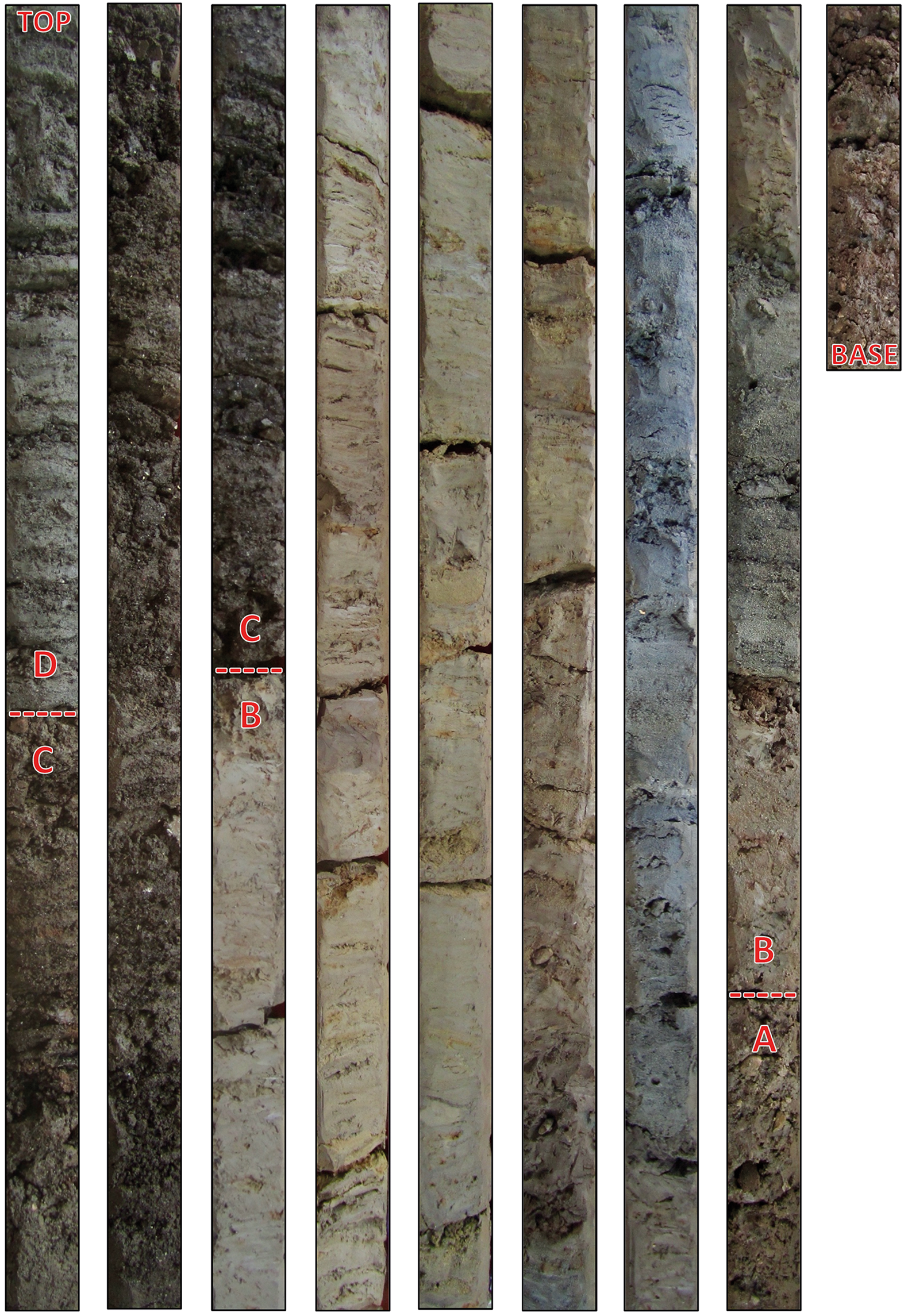
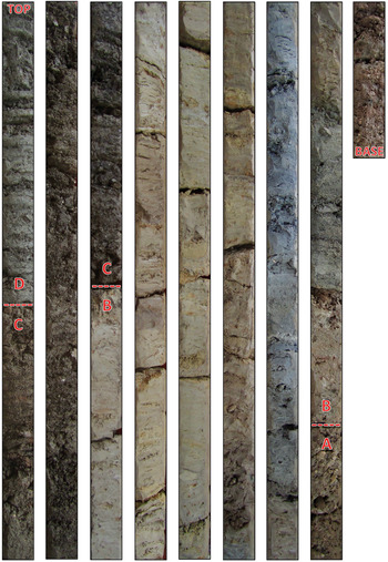
FIG. 7. Photographs of core 47 from 0.8 mbsl at the base to 7.5 masl at the top, showing key stratigraphy including: (A) deposits associated with the early archaic river channel; (B) floodplain deposits associated with the sixth-century sedimentation; as well as (C) cappellaccio and (D) lapis Albanus tuff blocks associated with the early fifth-century platform at the Sant'Omobono sanctuary. (Andrea L. Brock)
While it is clear that this process of fluvial transformation began sometime in the sixth century, it continued well into the republican period. Cores further west (39, 44, 45, 46, 48, 55, 57 and 58) exposed a similar sequence of silts, but with more prolific inclusions of ceramic sherds, several of which are mid-republican.Footnote 78 In other words, the Tiber seems to have moved westward gradually, while overbank flooding and sedimentation progressively widened and elevated the floodplain through the early and mid-Republic. Fluvial sediments accumulated in the area of the Forum Boarium at least until the third century b.c.e.; floodplain silts, which are physically beneath and chronologically before anthropogenic deposits with inclusions of mortar fragments, are found up to 7 masl in cores in the southern Forum Boarium and up to 9 masl further north.Footnote 79 In some areas, the ground level had risen by more than 10 m as a result of siltation since the beginning of the sixth century. Even as the valley filled, the southern part of the Forum Boarium continued to be one of the lowest points in the city, leaving a visible imprint of the original harbour.
The progressive river movement and formation of the new riverbank from the sixth century onwards would have been acutely perceptible to local inhabitants: the conditions that had once facilitated a natural harbour and ford at Rome's shore would have disappeared by the beginning of the republican period. By the third century b.c.e., the Tiber flowed further from the city, and a new riverbank stretched between the Capitoline and Aventine Hills (Fig. 8). In order to comprehend and appreciate the Romans’ responses to these substantial changes, it is necessary to consider first the causes and effects of this transformation.

FIG. 8. Topographic reconstruction of the mid-republican riverbank in the Forum Boarium, noting the position of key structures or features mentioned in the text. (Daniel P. Diffendale)
Inferring Causes: Urbanisation
One of the most dynamic natural forces on the planet, rivers are complex systems that are highly susceptible to changes within their broader environment. Even subtle adjustments to water or sediment inputs or outputs across the regional watershed can impact a river's depositional and erosional behaviour. For these reasons, it is difficult to identify with certainty the causes of this transformation of Rome's river valley, but we can offer reasonable inferences.
At least two natural factors might have contributed to the newly documented sedimentation process. First, as the Tiber shifted westward, the older sections of river channel along Via Petroselli were especially prone to siltation. With the river's course moving further away, this newly established, marginal zone would have been subjected to overbank flooding, but shielded from the river's strongest erosive force. Second, a wetter regional climate could have caused increased erosion, correlating to more water and sediment being washed into the river. Although there is some evidence for higher levels of precipitation in the mid- to late Holocene, there is insufficient data to demonstrate the spike in rainfall in this particular period which would be necessary to account for the siltation documented in the Forum Boarium. Such climatic variability ought to be identifiable in the sedimentary records from other lakes and rivers in the area, but clear parallels for the phenomenon observed at Rome are currently lacking.Footnote 80
In addition to these natural factors, human impact is a significant potential cause of the sedimentation. More than a dozen major building projects at Rome are dated archaeologically between the late seventh and the early fifth century b.c.e.Footnote 81 This urban growth would have necessitated extractive ventures on the landscape in and around Rome: quarrying for stone, as well as deforestation for construction material and fuel.Footnote 82 These activities, especially when operating at scale, would result in increased surface runoff and sediment influx in the river valley. Additionally, we can assume that the installation of drainage channels would have seriously exacerbated the situation. Whereas two tributaries once met the Tiber somewhere in the area north of the Aventine Hill, these streams were eventually canalised.Footnote 83 While this infrastructural investment would have aided drainage and drying further up the valley (as in the area of the Forum Romanum), the streams’ seasonal movement and naturally erosive behaviour would have been restricted wherever they were encased in their channels. Once these streams were no longer free to erode laterally across their respective valleys, sediment deposited during overbank flood events would continuously accumulate and (in the areas outside of the Tiber's active channel) remain uneroded. This (probably unforeseen) repercussion of Rome's drainage infrastructure would have the largest implications for the lowest part of the valley, precisely the area most prone to flooding. For centuries and millennia, a section of the east bank of the Tiber had been kept low by the erosive force of the tributary streams; the conversion of this confluence into the mouth of the Cloaca Maxima would have had a dramatic impact.Footnote 84
It is not yet possible to distinguish and quantify with certainty the degree to which natural and anthropic forces contributed to the transformation of Rome's river valley. The correlation between the chronology and scale of urbanisation at Rome and the siltation in the Forum Boarium valley is, however, quite striking. We suggest that the two phenomena are logically related. Rivers are extremely prone to anthropically driven change. As urbanisation processes at Rome reshaped the natural topography of the site from the sixth century onwards, it would necessarily have had repercussions for the Tiber river — and especially the region around the original river harbour. Whether the early inhabitants of Rome understood the connection between their urban endeavours and the changing topography of their river valley is unfortunately obscured by the lack of a contemporary literary record. However, inhabitants were undoubtedly keenly aware of the intensifying threat of floods that tracked their urban growth.
Inferring Effects: Escalating Floods
While Rome's valleys indisputably flooded in the prehistoric era, this probably did not create tremendous problems. On the one hand, there was simply less infrastructure in the valleys at risk of inundation: early urban investments seem to have been clustered on elevated sections of the landscape, including the high ledge at the base of the Capitoline Hill and the reclaimed land in the Forum Romanum. On the other, the available evidence suggests that floods in the early Archaic Period rarely, if ever, exceeded 8 masl. Furthermore, we should envision floods at Rome as seasonal and somewhat predictable, so that activity in parts of the valley susceptible to inundation could be readily relocated or temporarily disbanded. However, this hydrological reconstruction is only applicable to the relatively unmodified landscape and stable fluvial system that existed until the sixth century.
Coring evidence indicates that flood levels at Rome increased markedly from the sixth century onwards. As the lowland filled with sediment and the ground level of the riverbank district rose and pushed westward, floodwaters had ever less room to spread and would have climbed to progressively higher elevations. This reconstruction, therefore, provides a compelling reason for the radical overhaul of the Sant'Omobono sanctuary at the turn of the sixth–fifth centuries b.c.e.: whereas the archaic harbour temple was once situated in a safe position several metres above the river, in the two or three generations that followed, the area became subjected to novel sedimentation and hydrological forces. The 2013 deep trench excavation at Sant'Omobono revealed a layer of fluvial sediments covering archaic levels and deposited near the temple podium; this may be the remnants of a flood capable of affecting the mudbrick temple. After the abandonment of the archaic temple, the early republican construction effectively re-established the topography as it once was: a (now artificial) terrace projecting from the side of the Capitoline Hill, standing several metres above the river below. Seated atop this platform at an elevation of 13 masl, the twin temples of Fortuna and Mater Matuta were presumably in a position that afforded relative safety from most contemporary floods.
Over the centuries, valley reclamation projects and general urban encroachment would have further constrained floodwaters and amplified their height.Footnote 85 Whereas floods had deposited sufficient sediment to raise the ground level in the Forum Boarium to 9 masl by the mid-Republic, flood sediments are found as high as 11 masl. The historical record, furthermore, documents the recurrent challenge of Tiber floods, which exceeded 15 masl by the first centuries b.c.e./c.e..Footnote 86 Floods on this scale may have been comparatively rare events, but the general trend is nonetheless apparent from the geoarchaeological and literary evidence: even as the ground level rose substantially, Rome's lowlands became ever more susceptible to inundation. As the river valley and the city itself rose, the Tiber responded in kind with floods reaching increasingly higher levels.
The dire situation is evocatively illustrated by voices from the ancient literary record. For example, an exceptional flood that struck Rome in early March of 69 c.e. was remembered as an alarming prodigy of the tumultuous events of that year. A young man of thirteen at the time, Tacitus may personally have witnessed the episode, which he notes ‘flooded not only the low-lying and level areas, but also those usually safe from this sort of catastrophe’. He goes on to recount the consequences for the city's lowlands: ‘Many were swept away from the public squares and many more were cut off in their shops or beds. The foundations of apartment buildings were degraded by the stagnant waters, only to collapse when the river receded’.Footnote 87 The Romans needed either to adapt their lowland activities progressively over the centuries, or to accept the periodic destruction and devastation wrought by the Tiber. Few, if any, other urban communities in central Italy faced environmental challenges of such existential import.
VI THE EMERGENCE OF ROME'S HISTORICAL RIVERBANK
Romans of the mid-Republic had a very different riverbank district than their archaic predecessors. It became, for one thing, a much larger region. Instead of being restricted to the high ledge beneath Sant'Omobono and the low shore at the termination of the Velabrum valley, a long and wide swath of new riverbank evolved between the Capitoline and Aventine Hills. Although the recently formed real estate in Rome's river valley would offer new opportunities, the implications for Rome's original harbour are profound. As the valley filled and the ground level rose, the river hydrology would have also changed. This area, formerly characterised by a wider channel and dissipated waters, would have been constricted, so that the water may have begun to flow deeper and faster. Moreover, the formation of a high riverbank would have been far less accommodating for harbour and fording activities, at least as they had conceivably once operated.
This story of Rome's original river harbour should, therefore, be understood as a prologue to the well-known challenge later faced by Rome of maintaining port operations in the face of silting at Ostia and Portus. The dynamism of the riparian landscape would have serious ramifications for the nascent city and its ability to continue capitalising on the flow of people and goods between Etruria, Latium, Campania and the wider Mediterranean after the sixth century. The natural advantages offered by the site faded as the city grew, leading to new and unforeseen challenges. At a time when Rome was a regional leader, but still centuries away from establishing an imperial road network, the maintenance of transit lines and river operations would have been vital for the city's continued prosperity. This was a challenge that demanded an adaptable community.
Rather than being pulled up onto a low shore, boats arriving at Rome in the republican period would have required mooring structures along the riverbank: a proper port, not just a natural harbour. Although we lack clear-cut evidence for the earliest port infrastructure in the Forum Boarium, the cores do show sporadic indications of anthropic fill deposits and stone constructions that could be associated with embankment walls or other port works. Unlike the high walls that separate the Tiber river from the modern city, embankments at Rome in the ancient period were disjointed and low at points; flood containment, therefore, was likely not the intended objective. Instead, these embankment walls served other important purposes: shielding the riverbank from erosion and serving as quays at which boats could be tied and stabilised broadside to the bank for the purposes of unloading goods.Footnote 88 The low terracing wall arguably associated with the early fifth-century renovation of the Sant'Omobono sanctuary (above, Section V) could, in theory, have facilitated port activity alongside the high riverbank in the northern part of the Forum Boarium. Although difficult to prove from the extant evidence, such a hypothetical reconstruction of early port infrastructure adjacent to the Sant'Omobono sanctuary would account for the placement and orientation of the Temple of Portunus, with its back to the archaic harbour due south, facing north towards what may have been the early republican port. In any case, the position of early embankment walls and quays would probably have required periodic adjustment, as the borehole record makes it clear that overbank flood sediments continued to accumulate in the area of the Forum Boarium into the mid-Republic.
The process of urbanising a river valley changes the ecology: once an area is paved, it is logical to expect that any silts deposited during a flood event would be cleaned up, rather than being left in situ and allowing the surface to aggrade gradually. In other words, once a floodplain is urbanised, land inflation as a result of sediment accumulation is halted, while urban infrastructure in the area remains extremely vulnerable to flood waters. In the case of the stretch of land between the Capitoline and Aventine Hills, fluvial sediment was deposited at least into the third century; only then, it seems, was the area extensively paved or built up. Although this area along the river had certainly been a major hub of activity since the beginning of sedentary habitation at the site, the significant degree of landscape change and land inflation in the river valley suggests that human activities must have been ephemeral or supported with limited built infrastructure (with the exception of the Sant'Omobono sanctuary) until the third century b.c.e.
Both the archaeological and literary records confirm that the Romans made major investments in the Forum Boarium in the mid-Republic, reinforcing the riverbank and limiting further changes to the fluvial topography.Footnote 89 Excavations at the Temple of Portunus and the Round Temple have revealed that both structures rest atop embankment walls, which were constructed sometime between the late fourth and early second centuries b.c.e.Footnote 90 This broadly reflects the western edge of the siltation and the newly established position of the riverbank. The course of the Tiber river as it flowed through Rome became relatively static thereafter. Livy mentions the installation of extensive port infrastructure along the Tiber bank in the first half of the second century b.c.e.: his account is vague, but generally indicative of efforts to build or refurbish pre-existing riverside walls, quays and porticos.Footnote 91 Even after the position of the riverbank and river channel stabilised, Rome's riverside infrastructure would have required regular maintenance over time: at a minimum, reinforcement of the Tiber bank and dredging to clear a path for boats to manoeuvre.Footnote 92 It is perhaps not surprising, therefore, that from at least the Late Republic a series of bureaucratic offices (curatores riparum and the like) were established to handle issues of river management.Footnote 93
The river's movement and sedimentation from the sixth through the third centuries created the land that would be known as the Forum Boarium: a high riverbank monumentalised with temples and crowded with port infrastructure and market activities. The developed riverbank familiar to ancient and modern authors shared little resemblance with the unencumbered shore that existed before the growth of the city. Although this process of urbanising the riverbank helped to stabilise the landscape in the Forum Boarium, it also meant that structures were built in areas at risk of flooding on an annual basis, creating new and enduring challenges for the inhabitants of the Eternal City.Footnote 94
VII CONCLUSION
Rome's disjointed hills and flood-prone valleys were not perfectly conducive for the growth of a city, but the site was nonetheless strategic. Our geoarchaeological research provides the first empirical evidence not only for a natural river-crossing and landing for boats, but also for an elevated section of riverbank that provided a safe place for the growth of river-related infrastructure. These unique conditions both incentivised and facilitated urbanisation. As the settlement took an increasingly urban form in the sixth century, this opportune river valley — which had arguably helped the Romans become players on the Italian and Mediterranean stage — was radically transformed. Sometime around the beginning of the Republic, Rome's original river harbour ceased to exist as the area silted up. In the face of dynamic ecological conditions and escalating floods, the maintenance of commercial enterprises would have required a sophisticated socio-political system: a centralised authority, organised and communal effort, surplus resources and labour and strategic urban planning. Generations of Romans responded proactively by adjusting their riverbank activities and harbour infrastructure. The inhabitants’ adaptive measures, which occurred promptly in response to the instability of the Tiber in the sixth century and continued for centuries thereafter, serve as a testament to the ingenuity and resilience of the community. While the Romans are renowned for their ability to exploit, modify and overcome challenging landscapes across their Empire, the reality is that they had been doing so ‘at home’ from the very origins of their city.
Ultimately, it is becoming clear that building the Eternal City was not a linear, predetermined, or easy process. The form and trajectory of Rome's prehistory was shaped (not exclusively, but to a meaningful degree) by the opportunities and challenges offered by the natural landscape — and the contours of the ecological situation changed profoundly alongside societal growth at the site. By elucidating these complex human–environment negotiations, we stand to gain new perspectives on the social and political developments in early Rome, the very processes that created the vibrant republican society that eventually emerged from the murky waters of prehistory. By illuminating the stage that was the landscape of early Rome, it becomes possible to see the actors more clearly, and to understand how the drama changed with each act.


 Open access