


Introduction
Libya is the fourth largest country in Africa, with a long coastline spanning over 1770 km from the Tunisian to the Egyptian border. Evidence from prehistoric caves, flint scatters and rock art show that people lived along this coast for millennia, primarily engaging in hunter/gatherer activities. The sea provided a rich source of food, so much so that marine and terrestrial molluscs decreased noticeably in size, which suggests overexploitation of this resource. From around the eighth century BC, people started to engage in animal husbandry (Barker et al. Reference Barker, Hunt, Reynolds, Brooks and el-Rishi2007, Douka et al. Reference Douka, Jacobs, Lane, Grün, Farr, Hunt, Inglis, Reynolds, Albert, Aubert, Cullen, Hill, Kinsley, Roberts, Tomlinson, Wulf and Barker2014, Barker Reference Barker2019). In the late seventh century BC, Greek settlers arrived in Cyrenaica and established a number of settlements, including the well-known Classical-period port cities of Euesperides, Taucheira (Tocra), Ptolemais and Apollonia. The arrival of the newcomers changed the landscape of the Gebel Akhdar significantly with the establishment of agriculture and planting, for instance, wheat, barley and olive trees. The harbours connected the inhabitants of Libya to the wider Mediterranean world through maritime trade and socio-political connections, fostering exports and imports across the eastern and western Mediterranean. In the late first century BC, Cyrenaica was incorporated into the Roman Empire and the cities, settlements and farms continued to flourish. It became part of the Byzantine Empire in the late fourth century AD, and finally came under Arab control in 642 AD. During the Late Roman, Byzantine and Arab periods, the large cities of Cyrenaica slowly began to decline in importance and influence, but many were still lived in for centuries. This very brief whistle-stop tour of the history of Cyrenaica does not do justice to the dynamic events that took place over the centuries, but it does highlight the multifaceted and unique coastal and maritime heritage that remains until today.
Maritime heritage connects two very distinct areas: the sea and the land. It encompasses coastal and underwater features, traditional material cultures and archaeological sites located at the coast. Furthermore, it includes tangible and intangible heritage, but in Libya, traditionally, more focus has been placed on the tangible aspects (see Bennett Reference Bennett2017 on intangible heritage projects in Libya).
Despite the region's long-standing and strong connection to the sea, maritime archaeology remains a peripheral, but growing, branch of archaeology in Libya. In 2005 Libya ratified the UNESCO Convention on the Protection for Underwater Cultural Heritage (UNESCO 2001). Unfortunately, civil unrest following the Arab Spring in 2011 hampered efforts in building capacity and delayed the establishment of a dedicated maritime archaeology unit until 2012; nevertheless, capacity and funds remain low. The limited underwater investigations and documentation so far have predominantly been carried out by foreign missions with support from DoA members, including at Apollonia, Tocra and Ptolemais, but so far very few underwater investigations have been led by Libyan teams (see relevant sections below).
In many cases, the marine and coastal environment in which this cultural heritage is located is a fragile one. Events related to climate change, such as increased wave action due to storm surges, changes in rainfall and rising relative sea levels can cause erosion and, in some cases, submersion (Vousdoukas et al. Reference Vousdoukas, Mentaschi, Voukouvalas, Verlaan, Jevrejeva, Jackson and Feyen2018, Reference Vousdoukas, Ranasinghe, Mentaschi, Plomaritis, Athanasiou, Luijendijk and Feyen2020, Reference Vousdoukas, Clarke, Ranasinghe, Reimann, Khalaf, Duong, Ouweneel, Sabour, Iles, Trisos, Feyen, Mentaschi and Simpson2022; Westley et al. Reference Westley, Andreou, El Safadi, Huigens, Nikolaus, Ortiz-Vazquez, Ray, Smith, Tews, Blue and Breen2021, Reference Westley, Nikolaus, Emrage, Flemming and Cooper2023). While the current impact of climate change is a phenomenon that has developed more recently, changes in relative sea level have impacted archaeology in Libya for much longer. Many of the ancient harbours that dotted the Libyan coast in antiquity are now submerged. This was caused by a series of earthquakes that hit the Mediterranean in Late Antiquity and the early Islamic period, causing tectonic movements that led to subsidence of up to 3 metres or perhaps even 4 metres (Yorke et al. Reference Yorke, Davidson and Little1972, Baika Reference Baika, Blackman and Rankov2013, Flemming Reference Flemming2021).This essentially invisible marine cultural heritage is, furthermore, under increasing threat of looting as the uptake of recreational diving is increasing.
In addition to the challenges caused by natural processes, rising population numbers (1,426,986 people in 1960, 6,735,277 people in 2021) (World Bank 2023) and a population shift from the interior to the coast has meant that the littoral settlements have exploded in size. Even previously small coastal villages are now sizeable settlements and the trend of urban expansion continues along the coastline (Alawamy et al. Reference Alawamy, Balasundram, Hanif and Sung2020). This rise in population, coupled with the location of the major cities along the coast, means that maritime heritage in Libya is under immense pressure.
This contribution aims to give an overview of the maritime projects that have been carried out in Cyrenaica in the past and will provide some thoughts on how the discipline could develop in the future. Furthermore, it will highlight some of the amazing coastal and maritime cultural heritage sites Cyrenaica has to offer. The Cyrenaica Coastal Survey will serve as a case study of an ongoing project that has documented and assessed the condition of sites between Apollonia and Tocra, which will reflect some of the major threats and damage that coastal and maritime cultural heritage faces along the coast of Libya today.
Previous work by foreign missions
Libya contains hundreds of coastal archaeological and historical sites and monuments from different cultural periods, whether they are located directly on the coast or submerged under the sea. To date, this great legacy has not received due attention, either from European travellers who visited the region from the nineteenth century onwards, or from those who followed them from foreign and local archaeological missions. Here we provide a brief overview of the history of archaeological research and documentation of these sites from the nineteenth century until the present day.
Amongst the nineteenth-century travellers who visited the region, Beechey and Beechey (Reference Beechey, Beechey and Murray1828) left the most comprehensive account. The brothers visited many of the major harbours (e.g. Leptis Magna, Apollonia, Tocra, Ptolemais, Berenice), and provided us with detailed descriptions and maps of the archaeological remains they encountered. The Beechey brothers left a description of some small sites that lie directly on the seashore, from Sirte in the west to Derna in the east. They also describe some of the architectural monuments in Apollonia and Ptolemais on the seashore and extending below the water. In 1828, the French traveller Pacho (Reference Pacho1827) visited Apollonia and some other coastal sites in Cyrenaica, such as Ras el-Hilal, and Lathrun, and left a description and some drawings. Other travellers also noted some coastal sites in Libya (e.g. Barth Reference Barth1849, Hamilton Reference Hamilton1856, Smith and Procher Reference Smith and Procher1864, Haimann Reference Haimann1882).
The earliest attempts to investigate the submerged archaeological remains in Cyrenaica are those attributed to D. Forrow in Apollonia in 1957 (Goodchild et al. Reference Goodchild, Pedley, White and Humphrey1976). In the following year a mission from the University of Cambridge, headed by Nicholas Flemming, documented and interpreted many of the submerged archaeological features of the ancient harbour of Apollonia. This important and pioneering work produced an accurate plan of these features, which identified the location of the harbour, its extension and its various architectural elements represented in the quays, the lighthouse, the breakwaters and more. These works, which were carried out by divers during 1958 and 1959, showed that the harbour of Apollonia is one of the most important ancient ports in the world. This fully submerged harbour (due to shifts in tectonic plates) is unique as it is one of the few that is complete, retaining some of its very early features from the seventh and sixth centuries BC, and its stratigraphy is preserved from the Hellenistic through to the late Roman period (Flemming Reference Flemming1959, Reference Flemming1960, Reference Flemming and Du Plat Taylor1964, Reference Flemming1971, Reference Flemming2021).
At the end of the 1960s a British team, including Robert Yorke, David Davidson and John Little, examined features at several ancient harbours in Cyrenaica for three weeks, with an emphasis on survey work in the harbours of Ptolemais and Tocra. In addition, the survey included some minor harbours such as Al Hamamah (Phycus), Zawiet el-Hanya (Aptouchos) and Driana (Hadrianopolis). A quick visit to the harbour of Apollonia has since been made to examine its elements to make some comparisons. At Ptolemais, the survey put an end to the controversy and disagreement among researchers about the location of the harbour. The discoveries of some of the harbour's facilities proved that it is located to the east of the promontory not to the west, as stated in some previous studies. At Tocra, underwater surveys were carefully conducted along the waterfront of the city, which revealed some remains and archaeological evidence indicating that the city had an artificial harbour whose architectural elements were in line with the Hellenistic city plan. The British team's work at the site of Zawiet el-Hanya (Aptouchos) can be considered as the first archaeological survey work to be conducted at the site, which revealed some of its architectural elements (Jones and Little Reference Jones and Little1971, Yorke Reference Yorke1972, Yorke and Davidson Reference Yorke and Davidson2017). Stucchi (Reference Stucchi1975) also recorded a number of remains at coastal sites, including at Rasl el-Hilal, Zawiat el Hanya, Al-Ogla and Gergerummah.
Since the beginning of the 1980s, the submerged features of the harbour in Apollonia have received attention from the French archaeological mission working in the city (Laronde Reference Laronde1981, Reference Laronde1983, Reference Laronde1985, Reference Laronde1987, Reference Laronde1989, Reference Laronde and Lincea1990; Laronde and Sintés Reference Laronde and Sintés1998). During these surveys, many of the harbour's architectural elements were documented and it was stated by Laronde that the inner basin of the harbour was intended to serve as a military harbour. Through these studies, the French mission has proved that the harbour of Apollonia is one of the most important and oldest Greek harbours in North Africa. Furthermore, two shipwrecks from the second century BC have been identified in the outer basin of the harbour (Long Reference Long1992). In addition to the work in Apollonia, the French mission carried out some surveys and quick visits to some coastal sites in the region. These included the site of Naustathmos (modern Ras el-Hilal), Phycus (Zawiet el-Hamama), Kainoplois (Al-Ogla) and Zawiet el-Hanya. The latter site was considered by Laronde to be the ancient coastal site known as Aptouchos, not Ausigda as other researchers have suggested. It is also worth noting the underwater works that were carried out in Marsa-el-Brega, (ancient Borium) in Sirtica in 2000 to collect, document and study a shipment of submerged pottery (Preece Reference Preece2000).
To assess and document the extent of erosion along the waterfront of the ancient city of Tocra, a rapid survey was conducted in 2002 by a mission from the Society of the Libyan Studies working in Euesperides (Greek Benghazi). The wind- and wave-scoured escarpment was recorded using digital photography and a measured survey of the existing coastline was also rapidly undertaken. By comparing the results of this survey with the site plan constructed in 1966, it was confirmed that what was washed away by winter storms and high sea waves amounted to about 20 metres over 40 years. In addition, several discoveries that emerged because of erosion by sea waves were photographed and documented (Bennett et al. Reference Bennett, Wilson, Buzaian and Kattenberg2004).
In 2007, the Libyan government started a project to evaluate and preserve Libyan cultural heritage called ‘The Project for the Preservation and Restoration of the Cultural Heritage in Libya’. The objective of this project was to manage the archaeological sites that are submerged and prepare them as tourist destinations. In this context, the Libyan government contracted the Italian Association (Archeotema) to evaluate the port of Apollonia and develop a vision for its management and tourism. The association carried out some works, including underwater surveys of landmarks that were documented and mapped in the past, and concluded that it was possible to create a tourist path for divers to visit certain points and to manufacture or import glass-bottomed boats that enable visitors to see the archaeological features (Pizzinato and Beltrame Reference Pizzinato and Beltrame2012). As part of the same project, underwater surveys were carried out in 2009 in both Ptolemais and Leptis Magna. These surveys conducted additional studies on previously discovered archaeological features. In addition to those studies, other archaeological remains were discovered in the two harbours. At Ptolemais, the survey covered the area extending from the western shore of the city to the large island on the eastern side. Among the discoveries resulting from this work are the remains of an ancient boat, represented by the hull with mortise-and-tenon joints.
The Western Marmarica Coastal Survey Project (2007–2010), conducted by the University of Cambridge, covered an area extending for about 80 km from Kampot in the east to Ras Melha in the west (about 80 km from the Libyan–Egyptian border). One of the objectives of this project was to search for evidence of maritime communication within the region and the maritime trade systems during the late Bronze Age, and therefore any evidence of the Libyan civilisation during that period. During this survey about 120 sites were documented on the coast of Marmarica, extending from the Middle Stone Age to the post-Roman period (although most date to the late Roman period). Some of the sites located by the sea have been documented, ranging from large settlements, such as Wadi Douma and Marsa Lak, to small farms and agricultural villages (Hulin Reference Hulin2008, Reference Hulin2012; Hulin et al. Reference Hulin, Timby and Mutri2009, Hulin et al. Reference Hulin, Muftah and Mutri2010).
In 2006, a team from the University of Mainz in Germany conducted a survey along the coastal strip between Tocra and Ptolemais, focusing on the early Hellenistic to Islamic periods. They recorded over 525 findspots, many of which were related to the ancient cemeteries west of Ptolemais (Weber-Karyotakis and Berger Reference Weber-Karyotakis and Berger2016). The Frenchman Jean-Pierre Misson conducted specific underwater survey works at Zawiet el-Hanya in 2009, which is considered to be the first work of its kind at the site. Among the results of this work 12 stone anchors were found (de Graauw and Misson Reference de Graauw and Misson2013).
Between 2008 and 2013, with the support of the Italian Ministry of Foreign Affairs, the Italian archaeological mission, headed by Sebastiano Tusa from the University of Naples, carried out its project known as ‘Libyan Underwater Archaeology – Ancient ports of Cyrenaica’. During this project, several coastal sites in eastern Cyrenaica and the coast of Marmarica were surveyed and documented. Terrestrial and marine surveys of the coastal strip were carried out to study the coastal transformation that took place over the centuries and its relationship to human settlement. During this project, diving was undertaken, including at the sites of Phycus and Al-Ogla (Kainopolis). Moreover, some shipwrecks were documented in Al-Ogla, Ras el-Hilal, Ras Al-Tin, and elsewhere (Tusa Reference Tusa2010, Tusa and Buccellato Reference Tusa, Buccellato, Di Lernia and Gallinaro2019).
Overview of work by Libyan teams
The study by Mohamed Hesein on the ancient harbours of Cyrenaica remains one of the most detailed research projects that has ever been conducted. Many coastal archaeological sites were recorded for the first time during this project. Hesein focused on secondary and small harbours located between Al-Ogla and Apollonia. During the survey work, he discovered several industrial features, including 12 pottery kilns. The industrial, economic and commercial role played by small and secondary harbours in Cyrenaica in ancient times has been highlighted in this research. In addition, Hesein described and analysed many architectural features, the construction techniques used, and their typology, chronology and relationship to the main harbours and cities in the region and the surrounding landscape (Hesein Reference Hesein, Leitch and Botte2014, Reference Hesein2015).
In 2012, the DoA established a new Maritime Archaeology Centre based at Shahat (Cyrene), headed by Mr Khaled Dakheel. Since then, the Centre has conducted a small number of underwater investigations at some selected sites in Cyrenaica (Dakheel Reference Dakheelin prep.) At the end of November and the beginning of December 2012, the Maritime Archaeology Centre joined the team of the University of Urbino (headed by S. Tusa) to conduct a survey in the Gulf of Bomba and Ras Etteen, east of Tobruk (Tusa and Buccellato Reference Tusa, Buccellato, Di Lernia and Gallinaro2019). The work carried out by the Libyan team included diving explorations in the vicinity of four islands in the Gulf of Bomba. Among these is El Maracheb Island, which is believed to be the island of Plateia, probably the first location at which Greek settlers arrived in Cyrenaica in the middle of the seventh century BC. The survey documented some of the architectural structures on the island and recovered some submerged pottery sherds (Figure 1). The rounded structures were built with irregular shaped limestones and were located at the centre of the island; they probably date back to the Roman period, as indicated by Roman amphorae sherds found on the site. Dakheel and his team returned to Ras Etteen in October 2020 for another underwater exploration, where they collected some further pottery sherds. These data still await full evaluation.

Figure 1. Diving survey around the island of El Maracheb during which pottery fragments were recorded (images: K. Dakheel).
In November 2019, the Maritime Archaeology Centre held a five-day training course for its diving team, targeting thirteen trainees from Tobruk, Susa, Shahat, Al-Bayda and Tolmitha. It was organised by the Maritime Archaeology Centre and all the training was provided by Mr Dakheel and his Libyan team. After two days of theoretical training, the team conducted practical exercises for three days at Sousa (Apollonia), Ras el-Hilal and Tolmitha. The programme included practical training in survey techniques, documentation, the collection of archaeological finds and the use of technical equipment borrowed from the French archaeological mission working in the region. During this dive-training, some artefacts were collected and handed over to the Sousa Antiquities Office.
The Maritime Archaeology Centre also conducted surveys and underwater excavations in the city of Ptolemais for eight days in November 2020. The team surveyed an area, one kilometre long by half a kilometre wide; some artefacts were recovered and handed over to the Office of Antiquities of Ptolemais. In addition to the male torso of a marble statue and some marble slabs, the team recovered pottery sherds, mainly Roman amphorae (Figure 2). All finds were stored at Ptolemais and are awaiting study by specialists.

Figure 2. Objects recovered from the harbour of Ptolemais. A: torso of a male statue; B: amphora fragment; C: amphora fragments and submerged building blocks (images: K. Dakheel).
Saad Buyadem conducted underwater explorations at Apollonia during his time as an undergraduate student at the Faculty of Archaeology and Tourism in Susa, to collect and document data on submerged archaeology. He discovered new remains that included structures, statue fragments, pottery, coins and inscriptions. (Figure 3). Recently, Buyadem completed his Master's thesis at the University of Asaied Mohamed Bin Ali Al Sanussi, in which he described, interpreted and analysed the archaeological evidence that he had uncovered and documented (Buyadem Reference Buyadem2022). Even though his research has shed light on the submerged archaeology at Apollonia and expanded our understanding of the site, further explorations are needed. The work of specialists would contribute significantly to our knowledge about the history of the harbour and its role in ancient Mediterranean trade. This is not only true for Apollonia, but also for data collected by the Maritime Archaeology Centre. Collaborations with other institutions would help to interpret the invaluable data that has been collected by the Libyan teams.
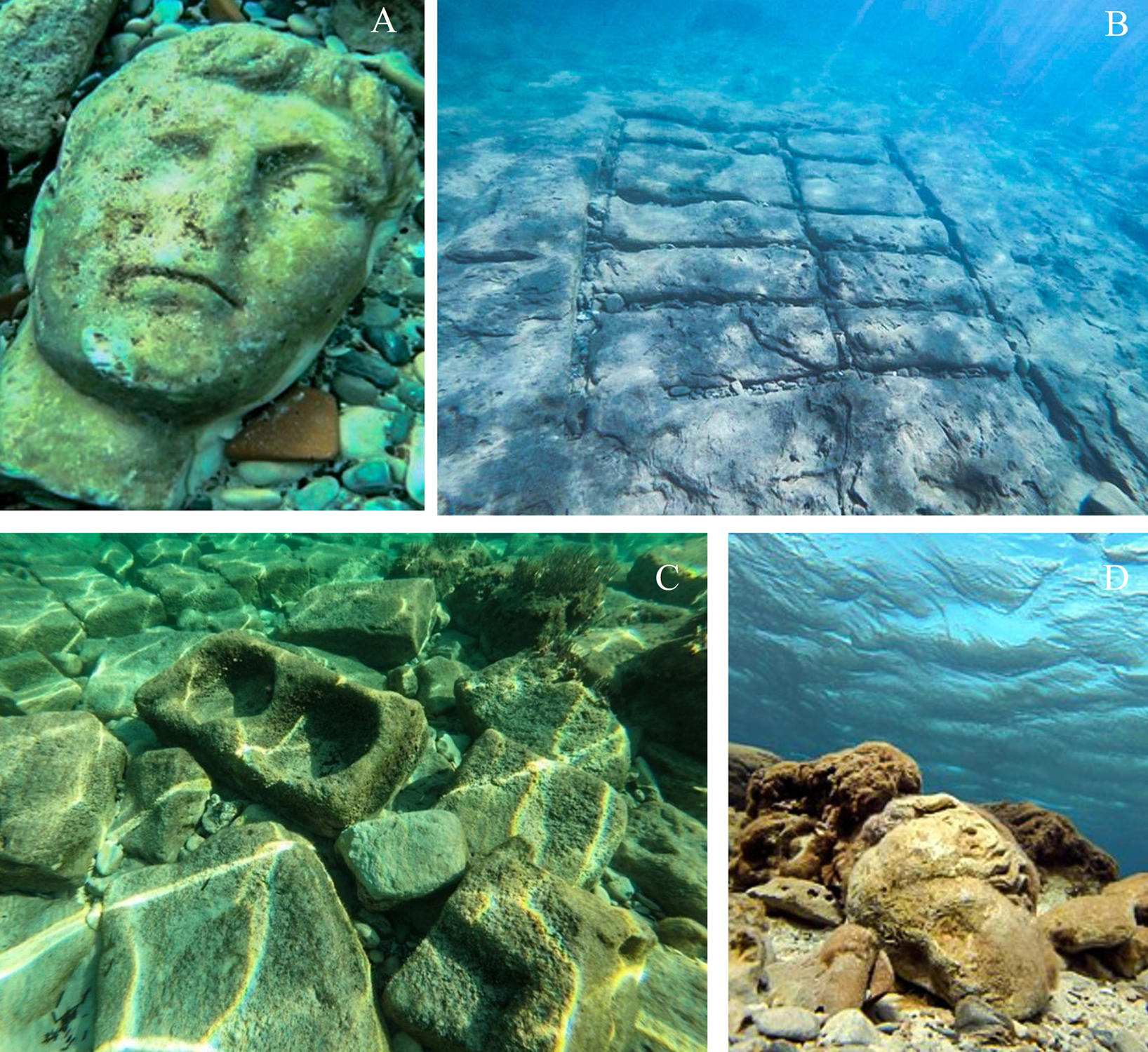
Figure 3. Submerged objects and features at Apollonia. A: statue head of Tiberius; B: stone quarry; C: building blocks; D: head of female statue (Venus?) (images: S. Buyadeem).
Example of a current survey project: the Cyrenaica Coastal Survey (CCS)
The Cyrenaica Coastal Survey (CCS) is an example of a recent collaborative project between the Department of Antiquities in Libya and the Maritime Endangered Archaeology (MarEA) project based at Ulster University and the University of Southampton. The project was born out of the steady increase in threats and damages to maritime and coastal heritage in Libya, and the need for condition and threat assessments, specifically for smaller, relatively unprotected, sites. The main aim of the survey was to record the condition of the sites and to assess their vulnerability in an ever-changing coastal environment. From 2020 to 2022 Libyan heritage professionals from the DoA, the University of Benghazi and the University of Al Bayda systematically recorded threats and damages to sites between Tocra and Apollonia, a coastal stretch of approximately 120 km (Figure 4).

Figure 4. CCS survey area. Stage one from Phycus (Al-Hamamah) to Al-Ogla (Kainopolis) in blue; stages two and three from Tocra to Al-Ogla and Al-Hamamah to Sousa (Apollonia) in yellow (image: J. Nikolaus; Base map via Google Earth Pro, © 2021 Landsat/Copernicus).
The landscape between Apollonia and Tocra consists of a coastal plain bordered by the Gebel Akhdar, the latter being composed of Eocene limestone and reaching up to a height of approximately 880 m in elevation (Hey Reference Hey1956, El-Hawat and Pawellek Reference El-Hawat and Pawellek2005, Hegazy et al. Reference Hegazy, Boulos, Kabiel and Sharashy2011). Around Tocra the coastal plane is about 5 km wide and gradually narrows toward the north-east until the slopes of the Gebel Akhdar reach the sea east of Ptolemais. The plain opens up again at Al-Ogla, broadening to about 1.5 km wide until Phycus (Al-Hamamah), where it gradually narrows down to a maximum of 1 km until it reaches Apollonia.
A desk-based assessment was carried out by MarEA in 2019, which included the interpretation of satellite imagery (Google Earth, Kh7/9 imagery) to identify sites and to conduct an initial condition assessment. The image interpretation and recording was based on the EAMENA/MarEA methodology, aimed at obtaining a greater understanding of the main types of damage and threat affecting sites in the region (Rayne et al. Reference Rayne, Bradbury, Mattingly, Philip, Bewley and Wilson2017a,Reference Rayne, Sheldrick and Nikolausb, Reference Rayne, Gatto, Abdulaati, Al-Haddad, Sterry, Sheldrick and Mattingly2020; Andreou et al. Reference Andreou, Blue, Breen, El Safadi, Huigens, Nikolaus, Ortiz-Vazquez and Westley2020, Reference Andreou, Nikolaus, Westley, el Safadi, Blue, Smith and Breen2022). The on-the-ground survey was divided into three stages: stage one from Al-Ogla to Phycus in 2020; stage two from Apollonia to Phycus in 2021; and stage three from Tocra to Al-Ogla in 2021/2022. Sites were recorded with handheld GPS devices and photographs. Dedicated survey forms that mirror the terminology of the EAMENA/MarEA database were translated into Arabic and used by the survey team. The forms focused on the documentation and assessment of threats and damages, current condition and current/foreseen threats to sites. The data recorded during the survey was entered into the MarEA/EAMENA database and is also available to members of the DoA. In this article, we will focus on the results of stages two and three of the survey (See Nikolaus et al. Reference Nikolaus, Abdrbba and Emrage2022 for the results of stage one). As mentioned above, the focus was on smaller sites as they are, oftentimes, not well explored and only scarcely (if at all) documented. In most cases, they lack well-defined visible boundaries such as fences or walls to protect them, resulting in the encroachment on the site by urban development and/or agricultural activities. Owing to the sheer number of sites not only along the coast but also across country, it is an impossible task for the DoA in Libya to document and monitor them all. Because of this, sites simply disappear under newly built houses or are cleared with bulldozers and ploughs and the DoA has little legal power to prevent this. While the protection of cultural heritage is written into law, the real situation on the ground is different. Law-enforcement has limited knowledge of archaeological sites and antiquities, and training on this subject only exists sporadically (see e.g. Abdulkariem and Bennett Reference Abdulkariem and Bennett2014, Kane et al. Reference Kane, Raynolds and Carrier2017).
From Phycus to Apollonia
The survey between Phycus and Apollonia was carried out in 2021. Today, this approximately 30-km stretch is not very densely settled. A few farms are scattered along the bottom of the steep escarpments of the Gebel Akhdar and the landscape predominantly consists of a mixture of agricultural fields, grazing areas for livestock and sections of natural vegetation. The coastal plane is quite narrow here, up to 1 km in width, expanding to approximately 2 km just west of Phycus. The rocky coastline is intersected by wadis that empty into narrow bays. The beaches in this area vary from gravelly and rocky to narrow sandy beaches, formed by sand precipitation in wadi mouths or strong wave action on limestone formations (IUCN 2011). The relative remoteness of this coastal stretch is explained by a deep wadi approximately halfway between Phycus and Apollonia that cuts the coastal plain in two, preventing a continual coastal road between the two towns. However, the modern settlements of Susah (Apollonia) and Zawiet el-Hamama (Phycus) are rapidly expanding east and west along the coastline. Future building projects are suggested by newly laid-out road grids that branch off towards the sea from the main coastal highway. In addition, urban expansion is increasingly creeping down from Shahat, which has almost reached the coast west of Apollonia.
Type of sites – overview
Thirty-one sites have been recorded along this narrow stretch of coastline (Table 1). Most of them can be attributed to the Roman period based on pottery noted on the ground, but some could be much older. Unfortunately, it was difficult to determine the date and function of some sites without more intensive survey or excavation. However, a high density of industrial activity can be associated with many of them. Such features include kilns, tanks with waterproof lining (cement or plaster), press elements and substantial cisterns (e.g. APO-009, APO-010, PHY-005, PHY-007, PHY-009). One of the largest of such sites was Noat (APO-007; Figure 5D), an oil or wine production site that once held 23 dolia, 15 rock-cut vats, press elements, as well as a pressing floor. It is likely that there was also an anchorage or small harbour here (Hesein Reference Hesein2015, Tusa and Buccellato Reference Tusa, Buccellato, Di Lernia and Gallinaro2019). Underwater explorations by the CCS team revealed that the site did not extend into the sea apart from a square tank (5 x 5 m), which was cut by a wall running east to west. The small, sheltered bay at APO-006, approximately 4 km east of Noat, was probably also an anchorage during the Roman period. A ruinous building, a square cistern and other industrial features are scattered along this bay.
Table 1. List of sites surveyed during the CCS project, showing the type of sites recorded as well as the main disturbances and threats they face.


Figure 5. Example of sites between Apollonia and Phycus. A: Islamic graves made of stones from APO-007; B: small settlement of APO-008; C: rock-cut tomb with small niche and decorated door frame at PHY-001; D: production site of Noat (APO-007) (images: CCS survey).
A small island 3 km west of Sousa's modern harbour also bears witness to intense industrial activity during the Roman period. Large rock-cut and cement-lined tanks could have been used as storage facilities for industrial and agricultural product destined for export to the wider Mediterranean world. The tanks were half-filled with pottery sherds and building blocks when investigated in 1959 (Flemming Reference Flemming and Du Plat Taylor1964). In the past, this island was the headland of a promontory that was connected to the mainland before the tectonic subsidence in Late Antiquity. Locations like this could have served as entrepots for export via the sea (Nic Flemming pers. com.). However, more investigations are needed to fully understand the function of this site. A similar island that was completely modified in antiquity was at Al-Ogla. Excavations in the rock created large rectangular basins lined with opus signum. Tusa and Buccellato suggest that this island was used for fish farming and fish processing. Silos lined in opus signum were probably used for foodstuff and liquid storage (Tusa and Buccellato Reference Tusa, Buccellato, Di Lernia and Gallinaro2019). These islands were not visited by the survey team, but it is important to mention them here, as they played a major role in the local, and perhaps wider, maritime economy.
Four settlements were recorded between Apollonia and Phycus. They consisted of a series of small to medium-sized buildings constructed of a mixture of cut and uncut stones (APO-006, APO-008, PHY-001, PHY-011). APO-008 was probably a small hilltop settlement close to the seashore, consisting of several small domestic buildings (Figure 5B). The small hilltop settlement of PHY-011 (Figure 7D) is located by the sea. Remains of walls criss-crossing the site and a press installation suggest some form of industrial or agricultural activity. The settlement of Sail Amer (PHY-001) is much more substantial, spreading downhill towards the sea over an area of approximately 6 hectares. Here, quarries, rock-cut tombs (some with decorated entrances and niches) (Figure 5C) and sizeable cisterns are visible. Tusa and Buccellato also recorded some possible fish tanks in the vicinity, suggesting that fish farming was practised here. Close to Sail Amer was a large rectangular building (probably a watchtower) constructed of well-cut stones that was located close to the sea (Tusa and Buccellato Reference Tusa, Buccellato, Di Lernia and Gallinaro2019; see also Hesein Reference Hesein2015; Laronde Reference Laronde1983; Stucchi Reference Stucchi1975). Quarries are often located close to settlements or larger structures, many of which were used as locations for rock-cut tombs (e.g. APO-011, APO-012, PHY-002, PHY-004, PHY-014, PHY-018).
Three farms could be identified (APO-001, APO-003 and PHY-017), which had quern stones and/or press elements associated with them. A large dovecote (APO-003) that had the capacity to house around 1200 doves, stood approx. 6 km east of Apollonia. A rectangular building, vats and press elements, probably a farm, are located just to the west of it, but it is unclear if the two are related. Chamoux (Reference Chamoux1992) suggests that due to the sheer size of the dovecote (approximately 8 m in height), it was, more likely, related to a sanctuary than a farm.
The area also shows evidence for some activity during the Islamic period in the form of four small cemeteries. They have largely been constructed with stones from Classical-period sites nearby (APO-003, APO-007, APO-011, PHY-001; Figure 5A).
Site condition
Of the 31 sites recorded between Apollonia and Phycus, 2 are in good condition (no evidence of active deterioration), 15 in fair condition (little evidence of active deterioration), 8 in poor condition (moderate signs of active deterioration) and 8 in very bad condition (serious signs of active deterioration).
Most damage is caused by natural phenomena, namely erosion and deterioration by wind and water action, and vegetation cover (22 sites) and coastal erosion (2 sites, Figure 6). Erosion and deterioration by wind/water is particularly prevalent at sites closer to Phycus, where the topsoil is very thin, and sites and features are built very close to the underlying bedrock. Here, some sites are almost completely eroded away, and only very faint traces of walls are still visible (e.g. PHY-007, PHY-009, PO-002; Figure 9A). Coastal erosion, on the other hand, is more prevalent towards Apollonia, where some of the coastline consists of soft sand, pebbles, smaller rocks and soil (APO-006, APO-007; Figure 9B).

Figure 6. Map showing the primary type of damage to sites between Apollonia and Phycus; (image: J. Nikolaus; Base map via Esri ArcGIS Pro, Earthstar Geographics, scale 1:182,125).
Damage caused by agricultural activities such as pastoral movement and clearing/ploughing of fields (one site, APO-005) or building and development (five sites) occurred mainly close to the modern town of Sousa (APO-001, APO-002, APO-004, APO-012, APO-013; Figure 9C and D). APO-002 is located next to a factory that was constructed between 2003 and 2009. The survey team recorded a rectangular structure, architectural elements, other building stones and a quern, probably dating to the Roman period. The factory perimeter wall seems deliberately to respect the ancient building, although any other surrounding features associated with this site would have been destroyed (Figure 7A).

Figure 7. Examples of damage to sites between Apollonia and Phycus. A: factory built around the site of APO-002; B: lighthouse from the Italian colonial period on top of PHY-012, Mnaret al-Hamamah; C: modern building on top of APO-004, a site with remains of buildings and a quarry on a knoll with dense pottery scatters; D: small settlement near the sea (PHY-011) covered by vegetation and showing the impact of wind and rain over the centuries (images CCS).
Some sites have abandoned modern structures on top of them that were constructed before 2010 (first available Google Earth satellite imagery, e.g. APO-004, APO-012; Figure 7C). A lighthouse was constructed on top of a site called Mnaret al-Hamamah (PHY-012; Figure 7B) during the Italian occupation of Libya. Little remains of the Classical site today, but we can see that it once housed a rectangular building. A large amount of pottery fragments dating from the Hellenistic to the Late Roman period have been noted (see also Tusa and Buccellato Reference Tusa, Buccellato, Di Lernia and Gallinaro2019).
Threat to sites
At the time of writing, the main threat in this region stems from natural factors (27 sites) and three of these are under particular threat (Figure 8). APO-006 has already been mentioned above. This possible anchorage and industrial site of the Classical period suffers from erosion from wave action. Here, the coastline consists of layers of small rocks and soil that are continuously eroded away. Undercuts to the small cliff caused by wave action will eventually cause the collapse of whole sections. Severe storms are probably exacerbating erosion over the winter months (Figure 9B). Soil erosion is particularly severe at PHY-007, a hilltop archaeological site with remains of a pottery kiln. PHY-009, another kiln site with large amounts of pottery strewn on the surface, has also suffered severely from soil erosion, and only very faint traces of former structures remain today (Figure 9A).

Figure 8. Map showing the primary type of threat to sites between Apollonia and Phycus; (image: J. Nikolaus; Base map via Esri ArcGIS Pro, Earthstar Geographics, scale 1:182,125).

Figure 9. Example of threats to sites between Apollonia and Phycus. A: severe erosion caused by exposure to wind and rain at PHY-007; B: coastal erosion at APO-006; C: damage caused by bulldozing, exposing layers of pottery sherds; D: building materials dumped at Elwat Beia (APO-001) (images: CCS survey).
Anthropogenic threats in the form of building and development as well as agricultural development are, at present, only notable near the large settlement of Sousa. Here, three sites, Elwat Beia (APO-001; Figure 9D), Elwat al Maaser (APO-012; Figure 9C) and Noqtat Nasser (APO-013) are under severe threat from ongoing development and building activities in close proximity. APO-001 is a small open farm with at least four oil presses, basins, quarries and traces of buildings (Buzaian Reference Buzaian2022). The south-west corner was bulldozed between 2015 and early 2016 to construct an access-road to the beach. A beach resort has since been built about 100 metres to the north-west. A whole section of beach just to the north of Elwat Beia has been bulldozed and compacted. Bulldozing mounds just to the west of the site indicate that building activity here is ongoing. Some modern building materials such as concrete blocks and gravel are present on the site, but it is unclear how long they have been there. APO-012 is a hilltop site approximately 1 km to the west of APO-001. This former quarry also holds evidence of other industrial/productive activities, including square tanks with hydraulic mortar and a plastered floor, possibly a treading floor (Buzaian, Reference Buzaian2022). Rock-cut tombs were located on the western and northern side. This site has already been severely damaged by seemingly abandoned building activity. Intense bulldozing and perhaps sand mining just 50 m to the east and west of the site since 2021, as well building activities to the south-east, are cause for serious concerns about the safety of the site over the next few years. APO-013, a hilltop site with the remains of a building and a possible tower, also suffers from the threat of urban expansion. Agricultural activities such as ploughing are evident very close to the kiln site of APO-005, which could impact the site in the future.
From Tocra to Al-Ogla
The survey area of stage three, which was conducted in 2022, is bordered by two Classical-period harbour towns, Tocra (Taucheira) to the west and Al-Ogla (Kainopolis) to the east. Ptolemais, a third harbour city, is located approximately halfway between the two. The relatively low-lying coastline between Tocra and Ptolemais is defined by long, sandy beaches and small bays. The coastal plain is approximately 5 km wide at Tocra, but it slowly and continuously narrows towards Ptolemais, until the Gebel Akhdar reaches the sea approximately 20 km north-east of Ptolemais. Here, the medium-to-high elevated, limestone rocky coast is intersected by deep and narrow wadis that empty into the sea, forming small beaches and bays.
The area between Tocra and Ptolemais was sparsely settled in the more recent past and the landscape was characterised by agricultural fields and small farms, as observed by the University of Mainz survey team as recently as 2009 (Weber-Karyotakis and Berger Reference Weber-Karyotakis and Berger2016, 25). This situation, however, is rapidly changing. Over the last 8 to 10 years a sharp increase in urban and industrial building activities can be observed. The previously small modern settlements of Tocra and Ad Drisiyah (Ptolemais) have more than doubled in size since 2002, when the first Google Earth imagery of the area became available. Newly built road grids branching off left and right from the main coastal road indicate further development around the towns, as well as along the coastal strip. Satellite imagery suggests that some sites mentioned in the 2009 Mainz University survey (Weber-Karyotakis and Berger Reference Weber-Karyotakis and Berger2016) have already been destroyed. For instance, the site of the large settlement and perhaps a small chapel FS33-34 appears to have been bulldozed, and a holiday resort has been built on top of it (Weber-Karyotakis and Berger Reference Weber-Karyotakis and Berger2016, 25). Furthermore, there is also evidence of intense bulldozing on stretches of beach, some of it, presumably, for sand mining. The coastal stretch east of Ptolemais to Al-Ogla is significantly less populated and was not very accessible until recently, when a new coastal road was constructed around 2009. This road ends approximately 17 km east of Ptolemais, where the Gebel Akhdar meets the sea. Some road grids for housing developments started to appear in this area in 2014, but significantly less so than between Tocra and Ptolemais.
Type of sites – overview
Fifty-four main sites have been recorded in the survey area (Table 1). The evidence from the survey and previous studies suggests that in antiquity the area between the towns of Tocra, Ptolemais and Al-Ogla was largely rural in character, dotted with farms, small settlements, buildings and features predominantly related to agricultural and industrial activities, taking advantage of the fertile soils of the coastal plain at the foot of the Gebel Akhdar. Remains of pressing elements, querns, kilns, vats and cisterns are still visible at some sites (e.g. PO-009, PO-014). During this rapid survey it was, at times, difficult to distinguish between (fortified) farm buildings or other (fortified) military structures such as watchtowers or forts, as, for instance, at PO-019 (Figure 10C) or at Siret Sidi Makhlouf (PT-012). Sidi Makhlouf is a ditched, fortified structure built of ashlar masonry and surrounded by a small, nucleated settlement (Buzaian Reference Buzaian2022). Indeed, the function of many of the buildings recorded was difficult to determine, but the presence of quern stones and press elements could, at times, indicate an agricultural or domestic function such as at Siret Gianess (PT-020). The thick vegetation that is covering some sites, as well as building collapse, causes additional issues, especially at sites close to the sea or sites in remote areas east of Ptolemais. Because of this, the functions of those buildings are difficult to discern without more intensive survey or excavation (e.g. PT-012, PT-013, PT-014).

Figure 10. Example of types of sites between Tocra and Kainopolis. A: Quarries with storerooms; B: Prehistoric cave of Mnakhir al-Abed, with rock art of a walking figure at PO-032; C: Sidi Bu Mansour fortified farm (PO-019); D: aqueduct bridge at Wadi Ziwana, east of Ptolemais (PO-001) E: Bussraweel (PT-006) large building, perhaps a Roman period farm, located very close to the sea (images: CCS survey).
In antiquity, Tocra and Ptolemais were connected by a coastal road. A Roman-period milestone was discovered in 2009, still lying in situ, and 200 m to the east are the remains of a rectangular building, as well as an exposed limestone section of the ancient road (PT-019) (Kraeling Reference Kraeling1964, 36; Weber-Karyotakis and Berger Reference Weber-Karyotakis and Berger2016, 24–25). Numerous quarries shape this coastal landscape, where stones were extracted to supply building materials for the expanding cities and the buildings in the countryside (PT-001, PT-010, PT-016, PT-017, PT-018). Some quarries have rock-cut rooms that were probably used for storage. A number of these quarries were later used as cemeteries, housing rock-cut tomb chambers and, in some cases, rectangular graves dug into the stone (Figure 10A). West of Ptolemais is a large mausoleum of the Hellenistic period (second century BC), the so-called ‘Royal Tomb’, which was built in a former quarry (PT-001). Other rock-platforms in the same quarry may have held other monumental tombs which are no longer present.
The coastal plain narrows significantly east of Ptolemais, until the steep slopes of the Gebel Akhdar meet the sea. Quarries can also be found in this section (PO-005, PO-006, PO-007, PO-016), as well as at the eastern necropolis of Ptolemais and other cemeteries (PO-004, PO-003). Sections of the aqueduct leading to Ptolemais from the east have been recorded (PO-005, PO-012, PO-013, PO-014, PO-024, PO-025), including the aqueduct bridge of Wadi Ziwana (PO-001; Figure 10D). Farms (PO-011, PO-019, PO-023, PO-033), cisterns (PO-010, PO-020, PO-022, PO-028), watchtowers (PO-018, PO-026, PO-029), a small settlement (PO-015) and a church (PO-002) shaped the landscape here. Three caves have been recorded, two of which bear evidence of use in Classical Antiquity. Haqfit Habbun, locally known as al-Kneisiah (PO-027) is roughly square and contains a number of small recesses. The local name al-Kneisiah translates as chapel, perhaps indicating a place of worship in the past. The function of Hakfet Maqyounis (PO-030), on the other hand, is much clearer. Recesses in the rock suggest that a pressing beam was placed here, and other recesses suggest the presence of wooden joists. A cistern is present to the north of the cave (PO-028), and a rectangular structure, probably a watchtower, was located on top of the hill to the west (PO-029). The third cave, Mnakhir al-Abeb (PO-032) contains prehistoric rock carvings of animals (bovine) and a human figure (Figure 10B). The team also conducted some underwater explorations around the small island of Fanis (PO-021), located 500 m off the coast east of Ptolemais. Pottery fragments and an anchor were recorded; further investigations in that area would probably reveal interesting insights into Cyrenaica's Mediterranean connections over time.
Condition of sites
Of the 54 sites recorded between Tocra and Kainopolis, 6 were in good condition, 14 in fair condition, 9 in poor condition and 20 in a very bad condition. Of the sites in very bad condition, 14 were located between Tocra and Ptolemais and only 9 are located between Ptolemais and Al-Ogla: this is because recent building and agricultural activities have taken place in the more populated and easily accessible area between Tocra and Ptolemais. Here, the primary causes of disturbances are agricultural activities, particularly bulldozing to clear and create fields for crops (9 sites), and clearance for building and development (4 sites). Natural causes (6 sites) that impacted on the sites include vegetation cover, erosion through wind and rain, as well as coastal erosion. A combination of clearance by hand or machine and severe erosion over the centuries and millennia caused some sites to be barely visible. At times, only faint outlines of walls or foundations are still traceable on the ground (e.g. PT-019, Figure 11). These remains are impossible to see on satellite imagery and are sometimes even difficult to trace with the naked eye.

Figure 11. Map showing the primary type of damage to sites between Al-Ogla and Tocra (image: J. Nikolaus; Base map via Esri ArcGIS Pro, Earthstar Geographics, scale 1:400,900).
Some of the Roman-period farms are located very close to the modern seashore and are suffering from exposure to the elements, particularly the increasingly severe winter storms that hit the coast of Cyrenaica. However, in most cases, it is a combination of more extreme weather events as well as clearance for building and development or agriculture that causes damage to sites as, for instance, at Bussraweel (PT006; Figure 10E). This large, rectangular ashlar building was perhaps a fortified farm (approximately 40 m x 40 m). Ashlar blocks are scattered across the site as well as press elements. Medium-sized stones were extracted from here and reused in the Islamic cemetery, which is located just to the west. Erosion has already caused some damage, and the sea appears to reach up to the building during stormy weather. Bulldozing, vegetation and animal grazing have further contributed to the damage at the site.
East of Ptolemais the sites are in better condition and are considerably less disturbed by human activity. Seven sites are subject to disturbance by agricultural activities (PO-001, PO-009, PO-010) or building and development (PO-004, PO-013, PO-014, PO-015). One site that recently fell victim to bulldozing is the Siel Asr (PO-009) (Figure 14B). This industrial site is located 100 m south-east of the shoreline. It contains a rectangular, plaster-lined cistern (5 m x 14 m, 3 m deep) and three cement-lined, square-shaped ovens on the south-west side. Fragments of tile have been found nearby. More ovens can be found on both the eastern and southern parts. Further west, two wells are currently visible. A quarry is located at the southern end, containing rock-cut chambers used as storerooms. Between 2020 and 2021 large parts of this site were heavily bulldozed to create agricultural fields, and a small building was constructed at the southern edge of the site close to the quarry. A further 24 sites here suffered from exposure to wind and water as well as vegetation cover over time, which, in some cases, is quite advanced and the sites are difficult to spot among the vegetation and natural rocky surface of the Gebel Akhdar. Two sites were subject to coastal erosion and wave action, which will be discussed further below.
Threats to sites
Given the rapid rise in agricultural and building development between Tocra and Ptolemais, it is perhaps unsurprising that these are also the largest threats to sites in this area (20 sites, Figure 13; Figure 14A). Examples include the Classical-period farm PT-004, which was disturbed by recent building activities and road construction (Figure 12B). Not much remains of the ancient farm that once housed a press, of which the foundation and a column can still be seen lying on the ground. A quarry delimits the farm building to the west, with carved steps leading down to the quarry's ground levels on the eastern side. A further two quarries are within close proximity to the west. Parts of the quarries are, today, used as storage facilities. The road grid surrounding the site was constructed between 2014 and 2016, and houses were built from 2018 onwards. Ongoing building activities in this area suggest that more houses will be constructed here over the next few years. While one hopes that what remains of the site will be respected, this seems unlikely. One house has already been built very close to one of the quarries, a pattern that will probably continue. Ain Benet (PT-005) is in a similar situation as PT-004. This building of ashlar masonry has been heavily bulldozed, although some of its internal arrangements can still be traced. The presence of cisterns and certain architectural fragments suggests that this site had some sort of industrial function. The area immediately to the east has been completely bulldozed and a new road grid for housing developments was laid out between 2015 and 2016. New houses have been constructed in this area since 2018 and continue to be built. While this site is not directly within the new development, it is in very close proximity to it (100 metres to the west), which causes some concerns for the future of this site.

Figure 12. Example of damage to sites between Al-Ogla and Tocra. A: Hakfet Maqyounis (PO-030) cave with rock-cut rooms and press elements sprayed with graffiti on the exterior and interior, as well as signs of reuse for storage and littering; B: Roman-period farm and quarry (PT-004) within new housing development; C: Roman period farm Sireit Buragaa (PT-007), severely threatened by ongoing agricultural development surrounding the site; D: Bugga (PO-015), a small settlement that has already been almost completely bulldozed, and which will probably fall victim to building and development along the new stretch of road east of Ptolemais (images: CCS).

Figure 13. Map showing the primary type of threat to sites between Al-Ogla and Tocra (image: J. Nikolaus; Base map via Esri ArcGIS Pro, Earthstar Geographics, scale 1:400,900).
Another example is Sireit Sidi Mustafa (PT-011; Figure 14C). This site consists of a group of buildings, most of which have two rooms. Large cisterns, water channels and vats suggest an industrial function for this site. Further west is a hilltop structure with only its foundations visible. A watchtower was built on the same spot during the Italian colonial era. Evidence of pressing facilities were found here, with stone scatterings seen across the site. Urban expansion, vegetation and bulldozing activity approaching the site is posing serious threat to the archaeology. Sireit Buragaa (PT-007; Figure 12C) is an example of a site that is severely threatened by agricultural expansion. This substantial building dates to the Roman period; fragments of columns were found within it. A rectangular room measuring 2 x 5 m occupied the north-east side and the remains of a second room (7 m x 3 m) are located along the south side. The latter shows signs of modern construction. At Sidi al-Jamaa (PT-008), a site with evidence of agricultural and industrial activities (e.g. buildings, press elements, perhaps a watchtower), houses have been built very close to the site, and building activity appears to be ongoing. A watchtower was built on top of the Roman-period sites during the Italian occupation of Libya (Figure 14D).

Figure 14. Example of damage to sites between Al-Ogla and Tocra. A: ongoing coastal erosion and building and development at PT-002; B: agricultural expansion and bulldozing encroaching onto the site of Siel Asr (PO-009); C: bulldozing at Sireit Sidi Mustafa (PT-011); D: ongoing building and development at Sidi al-Jamaa (PT-008), a site with buildings, press elements and perhaps an ancient watchtower. A watchtower was erected on the site during the Italian colonial period; E: coastal erosion at a building close to the western cemetery of Ptolemais (PO-004; images CCS)
Exposure to the elements, including coastal erosion, poses the second-most-pressing threat to coastal sites between Al-Ogla and Tocra, but as mentioned before oftentimes the sites suffer from multiple threats at the same time. One example is parts of the eastern necropolis of Ptolemais (PO-004), which started its life as a quarry for the extraction of building materials. Tombs were cut into the soft stone in the Hellenistic period and other burial structures, such as stone-cut sarcophagi, are still present. At the eastern end of this site, a cistern fed by a channel connected to the main aqueduct of Ptolemais can be seen. Modern buildings were constructed on the site before 2003, but they appear largely abandoned. A structure located on a cliff very close to the modern shoreline severely suffers from coastal erosion. The beach sediment changed significantly between 2002 and 2021 but no clear trend of beach loss is discernible from satellite imagery, which could indicate that coastal erosion is seasonal. However, the underlying bedrock is much more visible on recent satellite imagery. What causes most concern is the undercut created by wave action at the base of the cliff (Figure 14E), which puts the whole section of the cliff at risk of collapse over a short space of time. In addition to the threat of cliff collapse, a new road grid was laid out in 2014 immediately to the east of the site in preparation for building development. Since then, no buildings have been constructed, but it is likely that, eventually, this area will be built on. A further 200 metres to the east, a resort was built in 2014.
PO-005, a cistern that was connected to the aqueduct by a channel just 700 m east of PO-005, is also threatened by future building and development. The site of Bugga (PO-015, Figure 12D), a settlement with buildings of small, roughly squared local stones and two wells has already been heavily bulldozed, and a large part of it is covered by a modern cemetery. In a similar manner at PT-002 some previously unrecorded and unknown buildings west of Ptolemais are being eroded by wave action. A modern wall and building were constructed on top of the site and the beach, just 70 metres to the east, has been completely bulldozed (Figure 14A).
Summary
This survey has highlighted the rich and diverse coastal and maritime heritage present along the coast. This coastline was a dynamic and important part of the local and wider Mediterranean economy, while also supplying food for the cities and settlements in Cyrenaica. However, many of these sites are under severe threat of being damaged or destroyed within the next decade. It is, perhaps, not a surprise that coastal erosion and clearance for agricultural land, as well as building and development, cause the main threats and damage to coastal sites today. What is alarming is the speed at which these sites are disappearing. One issue is the sheer number of sites present across the country, which are currently impossible to control and monitor on a regular basis. Furthermore, many of the sites we have recorded are fairly small and their cultural value is perhaps difficult to spot to the untrained eye. As these sites slowly disappear, so will our knowledge of how these coastal landscapes were inhabited and used over the centuries. Many of the smaller sites remain understudied and unexcavated and still contain invaluable information. Detailed studies of these sites could tell us much about local and wider social and political structures and productivity, the scale of local consumption and the quantities of goods available for export to the wider Mediterranean world via the sea (for some North African examples, see e.g. Buzaian, Reference Buzaian2019, Emrage Reference Emrage2015, Hobson Reference Hobson2015, Mattingly Reference Mattingly1988).
This article is only able to touch on the variety of threats and damages to sites along the coast, and it is worth mentioning that many sites also suffer from continuous use (e.g. ancient rock-cut tombs used as storerooms, vats and cisterns still used as a source of water, e.g. PT-001; PHY-001), graffiti (e.g. PO-030) and small-scale excavations, perhaps for looting, found on a number of sites (Figure 12A).
It is also notable that in areas with no major road access many sites are still well preserved (e.g. between Apollonia and Phycus and west of Ptolemais). Here, coastal erosion and wind/water damage are the main concern. Coastal erosion does seem to be accelerating due to climate change, causing more severe winter storms (Westley et al. Reference Westley, Nikolaus, Emrage, Flemming and Cooper2023). However, what is of more immediate concern is that plans exist to expand the road networks into those more inaccessible areas, such as a connecting road between Sousa (Apollonia) and al Hamamah (Phycus). We can already see from the area just east of Ptolemais how much damage a new road can cause in a short amount of time: new road access is quickly followed by increased building activities for an ever-growing population. If the road between Apollonia and Phycus moves from its current planning phase to a construction phase, there is no doubt that many of the sites along this stretch of coastline will be damaged and/or destroyed. As part of the CCS project, the site of Noat (APO-007) has received a perimeter wall with a plaque that classes it as an archaeological site. This provides the site with some legal and official protection. Similar steps need to be taken for other important sites along the coast, and sites that are currently under severe threat need to be recorded in detail before they are gone forever. The CCS team is currently working on returning to some of these sites for further documentation.
Concluding thoughts
Through what has been presented about the beginnings and development of studies of marine archaeology in Libya and the results of all previous work, it is evident that the region is rich in coastal and submerged sites. It is also clear that this resource is under ongoing and immediate threat, particularly from agricultural and building development, as well as coastal erosion. The importance of these archaeological materials lies in the information they can give us about the maritime history and the development of this region, the role it played in the Mediterranean basin and its relationship with its other coastal centres.
The work carried out by foreign missions focused on maritime archaeology in Libya has contributed greatly to drawing attention to the importance of this cultural heritage. However, a lot of work is still needed to fully document and study these important sites. At a local level, interest in marine archaeology is relatively recent, as the first Maritime Archaeology Centre was established in Shahat in 2012. Despite the strenuous attempts made by the Centre to document these sites and to collect, process and store archaeological finds, the lack of human and material capabilities is an obstacle to achieving the aspirations of the Centre in discovering and protecting submerged sites and finds.
Owing to the shortage of personnel trained in diving, surveying techniques, documentation, processing and all other aspects that are required for works related to submerged archaeology, the Maritime Archaeology Centre relies heavily on a team of volunteers who are not affiliated with the Department of Antiquities. Capacity building is therefore essential for creating qualified teams to carry out underwater archaeological work. Training should not be limited to developing diving and snorkelling skills only, but also to how to use modern equipment and techniques used in this field.
Lack of equipment is another problem facing the work of the Maritime Archaeology Centre team. In all of its previous work, the team relied on borrowing equipment, kept by the French mission operating in the region, which was housed in the storerooms of the DoA. This equipment is nevertheless insufficient and does not cover all the needs. There is no doubt that providing technical support to the Libyan DoA with the latest technologies in the field of maritime archaeology, including remote-sensing devices such as sonar, would enhance their work and contribute to the protection of these cultural heritage sites.
Raising awareness among the local population by holding education programmes that highlight the importance of these sites remains the main tool in protecting them. The outreach activities could include workshops, public lectures, printed pamphlets and booklets, and installation of explanatory boards. These educational materials and activities would raise the awareness of the local communities and stakeholders about the different values of these heritage sites. Awareness programmes could include seminars and lectures on climate change and the phenomenon of rising sea waves, which result in the destruction of buildings, and the damage caused by dredging for building materials and artefacts. This would encourage the government and involve civil society in finding possible solutions to save and preserve this heritage.
Furthermore, an awareness of the fragility of submerged sites needs to be brought to public attention. The public should be encouraged to engage with these sites, to report on them but not touch them and not to remove objects from the sea floor. It is also crucial to begin to document intangible heritage surrounding the sea and the coast. Many of the old fishing or boat-building methods, as well as folklore and stories about the sea, are disappearing with the older generation.
In addition to the archaeological sites along the Cyrenaica coast and below the sea, this region also enjoys biodiversity. There are many types of marine life, such as invertebrates, different types of fish, many types of algae, seaweed, waterfowl and turtles. This biodiversity is exposed to many dangers that threaten its existence, the most important of which are overfishing, especially with the use of explosives, sand mining, beach filling, agricultural activities and urban expansion (IUCN 2011). To protect this biodiversity, substantial steps must be taken by the authorities concerned with environmental protection in the country, in co-operation with local communities. Going forward it is important to develop knowledge of biodiversity at all levels and develop the capabilities of local communities, enabling them to play an effective role in protecting marine life, biodiversity and natural diversity in the coastal areas in which they live. This would provide them with capabilities to protect their cultural and natural heritage and prepare them to benefit from ecotourism programmes.
The responsible authorities must also establish databases of heritage sites and natural assets of coastal sites, highlight their importance, expand the establishment of natural reserves and update legislation and laws to protect them. For the future of maritime natural and cultural heritage, it would be highly beneficial to adopt a more inclusive approach, including both natural and cultural heritage within dedicated protection zones such as Marine Protected Areas, Ramsar sites, or National Parks. This would involve the reframing of existing management frameworks to take more cognisance of the cultural heritage resource, or the extension of Marine Protected Area boundaries to include material or built heritage (Breen et al. Reference Breen, El, Huigens, Tews, Westley, Anderou, Ortiz, Nikolaus and Blue2021).
Coastal and maritime cultural (and natural) heritage is an extremely rich but also vulnerable resource, as demonstrated above. The Libyan journey into maritime archaeology is only at its beginning. With the appropriate management, resources and equal collaborations with foreign missions, it has great potential to change our understanding of how people used to live in, and engage with, the marine environment and we will learn more about Libya's importance in the wider Mediterranean world.
Acknowledgements
We are grateful to the British Institute for Libyan and Northern African Studies and to the Faculty of Humanities and Arts Strategic Research Fund, University of Southampton, who supported the second and third phase of the CCS project. The MarEA Project is a joint project between the University of Southampton and Ulster University and is funded by ARCADIA, a charitable fund of Lisbet Rausing and Peter Baldwin. We would like to thank the Department of Antiquities (DoA) in Libya for granting permission for the CCS survey work. The CCS project would not have been possible without the ongoing and enthusiastic support of the members of the DoA in Cyrenaica and, finally, we would like to thank the entire survey team of Libyan heritage professionals for their hard work and support for the CCS project. Stage one of the survey was led by Mohammed Abdrbba, and stages two and three by Ahmad Emrage and Fouad El Gumaati. We would like to thank Ahmad Buzaian for providing the translation of the survey sheets and his ongoing advice and support.


 Open access