


Introduction
Throughout history, the world’s highlands have contained rich and diverse societies. This fact has been obscured by the persistent but unjustified stereotype that mountains are ‘a world apart’ from civilization, that their ‘primitive isolation maintained them in their backwardness’, and that ‘their history is to have none’.Footnote 1 Highland communities are not isolated and primeval, but open, dynamic, and connected to the rest of the world. They are characterized by creative transformation of society, material, and landscape. Highlands often contain large-scale monumental architecture and landscape engineering, and are places where states, institutions, and communities retreat to in times of stress. Highlands allow people to grow food, stay safe, write literature, build temples, assert their autonomy, and develop their cultures in their own diverse ways. In sum, highlands do not constrain people in the ways that scholars have often imagined.
The term ‘highlands’, as we use it, refers to a diverse group of landscapes defined by high altitude and variable gradient. Like any landscape, highlands provide both constraints and affordances to human communities. Not all highland landscapes are the same, of course: mountain peaks, plateaus, cordilleras, volcanic cones, alpine valleys, crater lakes, and massifs all present different challenges and opportunities to the communities that interact with them. We emphasize the two-way relationships between humans and highland landscapes. Humans deliberately transform the landscape to their needs and wants, while the landscape shapes those needs and wants through its cultural influence. We therefore seek to understand the plethora of ways that human-highland relationships have evolved in Southeast Asia over centuries and millennia.
We present historical and archaeological evidence from Southeast Asia that belies the common prejudices about highland communities. We use a multi-disciplinary method, drawing together data from inscriptions, manuscripts, artefacts, and landscape patterns to show that mountains and highlands exhibit profoundly diverse kinds of social organization. The evidence reveals that these environments can support any of the following: urban settlement patterns and agglomerations of population; large-scale forms of political organization, especially states; irrigated agriculture, especially irrigated rice farming; cosmopolitan culture, especially literary arts and scriptural religion; and connectivity, especially long-distance trade and exchange links. All five of these features are found in highland and mountain societies, occurring singly or in any combination. They are flexible strategies constituted by the behaviours and choices of people living in highlands. Such strategies can be adopted and modified to accommodate the changing circumstances of these communities.
We have chosen the evocative question ‘Do Mountains Kill States?’ as our title, because we intend this article to be the starting point for broad and far-reaching conversations about a key assumption found in a major strand of scholarship: that state structures are incompatible with highland landscapes.Footnote 2 This relates to an ongoing problem in global history, concerning the phenomenon of state rejection and the role of mountains as sites of power.Footnote 3 The assumption that mountains kill states has elicited various explanations. The historian Fernand Braudel identified low population density as the main causal factor in ‘prevent[ing] the establishment of the state, dominant languages, and important civilizations’ in the Mediterranean highland world.Footnote 4 By contrast, the anthropologist James C. Scott considered a specific agro-ecological condition, namely the absence of ‘the possibility for concentrated grain production’, as the chief reason why ‘the state has particular difficulty in establishing and maintaining its authority’ in the highlands of Southeast Asia.Footnote 5 Neither of these two theories, nor the many others that have been proffered, has gained universal acceptance among global historians. Whether mountains really do kill states, and if so why, remains the topic of a lively research conversation.Footnote 6
Advancing this conversation will require ongoing engagement, exploration, discovery, and reflection, not only by historians and archaeologists, but also by geographers, political scientists, sociologists, anthropologists, and people who live in these highland regions. The assumption that mountains are inhospitable to states and civilization has taken root in a variety of disciplines and fields of practice, such as geography, military strategy, and political policy. This historical problem is therefore of profound global consequence for how communities are conceptualized and treated in the present day. For example, it continues to shape the cultural framing of the Atlas mountains in North Africa, conflicts in the mountains of Myanmar, Yemen, and Afghanistan, and development interventions in highland Laos, the Andes, and Tibet.Footnote 7 How we think about the history of highland landscapes directly affects the lives of people today.
This article is organized in three parts. First, we outline the evolution of the assumption, found in a great deal of historical and social scientific literature, that highland environments limit so-called ‘social complexity’, and are inhospitable to states and civilization.Footnote 8 Southeast Asia has served as an important setting for elaborations of this assumption, notably in Scott’s influential Zomia theory.Footnote 9 Second, we examine three case studies from Southeast Asia: the Kulen mountains (Cambodia), the volcanoes of central Java (Indonesia), and the Ifugao highlands (the Philippines). Recent discoveries in these three regions challenge the conventional assumption that highlands constrain and limit social complexity. We show that these highlands are in fact places of great diversity, transformation, experimentation, and connectedness, and that the prevailing environmental determinism of much existing scholarship does not properly account for these facts.
‘Their history is to have none’: highland historiographies
‘Civilizations can’t climb hills’—so it has been claimed.Footnote 10 Based on the assumption that highland environments limit population density, political centralization, and cultural development, this idea is influential across history, anthropology, sociology, and political science. As Annales School historian Fernand Braudel articulated with typical panache:
The mountains are as a rule a world apart from civilizations, which are an urban and lowland achievement. Their history is to have none, to remain almost always on the fringe of the great waves of civilization, even the longest and most persistent, which may spread over great distances in the horizontal plane but are powerless to move vertically when faced with an obstacle of a few hundred meters.Footnote 11
Here Braudel expressed an environmental determinism that pervades much scholarship on the role of highlands in global history. He regarded mountains as remote from the shifting tides of history—a history dominated by a particular notion of civilization as an exclusively lowland phenomenon.Footnote 12 Braudel’s determinist understanding of Mediterranean highlands has been questioned ever since it was published. An early reviewer of the English version of The Mediterranean and the Mediterranean World in the Age of Philip II (1972) noted: ‘Braudel’s mountains move his men, but never his men the mountains’.Footnote 13 Chris Wickham incorporated highland landscapes as a non-deterministic influence in his model of Italian alpine societies, adding significant nuance to Braudel’s theory.Footnote 14 Jon Mathieu argued that Braudel’s overemphasis on geography took insufficient stock of the political and economic factors that shaped the history of the Alps.Footnote 15 Many other scholars have critiqued specific aspects of Braudel’s theory, but due in part to his enormous influence on twentieth-century historiography, the assumption that highland landscapes constrain highland societies remains widespread.
Southeast Asia has played a significant role in the ongoing development of the notion that mountains limit and constrain social complexity. The influence of Braudel’s thesis is found throughout the archaeological and historical research on the region. The historian Oliver Wolters argued that ‘many people lived in the distant highlands and were beyond the reach of the centres where records survive. The maṇḍalas [court centres of civilization] were a phenomenon of the lowlands’.Footnote 16 The historical geographer Paul Wheatley expressed a similar view that ‘the Sanskritic tongue was stilled to silence at 500 metres’.Footnote 17 The assumption was that civilization, defined by the presence of royal courts, literacy, administrative record-keeping, and Indic-derived cosmopolitan culture, ceased to exist above a certain altitude. More recent research on Southeast Asia continues to reflect this Braudelian thesis, while adding some locally specific nuance to it.Footnote 18
The currency of Braudel’s assumption in Southeast Asian studies is perhaps best explained by the sources and methods that have dominated the field. Throughout the nineteenth and twentieth centuries, the chief sources for the study of premodern Southeast Asia were works of art and architecture influenced by Indic iconography, as well as texts written in Sanskrit, Pali, Chinese, and in vernaculars strongly influenced by these cosmopolitan languages. These sources were strongly associated with royal courts and palaces located in agricultural lowlands. Lowland states and cultures were thus viewed as producers of historical sources and able to be studied as a collective whole. The highlands, by contrast, were regarded as places that were unconducive to the production of the textual and artistic sources. Mountain communities thus came to be seen as intractable to historical research, which in turn proved the absence of complex social organization in highland environments.Footnote 19
An important alternative view on Southeast Asian highlands emerged in the works of James C. Scott, especially in his 2009 book The Art of Not Being Governed.Footnote 20 Scott argued that non-state communities in the highlands of Southeast Asia actively chose to resist the lowland states, to live beyond their reach, and to host refugees fleeing from these states. He referred to highland Southeast Asia collectively as ‘Zomia’, which he defined as:
a new name for virtually all the lands at altitudes above roughly three hundred metres all the way from the Central Highlands of Vietnam to northeastern India and traversing five Southeast Asian nations (Vietnam, Cambodia, Laos, Thailand, and Burma) and four provinces of China (Yunnan, Guizhou, Guangxi, and parts of Sichuan). It is an expanse of 2.5 million square kilometres containing about one hundred million minority peoples of truly bewildering ethnic and linguistic variety. Geographically, it is also known as the Southeast Asian mainland massif.Footnote 21
The term Zomia originated in the work of the geographer Willem van Schendel, whose original definition also included the Himalayas and the Tibetan plateau.Footnote 22 Scott’s definition of Zomia did not extend so far west, as he was drawing on the geographical notion of the Southeast Asian massif, which he sought to redefine as a ‘coherent social space’ where states were absent.Footnote 23
According to Scott, the estrangement of highland communities from state institutions was not due to their supposed backwardness or barbarism. Rather, these communities had made a deliberate choice not to be governed by lowland state systems. Scott celebrated the mountain communities of Southeast Asia and sought to lend them dignity. This was a welcome corrective to the way in which previous scholarship had marginalized the highlands, and it earned Scott a high profile beyond the field of Southeast Asian studies.Footnote 24 Scott’s work offered historical precedents for anarchic societies and has driven a reconceptualization of highlands and mountains as places of active resistance to states.Footnote 25 His ideas have stimulated a renewed interest in highlands as subjects of historical study in their own right. His emphasis on the value of ‘histories of peoples’ rather than ‘histories of states’Footnote 26 has resonated within the disciplines of history and archaeology, where there has been a particular interest in the global applicability of his interpretation of the concept of Zomia.Footnote 27 Scott’s contribution enabled a new way of thinking about mountains and is now provoking important discussions about landscape and governance, resistance to power, and the viability of non-state spaces in global history, world archaeology, and across the social sciences.Footnote 28 Despite its global popularity, however, Scott’s theory has provoked considerable scepticism among historians of Southeast Asia, who have generally judged it to be insufficiently grounded in empirical data.Footnote 29
Scott’s portrayal of highland communities, though broadly sympathetic to them, has unwittingly continued to reflect a determinist view of the highlands as the inverted image of the lowlands. Anarchic mountain communities were portrayed as the ‘inescapable “dark twin” of state-making projects in the valleys’.Footnote 30 Scott eschewed the conventional bias for textual and artistic sources from the lowlands in his account of Southeast Asian history. Instead, he favoured a focus on agriculture and ecology as a basic condition for the emergence of Zomia.Footnote 31 The notion of ‘agro-ecology’ as a determining constraint on state spaces reveals a particular set of assumptions about how agriculture affects human societies and human-plant relations. This model assumes that large-scale water management and irrigated rice farming both requires and results from labour coercion and supralocal administration. It thereby generates social inequality and creates class systems, which in turn allow for the development of states and kingship. Karl Wittfogel’s earlier theories of hydraulic cities and Oriental despotism employed a similar human-plant-water mechanic.Footnote 32 In Scott’s theory, irrigated rice farming is seen as uniquely suited to states, and at times, as their exclusive prerogative. However, recent research shows that such simplistic models linking irrigation, class systems, royalty, and state formation are highly problematic.Footnote 33
Notwithstanding the differences of perspective among the various scholars cited above, the historiography of Southeast Asian highlands reflects a shared assumption that mountains limit and constrain social complexity. These scholars have occasionally acknowledged exceptional cases of social complexity in the highlands, but they tend to dismiss each case as an isolated anomaly that does not invalidate their overall generalizations. Such instances are considered ‘exceptions that prove the rule’.Footnote 34 But the evidence for social complexity in Southeast Asian highlands is too coherent and too significant to be dismissed as anomalous.Footnote 35 Ironically, given Scott’s adaptation of Zomia as a term pertaining to the Southeast Asian massif, global framings inspired by his ideas have rarely engaged with the latest scholarship on Southeast Asia. This is all the more remarkable because the growing impact of Scott’s theories over the last decade has coincided with major discoveries in the history and archaeology of Southeast Asian highlands.
New research has challenged our understanding of highland communities in Southeast Asia. This article takes stock of recent empirical advances, in order to demonstrate how the highlands of Southeast Asia did not restrict the communities that lived within them, but rather offered them diverse opportunities and resources. We have chosen three case studies, broadly spanning the medieval and early modern periods, located in Cambodia, Indonesia, and the Philippines (see Table 1). Rather than seeking uniformity, we chose three very different examples of landscapes and societies (see Figure 1). We deliberately selected sites outside the territory of Zomia as defined by Scott, in order to test the broader applicability of his theories in highland Southeast Asia. We specifically focus on discoveries that have emerged since the publication of The Art of Not Being Governed in 2009, to demonstrate how Scott’s contributions can be nuanced and extended in the face of new data. Analyzing these three case studies together allows us to explore the full range of possible relationships between human communities and landscapes, thereby going beyond the conventional stereotypes about highlands.
Table 1. Case studies of highlands presented in the article


Figure 1. Map of highland areas presented in the article, created by the authors.
Kulen mountains, Cambodia
The Kulen mountains overlook the world-famous urban complex of Angkor in Cambodia. This highland defies the stereotype of the stateless and nomadic mountains. Not only did the Angkorian kingdom trace its origins to Kulen, but recent archaeological findings have shown that this mountain landscape hosted some of the earliest Cambodian experiments in hydraulic infrastructure and urban planning. These innovations in the highlands developed in tandem with the urban infrastructure in the lowland areas bordering the Tonle Sap lake. Rather than being an anarchic refuge from state power, therefore, the Kulen mountains are better thought of as an incubator for early state formation and experimentation.
The city of Angkor was the capital of the Khmer empire between the eighth and fourteenth centuries. It had the typical features that many people might imagine a premodern Southeast Asian city to have. Angkor was located on a flat agricultural plain and had a dense core of impressive stone monuments, including the renowned Angkor Wat temple. Radiating out from this urban core were canals, dams, and dispersed lower-density suburbs with fields. The full extent of the city has only recently been revealed by aerial laser scanning, conducted by the Khmer Archaeology Lidar Consortium and the Greater Angkor Project.Footnote 36 The historic city of Angkor is now regarded as the most extensive urban complex of the pre-industrial world, similar in geographic size to modern greater Sydney or Los Angeles (see Figure 2). Angkor was a thirsty city, with over a thousand square kilometres of water infrastructure.Footnote 37 The city emerged from the creative and fluid engagement between people, plants, and water.Footnote 38 Water filled its massive dams and flowed through its canals, which watered its fields and fed its population, powering the agricultural urban system.
This vast urban form was made possible by water flowing from the highland springs and streams that cascade from the waterfalls of the Kulen mountains, located along the northern horizon of the Angkorian plain. Today, the Kulen mountains are a long, green, shadowy ridge of sandstone outcrops thirty kilometres north of central Angkor. They are carpeted by a combination of natural jungle and forest agriculture, their thickly wooded escarpments rising swiftly in contrast to the rice-paddies and palm trees of the surrounding plains. Though the archaeological city on the plain seems to contrast sharply with the forested Kulen mountains, the two zones have for centuries been enmeshed in a variety of close relationships.

Figure 2. Archaeological plan of the Ankgorian landscape, courtesy of Damian Evans.
Urbanism in the Angkorian plain and in the Kulen mountains developed in an interdependent manner. Angkor’s first urban settlement developed next to the temple of Ak Yum at Bhavapura, adjacent to the Tonle Sap lake (sixth–eighth century CE), around fifty kilometres southwest of what would become Mahendraparvata in the Kulen mountains.Footnote 39 During this time, work was beginning on canals to connect up the rivers that flowed from the Kulen mountains to the Tonle Sap lake. In the eighth century, construction work was being undertaken simultaneously at Mahendraparvata in the mountains and downstream at Hariharalaya. From the ninth century onwards, Central Angkor was built across the centre of the plain linking up the various settlements and water courses across the region.
The Kulen mountains thus hosted one of the Khmer empire’s earliest cities, Mahendraparvata, whose very name means ‘mountain of the great Indra’. This urban environment, now covered by tropical forest, has recently been defined and mapped using aerial laser scanning (lidar).Footnote 40 Mahendraparvata was a substantial city built atop the mountains with temples and water management systems. Its urban pattern anticipated various features of the later metropolis of Angkor on the plain down to the south. Archaeologists have identified canals, dams of various sizes including a large north-south baray (reservoir), shrines, temples, and domestic areas, all predating the emergence of the Angkorian core in the plains. The planned construction was vast, covering a larger area than all previous urban sites in the region. It was so ambitious that certain monuments were not completed, and though grand in design, some of the monumental water infrastructure may not have functioned as intended.Footnote 41 The Kulen mountains were thus a place of experimentation with new techniques and technologies for organizing people, water, material, landscape, and state systems.
The Kulen mountains were central to the emergence of the Khmer empire, a fact that goes against the prevailing view that mountains were peripheral and antithetical to lowland states and civilizations. Several eleventh-century Cambodian inscriptions recount a narrative in which the first king of the Angkorian kingdom, Jayavarman II, was established ‘in the royal city of Mahendraparvata’ around the year 802 CE.Footnote 42 The recent lidar scans, together with archaeological surveys and excavations, indicate that this early Khmer capital may well have been located at the Kulen site.Footnote 43 The building of Mahendraparvata may have enabled the state to take control of the headwaters of the catchment, and thus oversee all the water flowing down to the plain. As a result, the developing state extended its influence across all the rivers flowing between the Kulen mountains and the Khmer empire’s settlements at the edge of the Tonle Sap lake: Bhavapura and the emerging settlement of Hariharalaya.
As shown in the annotated lidar maps below, the archaeological traces of the city are distributed over 144 square kilometres with a denser central core of 48 square kilometres (see Figures 3 and 4). Shown are clusters of mounds indicating neighbourhoods and the remains of dwellings similar to those found at Angkor.Footnote 44 Surveys and excavations of the area have discovered ceramics from the eighth to ninth centuries CE. Visible are shrines and temples, including a major complex called Rong Chen that resembles those of other Khmer cities. A likely early palace, Banteay, mirrors those at Angkor.Footnote 45 There are quarries and many kilometres of banks and ditches along north-south and east-west axes. Furthermore, the scans reveal an array of hydraulic systems (dams, canals, channels, ponds) that were in the process of being tested, developed, and experimented with.Footnote 46 A particular highlight is the baray, which is the very first fully enclosed reservoir at grand scale in the Angkorian world, an archetype for the most distinctive and impressive landscape engineering works of later centuries.

Figure 3. Map showing archaeological features identified using lidar survey (aerial laser scanning) at Mahendraparvata, Kulen mountains, courtesy of Damian Evans.
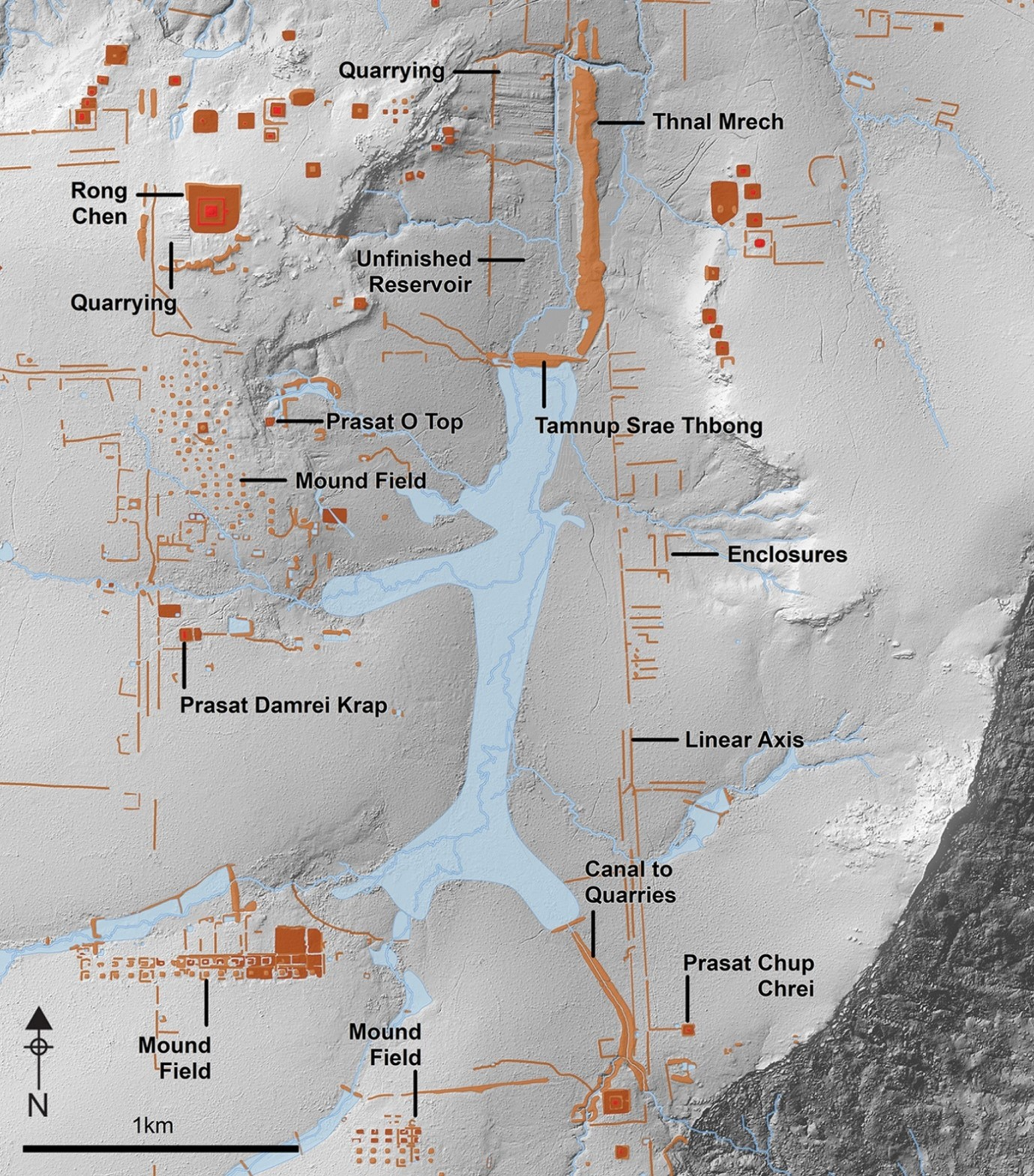
Figure 4. Map showing detailed results of archaeological lidar survey (aerial laser scanning) of the southern sector of Mahendraparvata, courtesy of Damian Evans.
Most models of urban and state formation in Asia, including those that treat water control as a central factor in the emergence of the state, envisage all urban and political transformation taking place on the lowland plains.Footnote 47 They rarely consider the possibility that highlands and mountains played an important role in the early emergence of states and the development of urbanism.Footnote 48 Such models have often regarded the later lowland city of Angkor as the apex form of the complex hydraulic bureaucratic state. However, the society that later produced the Khmer empire was apparently testing out urbanism, statecraft, and water management in their mountain city of Mahendraparvata, long before the urban and political pattern of Angkor had fully crystallized on the plains.
In addition to hosting one of the earliest cities of the Khmer empire, and functioning as the source of water for the emerging Khmer capital of Angkor, the Kulen mountains were also the location of quarrying and crafting activities.Footnote 49 The largest ceramic production site in the region was located in the Kulen mountains.Footnote 50 One reason for this may be that firing pottery required a plentiful supply of timber that could be sourced from the mountain. Other industries were present too, such as sandstone quarries in the southeast part of the Kulen mountains that provided stone for the city of Angkor.Footnote 51 Material, resources, and people moving between the Kulen mountains and the Angkorian plain played an essential role in the emergence and growth of the city of Angkor, as well as the production of state architecture and day-to-day domestic pottery. Rather than being inimical or resistant to the civilization of the lowland state, therefore, the Kulen mountain communities were vital to its flourishing.Footnote 52 The Kulen mountains present a striking example of a symbiosis between lowland and highland communities that led to recognisably state-like features in the landscape and in the historical record. These collaborative state-building activities were connected through temple networks and collective participation in water management and irrigation, a phenomenon found elsewhere in Southeast Asia, such as in Bali.Footnote 53
Volcanoes of central Java, Indonesia
Java is an island of volcanic mountains that run from east to west, with over 145 million people living on landmass smaller than Great Britain or the South Island of New Zealand. Java is the economic and political centre of Indonesia, the largest and most populous country in Southeast Asia. Criss-crossing between its mountains are rivers and patchworks of valleys and plains. The island has a rich archaeological record and a long tradition of history writing, but despite this, it has largely fallen out of global history.Footnote 54 As in other parts of the world, historians of Java have focussed on the lowland states centred on royal courts, which are tied to monumental architecture and the inscriptional record. For example, the famous temples of Borobudur and Prambanan, located in central Java, are associated with the kingdom of Mataram (eighth–tenth century CE). This emphasis on lowland states has resulted in a significant neglect of the history of Java’s highland regions.Footnote 55 This is a missed opportunity because the island’s volcanoes offer archaeological, textual, and architectural evidence that attests to very diverse forms and processes of social development and transformation (see Figure 5).

Figure 5. Composite satellite image rendered over a three dimensional landscape model of the volcanoes of central Java, including peak altitudes, created by the authors.
The Dieng plateau in central Java is a marshy volcanic caldera that rises more than two kilometres above sea level. This sublime landscape, often misty from the clouds and volcanic gases, now contains nine standing shrines with Hindu characteristics (see Figure 6). Though there has been much debate over the precise chronology of the temples’ construction, they can be dated approximately to the seventh or eighth century CE, thereby offering some of the earliest examples of monumental religious architecture in Java.Footnote 56 The temples at Dieng were first described by Europeans in the early nineteenth century, when the area was being converted for agriculture. Thomas Stamford Raffles, the Lieutenant-Governor of Java during the British interregnum of 1811–16, claimed that the foundations of hundreds of temples, linked by a network of roads, could be identified in the local area.Footnote 57 The few surviving temples may represent a tiny proportion of the extent of the original site; only two percent of what once existed, if Raffles’ estimate is accurate. These temples exhibit ‘an amalgamation of architectural motifs found across south India at this time with local stylistic elements which make them uniquely Javanese’.Footnote 58 These buildings thus indicate a precocious architectural tradition in highland Java that developed in dialogue with other Asian cultures.

Figure 6. Temples on the Dieng plateau, at an altitude of over two thousand metres (photo by Midori, Wikimedia Commons).
Recent archaeological excavations in the Dieng plateau have provided new evidence that the area was linked to long-distance maritime networks of the late first millennium CE. Excavations yielded a variety of Tang-dynasty Chinese ceramics, including the distinctive three-colour Changsha ware that was found in abundance on a ninth-century shipwreck discovered off the coast of the nearby island of Belitung.Footnote 59 Excavators also found a sherd of lustreware that most likely originated from the Persian Gulf, which indicates that goods were travelling across the Indian Ocean to reach the Dieng plateau at this time. According to the excavation report, the ‘proportion of foreign ceramics in [this] highland site far from the coastal ports or other ceremonial sites … is surprisingly high’.Footnote 60 Such a find is only surprising if one has a preconceived notion that highland communities should be isolated and lack access to foreign goods. The evidence instead shows that Dieng was very much a globally connected place.
Excavations revealed occupation of the Dieng plateau for many centuries, as well as the existence of infrastructural links with lowland areas. Alongside the Chinese ceramics were found earthenware utensils used for everyday and ritual purposes. Many of these utensils have counterparts in modern Indonesian homes, such as water pouring and storage vessels, mortars for grinding, stoves, frying pans, cooking pots, and storage jars. The presence of these objects at a wide range of stratigraphic levels demonstrates that people were cooking and storing food on the Dieng plateau, a pattern consistent with settled habitation, at least intermittently if not permanently. These earthenware objects belong to the general repertoire of Javanese pottery types from the seventh to tenth centuries, indicating that the region was closely linked to the communities of the lowlands and the coast.Footnote 61 These linkages are confirmed by several long premodern stone staircases, constructed along the northern and southern access routes to the plateau, each of which numbered over a thousand steps when they were first described in the early nineteenth century.Footnote 62 Far from being isolated from lowland state communities, the Dieng plateau was connected to them through major infrastructure works designed to facilitate transport across steep gradients. These staircases thus represent a concerted effort to reduce the ‘friction of terrain’ that Scott cites as a major inhibiting factor for transport, which thereby limits the reach of states into the highlands.Footnote 63
The presence of written texts is often treated as a tell-tale sign of state presence and political organization.Footnote 64 Premodern inscriptions concerning the Dieng plateau challenge the assumption that highland communities in Southeast Asia were non-literate societies that were isolated from the state.Footnote 65 Instead, they indicate that Dieng was intimately linked to the cosmopolitan culture and agricultural system of the lowlands.Footnote 66 The toponym ‘Ḍi Hyang’, an older form of ‘Dieng’,Footnote 67 appears in inscriptions issued between the mid-ninth to the early tenth century CE, both on the plateau and elsewhere in Central Java.Footnote 68 Several of these inscriptions acknowledge the authority of a monarch or a high aristocrat of the Mataram kingdom, which is known to have been centred in the plains around Yogyakarta. The oldest known inscription bearing a legible date is a stone stele engraved in 854 CE, which records that a noble called Vīrāja bestowed an endowment of agricultural land to a monastery.Footnote 69 Religious institutions at Dieng were served by villages at lower-altitude regions, as is shown in the Gunung Wule inscription (861 CE).Footnote 70 The latest inscription at Dieng was painted on a mountain crag in a beautiful ornamental script, bearing the year 1132 of the Śaka era (equivalent to 1210 CE, see Figure 7), though the paint has now faded away.Footnote 71 These written traces demonstrate that rather than evading or resisting the administrative tendencies of the lowland state, therefore, the people of the Dieng plateau were actively involved in them. As many of the Dieng inscriptions remain only partly deciphered and translated, they represent a highly promising avenue for future research on highland–lowland relationships in premodern Java.

Figure 7. Painted inscription at Dieng, photographed by Isidore van Kinsbergen circa 1864.
Written literature was far from alien to the highland Javanese. A hundred kilometres east of the Dieng plateau are two large volcanoes, Mount Merapi and Mount Merbabu, which rise to an altitude of three kilometres above the surrounding plains. These mountains have yielded a vast array of manuscripts dating from the sixteenth to the eighteenth centuries CE, the most significant group of which is a collection of palm-leaf texts that reportedly once belonged to a Javanese priest called Windusana. This prolific collector, who lived in the late eighteenth century, is reputed to have owned over a thousand manuscripts. The colonial Batavian Society of Arts and Sciences acquired the Merapi-Merbabu manuscripts in 1852, of which approximately four hundred are currently held in the National Library of Indonesia.Footnote 72 The majority remain unstudied. Partly because the manuscripts were regarded as peripheral mountain texts, and are not associated with any well-known European collector, the surviving documents have become dispersed across the National Library of Indonesia’s collection and through other collections across the world.Footnote 73
The Merapi-Merbabu collection goes back to the mid-sixteenth century, which makes it significantly older than other major collections of Javanese manuscripts.Footnote 74 Despite their old age and distinctive features, these mountain texts have until recent years received little scholarly attention compared to the later corpus of historical material that has survived in lowland areas.Footnote 75 Many of the manuscripts in this collection use a unique variant of the Javanese calendar system.Footnote 76 The materials are diverse in their subject matter, which includes history, religion, politics, poetry, lexicography, and magic. They exhibit a variety of different languages and scripts associated with Buddhism, Hinduism, and Islam. The majority of them use a writing system known today as ‘mountain script’ (aksara gunung) (see Figure 8). In addition to the Javanese language, both Sanskrit and Arabic appear as scriptural languages among the Merapi-Merbabu manuscripts.Footnote 77 Some manuscripts show linguistic mixing, with the appearance of Arabic loanwords in Old Javanese texts.Footnote 78 The Merapi and Merbabu mountain communities thus belonged to a multi-lingual and multi-religious milieu. The colophons of the manuscripts indicate that they circulated widely among mountain communities throughout central Java. These scholars and scribes were engaged with the world around them, including the court centres near modern-day Yogyakarta and Surakarta.

Figure 8. Detail of a palm-leaf manuscript from the Merapi-Merbabu highland region, held as Malayo-Polynésian 165 in the National Library of France.
Mountain communities in Java, like those elsewhere in Southeast Asia, are often depicted by scholars as resisting and rejecting the influence of lowland states. According to the conventional view, high mountain slopes were not the kind of place where one would expect to find a thriving textual tradition. This view also tends to regard lowland coastal port cities as being more cosmopolitan and culturally diverse than mountain communities. The Merapi-Merbabu manuscripts belie this stereotype, by showing that the central Javanese highlands were places that embraced literacy and took an inclusive attitude towards cultural diversity and new trends. Mountain communities of the early modern period are often imagined as holdouts of Hindu-Buddhist religion and culture, against the spread of Islam out of the port cities of the island’s north coast.Footnote 79 The Merapi-Merbabu manuscripts show instead that their mountain scribes and owners took an interest in both Islamic and non-Islamic materials, with no apparent religious tension. Rather than being conservative and resistant to outside influence, the mountain communities of Merapi and Merbabu exhibited openness to diversity and novelty. The distinctive features of these manuscripts show that the people of Merapi and Merbabu did not shun or flee from lowland civilization, but selectively absorbed novel cultural influences in creative ways.
Ifugao Highlands, the Philippines
We now turn from the Indonesian archipelago, along the southern margin of Southeast Asia, to the Philippine islands in the northeast. The island of Luzon is located at the northern end of the Philippines. Luzon is the demographic, economic, and political centre of the country, with the capital city of Manila at the centre of the island. The northern part of Luzon is rich in archaeological finds and cultural heritage, including the recently discovered hominin Homo luzonensis, and two UNESCO World Heritage Sites: the Spanish colonial town of Vigan and the Ifugao Rice Terraces in the highlands. Running from the northern tip of Luzon is an expansive mountainous region known as the Philippine Cordillera, the biggest and largest mountain chain in the Philippines. The Cordillera stretches 320 kilometres north to south and over one hundred kilometres east to west, and it is one of the most ethnically and linguistically diverse parts of the Philippines.
High up in the Cordillera are the rice terraces of the Ifugao people (see Figure 9). The Ifugao rice terraces are one of the most visually impressive heritage landscapes in Southeast Asia. But early scholarship and popular depictions of the Ifugao have treated them in a racist manner, as a window into a lost primitive society, a symbolic caricature of the Philippines’ prehistory. The Ifugao were regarded as a highland community utterly separate from the outside world, and were often framed by American anthropologists and archaeologists as practicing an unchanging and static culture.Footnote 80 Their historical practices of tattooing, weaving, and headhunting were often highlighted.Footnote 81 The Ifugao are often mentioned among examples of what Southeast Asian highland communities ‘should be like’, and they were frequently cited by Scott as a canonical example of upland peoples evading the reach of lowland state oppression. For example, he repeatedly used ethnographies and histories of the Ifugao to substantiate theoretical arguments for which he lacked examples in mainland Southeast Asia.Footnote 82 Images of the Ifugao highlands even appear on the front cover of Indian and other Asian editions of The Art of Not Being Governed.Footnote 83

Figure 9. Map and photograph of the Ifugao rice terraces, courtesy of Stephen Acabado.
The last decade of archaeological research, led by the Ifugao Archaeology Project, presents the Ifugao in a very different light. The findings indicate the presence of a non-state society, engaged in sedentary agriculture and rice irrigation on a truly monumental scale, which involved sculpting valleys and mountainsides over many tens of kilometres. They represent a vast amount of planning, specialized knowledge, labour organization, and large-scale alignment of economic behaviour.Footnote 84 These monumental terraces were constructed by the Ifugao people’s ancestors and, as a living tradition, they continue to be built and maintained in the present day. The terraces constitute landscape engineering on an immense scale, eclipsed only by colossal modern infrastructure projects such as the Three Gorges Dam in China or the Panama Canal. These terraces were previously thought to have been built over thousands of years, but the Ifugao Archaeology Project has revealed that the terraces switched to irrigated rice and underwent major intensification, extensification, and upscaling in the period following the Spanish invasion of the Philippines in 1565. Spanish domination of the lowland communities in Luzon is now thought to have resulted in refugees from these zones relocating into highland communities such as that of the Ifugao. The Ifugao absorbed these communities of refugees and scaled up their agricultural system to an enormous size. This provided more food and enabled them to resist Spanish colonial forces for most of the colonial period.Footnote 85
The terraces, villages, and swidden fields fill many tens of kilometres of mountain slopes across north-central Luzon. Here the terraces cover an area of about sixty square kilometres in aerial extent. However, given the extremely steep nature of the landscape, the actual surface area covered by terraces is significantly larger. The altitude of the terraces varies, beginning at six hundred metres above sea level and rising up to an elevation of 1,500 metres above sea level.Footnote 86 In more recent times, the population density of the terraced region was roughly three hundred people per square kilometre, a similar settlement density to the modern agglomerations of Canberra in Australia, Nay Pyi Taw in Myanmar, or Milton Keynes in the United Kingdom. The focus of the terraces are villages and hamlets which range in size from forty to one hundred households.Footnote 87 Most villages are located in a line of sight of nearby villages situated up and down the valley. One square kilometre may contain up to forty villages and hamlets of varying sizes. Fields and terraces are built on top of the landscape using many complicated layers of stones and gravel, as well as mud and soil of different viscosities.Footnote 88 The fields are used to grow rice and a variety of other crops such as sweet potato outside of the rice season. Amphibians and fish also populate the terraces, in turn controlling pests and providing additional protein.Footnote 89 The fields and terraces are faced with stone. Wide terraced fields at the bottom of the valleys rise up the hillsides, turning into narrow and steeply terraced field strips at higher altitudes. Areas that are too steep to terrace are used for agroforestry and woodlots. Mountain summits remain forested to mitigate erosion and maintain the health of ground water. Often fierce rocky mountain streams twist along the valley floor, joined by irrigation streams that flow from the mountaintops down through the terraces (see Figure 10).

Figure 10. Ifugao terrace landscape organisation, courtesy of Stephen Acabado.
The Ifugao Archaeology Project has uncovered many important physical clues to the history of this mountainous landscape and its people.Footnote 90 Excavations conducted at the village of Old Kiyyangan between 2012 and 2015 uncovered stone-lined irrigation channels, as well as domestic household debris dating back to 1050 CE.Footnote 91 This debris included earthenware pottery shards, some of which came from cooking pots. Analysis of the potsherds revealed that, prior to 1300 CE, the community mostly consumed starchy crops including taro, yam, and breadfruit.Footnote 92 These were likely grown in much smaller scale terraces.Footnote 93 Animal bones have also been found, consisting mostly of deer and pig.Footnote 94 Evidence of rice cultivation at the site coincides both with an expansion of the village community and the earliest years of Spanish colonization in the middle of the sixteenth century.Footnote 95 This has led archaeologists to hypothesize that the adoption of rice farming may have involved the adaptation and intensification of lowland technologies to the highland conditions of Ifugao. These agricultural innovations allowed the highland communities to successfully resist Spanish colonization for longer than their lowland counterparts, all the while developing the kind of wet-rice agriculture that Scott has claimed to be especially characteristic of lowland state societies.Footnote 96
The Ifugao terraces constitute social collaboration, labour organization, and economic synchronization on a colossal scale, producing one of the most monumentally engineered landscapes in the pre-industrial world. The Ifugao communities would not generally be considered a state, and they do not have a tradition of monarchical bureaucracy as found in lowland Southeast Asia. However, these communities were able to cooperate and coordinate activity to maintain a high degree of independence throughout the Spanish colonial period, while most lowland polities in Luzon, many of them monarchical, were subjugated.
At first glance, the Ifugao case might seem to support Scott’s basic intuition, for there were indeed state-resisting communities in the highlands of the Philippines. But the problem in Scott’s argument is the agro-ecological mechanic that he proposed as underpinning this resistance to the state. According to this mechanic, particular kinds of agriculture determine the types of social system that can emerge in a given historical context. Irrigated rice farming is considered the prerogative of states and is generally associated with the plains, while other crops like taro, sweet potato, as well as non-irrigated (‘dry’) rice cultivation, are considered far less susceptible to bureaucratic control and appropriation by the state.
The Ifugao are an important example of a community that successfully resisted being subjugated by the colonial state, but they did so with a totally different political economy than Scott envisaged. Intensive irrigated rice agriculture was not merely compatible with the Ifugao’s ability to resist colonialism; it may have actually strengthened that resistance. The weakness of Scott’s model here stems from its assumption of a Braudelian highland uniformly opposed to social complexity, coupled with an agro-ecological determinism that takes for granted that certain types of agriculture (like irrigated rice farming) necessitate certain kinds of governance (like bureaucratic states).Footnote 97 We now know that irrigated rice agriculture is not necessarily a state prerogative, but can support communities in their resistance to state encroachment. With growing global interest in egalitarian social organization, an important question for future research is whether such state-resisting societies may be far more common and arise more easily through a wider range of mechanics than Scott proposed.Footnote 98
Neither Braudel nor Scott’s notions of what highland communities are ‘meant to be like’ can account for the archaeological record in the Philippine Cordilleras. The Ifugao highlands were not anarchic-egalitarian utopias, as Scott envisaged, nor were they static, isolated, and unchanging societies devoid of social organization and transformation, as Braudel might have imagined. The absence of state structures in these highlands did not stifle or restrict economic development. These were intensive agricultural communities, with a history of adaptation, invention, social cooperation, and synchronization of economic behaviour on a huge scale. The Ifugao highlands are a place where an extensively connected community were experimenting, re-imagining, and re-engineering their landscape and social possibilities, in ways that go beyond both Scott’s description of flight and dispersal and Braudel’s view that civilization cannot climb mountains. Here in the Ifugao highlands, archaeology is revealing a pattern of resistance to Spanish colonizers, followed by or simultaneous with social coordination and agricultural intensification and extensification on a giant scale. This landscape occurs not on the coast or in a river delta, built by communities that engaged with South Asian ritual and religion, held together by the charisma of a great monarch, but in the stateless highlands of the Ifugao people.
Conclusion
Historians, archaeologists, and researchers in many other disciplines have long viewed mountains and highlands merely as a foil to the lowlands. This is a common thread that links scholars of different ideological and disciplinary persuasions. For Braudel, mountains were a vertical barrier to the great waves of civilization. He saw urban and sedentary life as characteristic of the lowlands, as a result of which the highlands were excluded from the achievements of civilization. For Scott, mountains were places of sanctuary from state domination and were home to egalitarian, non-coercive forms of social organization. Rather than condemning the highlands as backward, Scott celebrated their autonomy and separation from lowland state control. However, underlying the difference of perspective between Braudel and Scott is the same basic premise: that highland environments limit and constrain social complexity, and hence are inhospitable to characteristics often identified with civilization and state structures.
To claim that one causal process generated a particular historical outcome may be regarded as a misfortune; to assume the same for diverse outcomes looks like carelessness. When trying to understand mountains, Braudel and Scott attributed their phenomena of interest to one causal mechanic, a single fundamental process. In each of the case studies we have described, there are any number of underlying mechanics and interactions at play. We have shown that Southeast Asian highlands possessed various combinations of the five features that highlands are conventionally supposed to lack: urbanism, state societies, irrigated agriculture, cosmopolitan culture, and long-range connectivity. These played a part in the diverse outcomes evident in the historical and archaeological record. The Kulen mountains were intimately connected to the early Khmer state, providing a setting for early experiments in urban planning, water management, and ultimately an indispensable resource base for the monumental city of Angkor. They may also have provided early defensive advantages for the Khmer state that would later conquer and incorporate large parts of mainland Southeast Asia. In Java, highland communities interacted with a wider world through various kinds of spiritual, symbolic, and material exchanges. These communities engaged deeply with the scriptural traditions of Hinduism, Buddhism, and Islam, and they were key carriers of Javanese knowledge. On the Dieng plateau and in the Merapi and Merbabu mountains, the Javanese gathered texts and ceramics from as far afield as China, India, and the Middle East. The Ifugao highlands present yet another picture. They provided a place of safety from subjugation by Spanish colonization, but also a location for monumental re-engineering of the landscape for rice agriculture. A sophisticated project of agricultural engineering developed there, which supported a productive irrigated rice economy, a substantial population, and a thriving culture.
Many scholars have focussed on what mountains mean in relation to lowlands and have categorized the relationship in the same deterministic way. We suggest that, just as highland communities are varied, so too are their relationships with the lowlands. In fact, none of the highlands discussed here have the same kind of relationship with their neighbouring lowlands. In some cases, the mountains are the incubator of innovation and invention, while the lowlands are racing to catch up. In others, mountains are the preservers of historical textual sources and provide knowledge about early state activity. Just as there are many kinds of archaeological outcomes in the mountains, so too are there many causes for diversity, some that we know and perhaps many that we are yet to identify. Societies with mountains and highlands have a range of possibilities open to them that may not be present in the lowlands. Mountains and highlands are not developmental dead ends, nor cartographic cages that lock their societies into a single historical path.
Mountains and highlands present unique kinds of challenges to the people who live with them. The ways in which these people persist, overcome, and find ways to live with the challenges of mountains helps to explain the dramatic diversity we find in the highlands. Landscape and ecology sculpt and shape strategies for living, but they do not determine the diversity of form.Footnote 99 The process of people finding ways to live and flourish with mountains and highlands involves close engagement and experimentation with landscape.Footnote 100 It is this correspondence of people with mountains that enables the creativity, transformation, and diversity that we observe empirically.Footnote 101 We propose the phrasing ‘people with highlands’ in place of ‘people in highlands’ to articulate the mutuality and reciprocity of the relationship between societies and the landscapes they interact with. This shift of perspective allows us to see mountains and highlands as open and creative spaces bubbling with historical and archaeological potential, not to be pigeonholed and dismissed as one generic sort of place. People with highlands can transform their societies in any number of diverse ways and at many different scales of action, which cannot be reduced to a deterministic relation between environment and social organization. This is important and exciting as it means that we do not yet know all the things that people and mountains can do together.Footnote 102
We chose three examples of highland sites in this article. But there are many more we could have examined, and each would have given a different picture of the diversity of communities living with highlands and mountains. The arguments presented here have implications for histories of all kinds of landscapes around the world. The traditional neglect of highlands by scholars means that there are likely to be many more major discoveries and surprises waiting in these regions. In Southeast Asia, well-known examples of highland regions include the Tana Toraja in Sulawesi, the volcanoes of Bali, the highlands of western and eastern Java, Sapa in Vietnam, Chiang Mai in Thailand, the Barisan mountain range of Sumatra, and Mount Popa in Myanmar. Around the world, there are many other sites and regions that could yield interesting future comparisons. These sorts of considerations are relevant wherever large communities of people are present, living, and collaborating in highland environments, such as in the Himalayas, Central Asia, Ethiopia, the Middle East, Mexico, the Andes, and the European Alps (see Figure 11).Footnote 103

Figure 11. Sites and regions for potential further comparison and discussion, created by the authors.
Previous scholarship has presented each of these Southeast Asian examples as an anomaly, a supposed exception that proves the rule that highlands are places of limitation and constraint. But when taken together, these anomalies present an altogether different image of highland Southeast Asia. Rather than a homogeneous negative image of the lowlands or a uniform Zomia region, mountains supported a great diversity of rich, connected, experimental, and collaborative societies. The highlands were not all one sort of place, deterministically fated by their high altitude to be separate to the lowlands. Their societies were not, as Scott argued, ‘the inescapable “dark twin” of state-making projects in the valleys’.Footnote 104 Instead, they were places of opportunity, creativity, and growth. The highlands are not a world apart, but they were and continue to be a diverse and integral part of the world.
Do mountains kill states? Or to put it more precisely: can people with mountains kill states? To be sure, people with mountains can resist states, and can do so in many more ways than scholars have yet imagined. But this is only part of the story, because people with highlands and mountains can also create and consolidate states that are just as robust as those of the lowlands. They can preserve material and textual traces of states, and they can create forms of social organization that we do not yet have an analytical terminology for. By returning to the empirical field of Zomia, the highlands and mountains of Southeast Asia, we discover how recent historical and archaeological evidence reveals the dramatic possibilities of diversity and transformation for people with highlands.
Acknowledgements
The authors thank the following people for their feedback on drafts of this article: Chris Gosden, Anke Hein, Ian Forrest, Adrian Vickers, Roland Fletcher, Amy Bogaard, Damian Evans, Stephen Acabado, and the two reviewers. We would also like to thank the staff of Queen’s College Library Oxford, Magdalen College Library Oxford, and the British Museum Asia Reading Room. Michael Leadbetter received research funding from the University of Oxford's Clarendon Scholars Fund, and the Cyril and Philis Long Fellowship in Social Sciences at The Queen’s College Oxford. Wayan Jarrah Sastrawan’s contribution to the present publication is a result of the project DHARMA ‘The Domestication of “Hindu” Asceticism and the Religious Making of South and Southeast Asia’. This project has received funding from the European Research Council (ERC) under the European Union’s Horizon 2020 research and innovation programme (grant agreement no 809994). This article is dedicated to the memory of Damian Evans, our brilliant and generous colleague.
Michael Paul Leadbetter is Lecturer in Archaeology at Magdalen College, and a Clarendon Scholar in the School of Archaeology at the University of Oxford. Michael teaches Archaeology and Anthropology at Oxford, and holds the Cyril and Philis Long Fellowship in Social Sciences at The Queen’s College Oxford. Michael is a researcher on the ‘Sites at the Intersection of Cultural and natural Heritage’ project (SXNCH) based in the Oxford School of Geography and the Environment. Michael researches the long-run development of urbanism in Southeast Asia and globally, celebrating its diversity and creative transformations. He pushes the boundary between Archaeology and the Social Sciences, with cross-disciplinary research using archaeological data to test the empirical basis of political-science models. Recently Michael’s interdisciplinary research has focused on the transforming relationship between Archaeology and Natural History, with implications for understanding human adaptation to climate change.
Wayan Jarrah Sastrawan is a historian specialising in the premodern history of Indonesia. He is a postdoctoral research fellow at the École française d’Extrême-Orient (Paris), and a research affiliate at the University of Sydney. He is especially interested in using indigenous Southeast Asian sources to rethink how history is practised. Jarrah has written widely on Southeast Asian history in leading history and area studies journals. He has written on his research for New Mandala, The Conversation, Inside Indonesia, as well as blogs of the British Library and Malay Heritage Centre. He has given public talks, seminars, and national radio interviews on his research, and has an active outreach program on traditional and social media. His current research project, funded by the European Research Council, focusses on the development of social institutions and state formation in eighth- to tenth-century Java.


 Open access