


From the perspective of how people experience cities and why they want to stay in them, the degree of inequality looms large for many reasons. On the one hand, wealth enchants (Geertz Reference Geertz1980:123). People may find cities attractive because of the possibility of obtaining wealth. This line of thought runs deep in discussions of urbanism (Wirth Reference Wirth1938) and echoes claims of cities as social and economic reactors (Bettencourt Reference Bettencourt2007; Glaeser Reference Glaeser2011). On the other hand, greater inequality may result in more social dysfunction (Stiglitz Reference Stiglitz2012; Wilkinson and Pickett Reference Wilkinson and Pickett2009). The city loses stability as poor people may see through the enchantment of riches and question why they are participating in a social system that benefits other people much more. How extreme was inequality at the ancient Maya city of Coba, Quintana Roo, Mexico?
Coba is an outlier in this Compact Special Section of Ancient Mesoamerica since all other articles focus on sites from the Southern Maya Lowlands. Yet systematic data on inequality are available from other Northern Lowland sites (Figure 1). We compare Coba to these other sites to address changes in inequality over time and the relationship between forms of governance and inequality. Furthermore, close examination of the shape of Lorenz curves at Coba and other cities allows us to challenge dichotomous models of social inequality and explore wealth as a continuum.
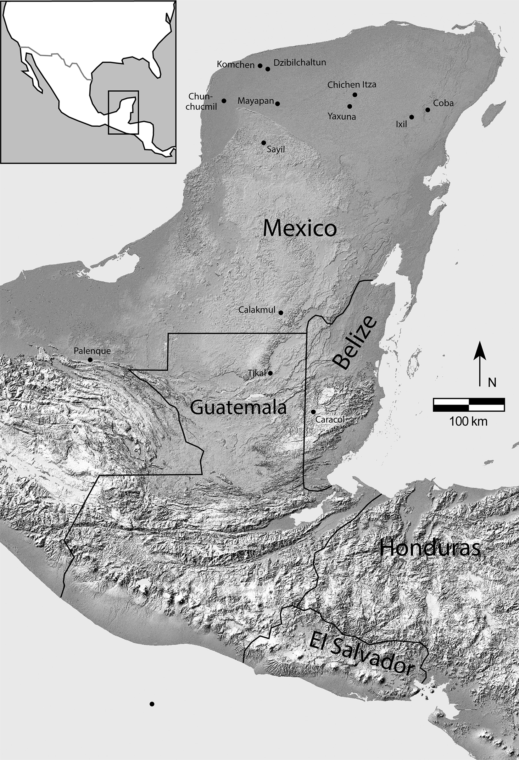
Figure 1. Map showing locations of places mentioned in the text.
Research at Coba began in earnest in the 1970s and has revealed numerous remarkable features (Benavides Castillo Reference Benavides Castillo1981; Folan et al. Reference Folan, Kintz and Fletcher1983; Manzanilla Reference Manzanilla1987). The site has two enormous, monumental architectural groups (the Iglesia group and the Nohoch Mul group; Figure 2) and several other massive compounds connected by a network of intra-site causeways. The combined length of these causeways is approximately 36 km (not counting those portions of the Yaxuna and Ixil inter-site causeways that lie beyond the site boundaries), second only to Caracol. Coba has more carved stelae than any other site north of Calakmul. These carvings portray an Early to Late Classic dynasty whose members employed the kaloomte' title (Esparza Olguín Reference Olguín and Octavio2016; Guenter Reference Guenter and Stanton2014). We have used LiDAR data to show that the site covered approximately 77 km2 and, depending on which methods of calculation are used, reached a peak population of between 60,000 and 90,000 during the Late Classic period (Stanton et al. Reference Stanton, Hutson and Ardren2022), making it the second largest Classic period Maya site, trailing only Caracol (Chase et al. Reference Chase, Chase, Chase and Chase2022). As seen in a few other densely settled cities in the Northern Maya Lowlands, many residential compounds at Coba took the form of houselots encircled by low stone albarrada walls (Dine et al. Reference Dine, Ardren, Fisher and Smith2023).
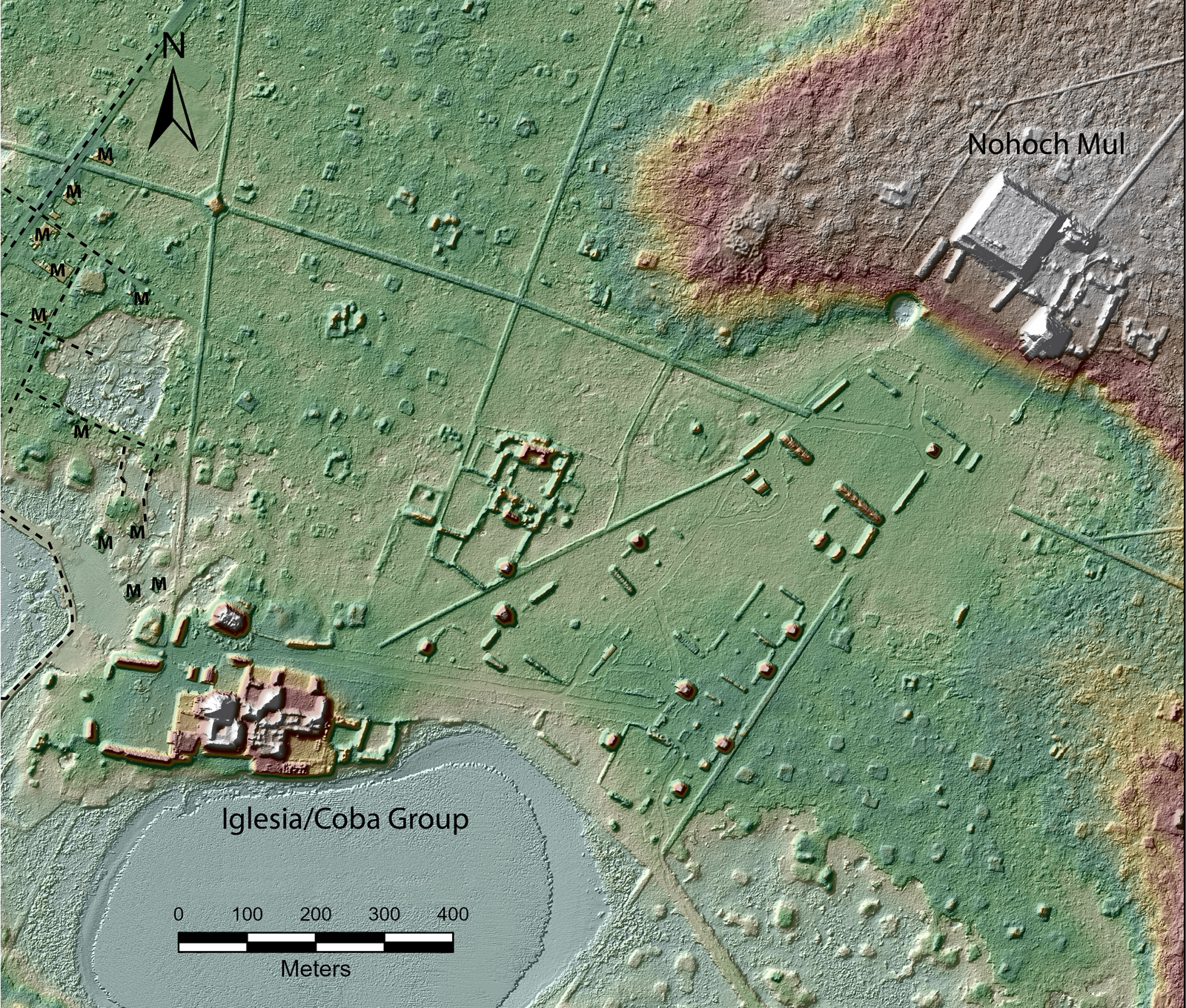
Figure 2. Coba site center. The modern village of Coba is located at the far left of the figure. Modern roads in the village are marked with dotted lines. Modern buildings are marked “M.”
Measuring inequality
Inequality takes many forms. Archaeologists often parse inequality using broad categories such as status (which includes genealogical pedigree and control of sacred knowledge), wealth (which includes control of land and portable and non-portable goods), and capabilities (which include social networks and livelihood skills) (Chase and Chase Reference Chase, Chase, Chase and Chase1992:7; Hutson Reference Hutson2016; McAnany Reference McAnany, Sabloff and Henderson1993; Munson and Scholnick Reference Munson and Scholnick2022). Material wealth is the easiest to measure, and architecture is often the only dataset available for assessing wealth at extensively mapped cities with thousands of residential groups. Luckily, architecture is one of the best proxies for wealth because it is “relatively permanent, functional and not merely symbolic and furthermore not subject to the vagaries of gift, offering, payment, loan, accident, and disposal that conceivably explain the recovered distributions of portable items” (Tourtellot et al. Reference Tourtellot, Carmean, Sabloff, Chase and Chase1992:81; see also Smith Reference Smith1987). In particular, Wilk (Reference Wilk1983) presented a Maya ethnographic study in which surface area of houses correlates with wealth. Volume works even better as an index of wealth, since it captures the costs of material and labor more accurately (Smith et al. Reference Smith, Dennehy, Kamp-Whittaker, Colon and Harkness2014:312) but depends on occupational length (see Hutson Reference Hutson2016:151–152, Reference Hutson, Hutson and Ardren2020:411–412); two houses with the same surface area may represent very different expenditures if one is built on a voluminous platform and the other is not.
Despite extensive use of architecture as a proxy for wealth in the Maya area and the recent trend of compressing these data into a Gini coefficient (Abrams Reference Abrams1994:77; Arnold and Ford Reference Arnold and Ford1980; Ashmore Reference Ashmore, Wilk and Ashmore1988:161; Becker Reference Becker1973; Brown et al. Reference Brown, Watson, Gravlin-Beman, Liebovitch and Braswell2012; Carmean Reference Carmean1991; Folan et al. Reference Folan, Hernandez, Kintz, Fletcher, Heredia, Hau and Canche2009; Haviland and Moholy-Nagy Reference Haviland, Moholy-Nagy, Chase and Chase1992; Hutson et al. Reference Hutson, Magnoni, Mazeau, Stanton, Mathews and Morrison2006; Kurjack Reference Kurjack1974), the methods harbor both technical and conceptual problems (Basri and Lawrence Reference Basri and Lawrence2020; Hutson Reference Hutson2016:150; see also Munson et al. Reference Munson, Scholnick, Mejía Ramón and Aragon2023). Regarding the latter, the ancient Maya had choices regarding where to invest their resources, and while some households chose to invest in architecture, it is clear that others did not (Hutson Reference Hutson, Hutson and Ardren2020; Sheets Reference Sheets, Masson, Freidel and Demarest2020). Competing values structured decisions about what goals to pursue, and we should not expect a single aspect of culture to accurately reflect a socially nuanced value such as wealth in all cases. Households with similar resources may end up having different amounts of architecture if one household pursued trade, another pursued construction, and a third pursued relations with other-than-human beings. At Coba, dozens of causeways and unique ceremonial architecture at their endpoints, intersections, and along the shoulders stand as evidence that people invested heavily in processions (for linkages between causeways and processions in the Northern Maya Lowlands, see Hutson and Welch Reference Hutson and Welch2021; Ringle Reference Ringle, Grove and Joyce1999). Processions involve costumes, adornments, musical instruments, dance, and preparing food (Ardren Reference Ardren2015). Thus, a singular focus on architecture can reduce some of the richness and unpredictability of social life, providing only one metric (a Gini coefficient) to assess wealth inequality in the past. Multiproxy approaches to understanding wealth differentials are ideal (Chase et al. Reference Chase, Thompson, Walden and Feinman2023; Munson et al. Reference Munson, Scholnick, Mejía Ramón and Aragon2023), and architecture provides a foundation for future comparative analyses.
Methods
Quantifying surface area and volume of construction from residential compounds presupposes a very accurate map of the ancient city. Portions of Coba were mapped by several research projects (Folan et al. Reference Folan, Kintz and Fletcher1983; Gallareta Negrón Reference Gallareta Negrón1981; Garduño Argueta Reference Garduño Argueta1979), but recent LiDAR data collected by the Proyecto Sacbe Yaxuna-Coba cover a much larger swath. Specifically, for this article we used 104 km2 of LiDAR coverage, centered on the monumental core of Coba and measuring approximately 11.8 × 8.8 km. A portion of the LiDAR coverage has been ground-validated by recent pedestrian survey and the use of maps produced by earlier projects. Regarding chronological contemporaneity, excavations show that the vast majority of the residential groups were built in the sixth to eighth centuries a.d., with minimal later reoccupation (Stanton et al. Reference Stanton, Hutson and Ardren2022; see also Robles Reference Castellanos and Fernando1990).
Stanton and co-authors (2020) completed a first round of digitization involving the identification of platforms. For the current article, Hutson and Stanton completed a second, more intensive round of digitization that involved five feature classes. We also grouped individual features into residential groups. We identified architectural features in the LiDAR imagery using a variety of raster data visualizations produced by the Relief Visualization Toolbox (Kokalj and Somrak Reference Kokalj and Somrak2019). The five feature classes include: basal platforms, structures on top of basal platforms, foundation braces on top of basal platforms, structures built directly on the ground surface, and foundation braces built directly on the ground surface (Figure 3). Larger examples of both structures and foundation braces served as residences. The difference between structures and foundation braces can be blurry in LiDAR imagery, but structures include small platforms, whereas foundation braces are simply the remains of stone walls or footings for walls. In LiDAR imagery, the entire surface elevation of a structure is higher than the surface that supports the structure, whereas for foundation braces, elevations along the wall lines are higher than the surrounding surface, but the elevation in the middle of the foundation brace (the middle of the room(s)) is usually level with the surrounding surface. Structures have more volume than foundation braces and represent a larger commitment of labor. The perishable portions of walls and roofs associated with structures and foundation braces are an important investment in labor that, due to their invisibility, cannot be calculated. The distinction between a structure built on the ground and a basal platform is that basal platforms are larger, generally over 100 m2, and contain substantial unroofed space. We created a polygon shapefile for each of the five feature types and digitized the features in ArcMap.
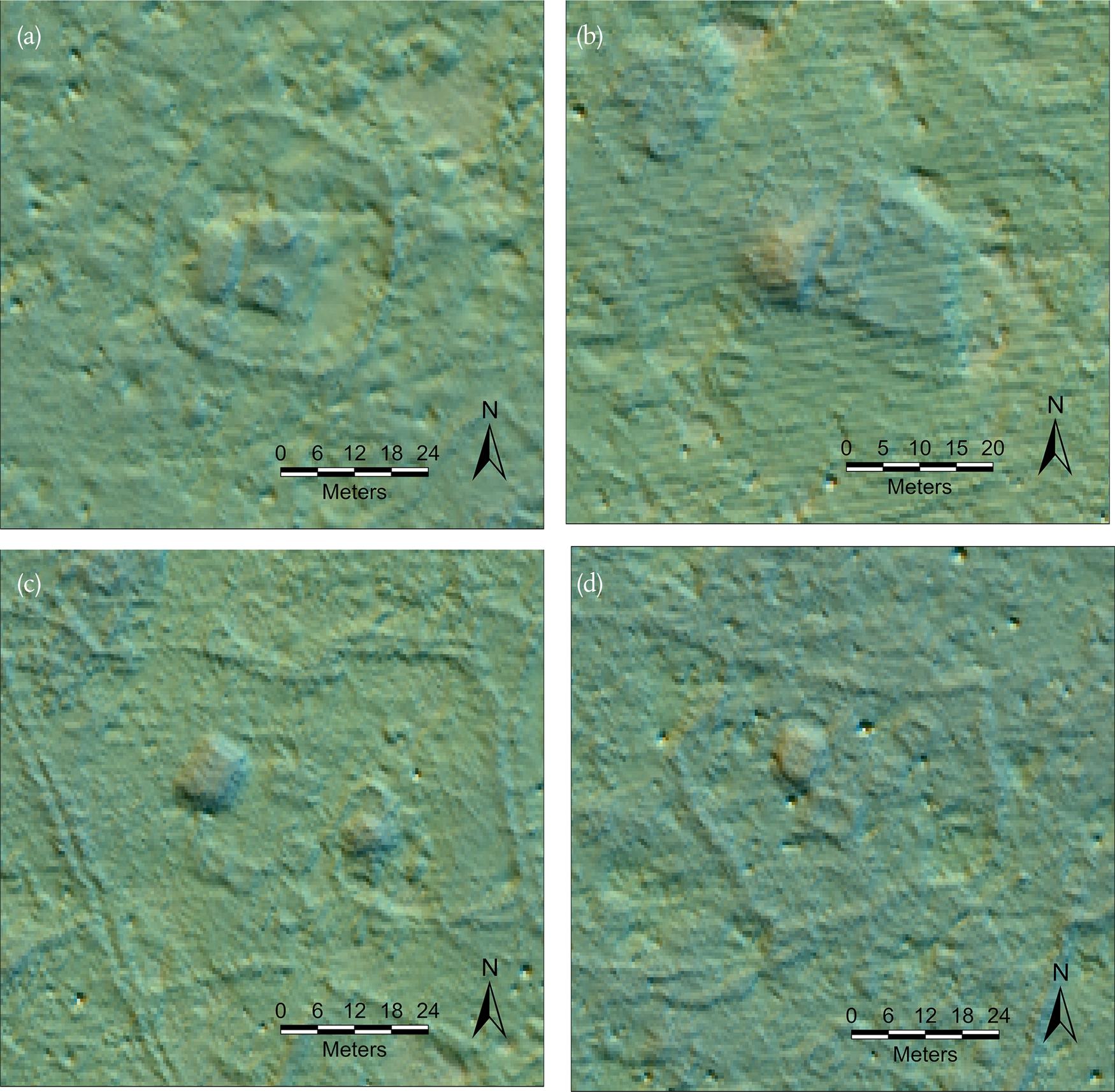
Figure 3. Examples of the five features included in the analysis: (a) a structure and two foundation braces on top of a basal platform (all these features are encircled by a houselot wall); (b) a structure and two foundation braces on top of a basal platform; (c) two off-mound structures and three off-mound foundation braces; (d) an off-mound structure and two off-mound foundation braces.
We measure inequality at the scale of the residential group, occupied in some cases by single family households, and in others by extended family households. We identified 5,969 non-monumental residential groups in the 104 km2 LiDAR block (Figure 4), although at least 200 more groups that pertain to Coba are found near the Coba–Yaxuna causeway to the west, beyond the 104 km2 block. These were not included in our analysis. The most common type of group is a basal platform supporting one or more superstructures. Basal platforms with no visible buildings on top were considered to be residential groups, following the assumption that they supported perishable superstructures that served as residences. Many residential groups at Coba consist of clusters of structures and foundation braces without a basal platform. Table 1 presents summary data on these three types of groups. An isolated structure counted as a residential group as long as it measured more than 25 m2. Single, small (<25 m2), isolated foundation braces or a cluster of two or three small foundation braces were not considered residential groups because we were not convinced that such insubstantial architecture was residential. A large (>25 m2) foundation brace qualified as a residential group as long as it was accompanied by at least one other building. Any cluster of four foundation braces, regardless of size, qualified as a group. The vast majority of small (<25 m2) foundation braces and structures are found within our 5,969 groups and all of these are included in the calculations of volume and surface area. Our sample of residential groups excludes 29 monumental buildings or compounds of buildings that do not appear to be residential, but it does include 22 monumental groups that do appear to contain residences (Figure 5). We quantified inequality both with and without these 22 monumental groups.
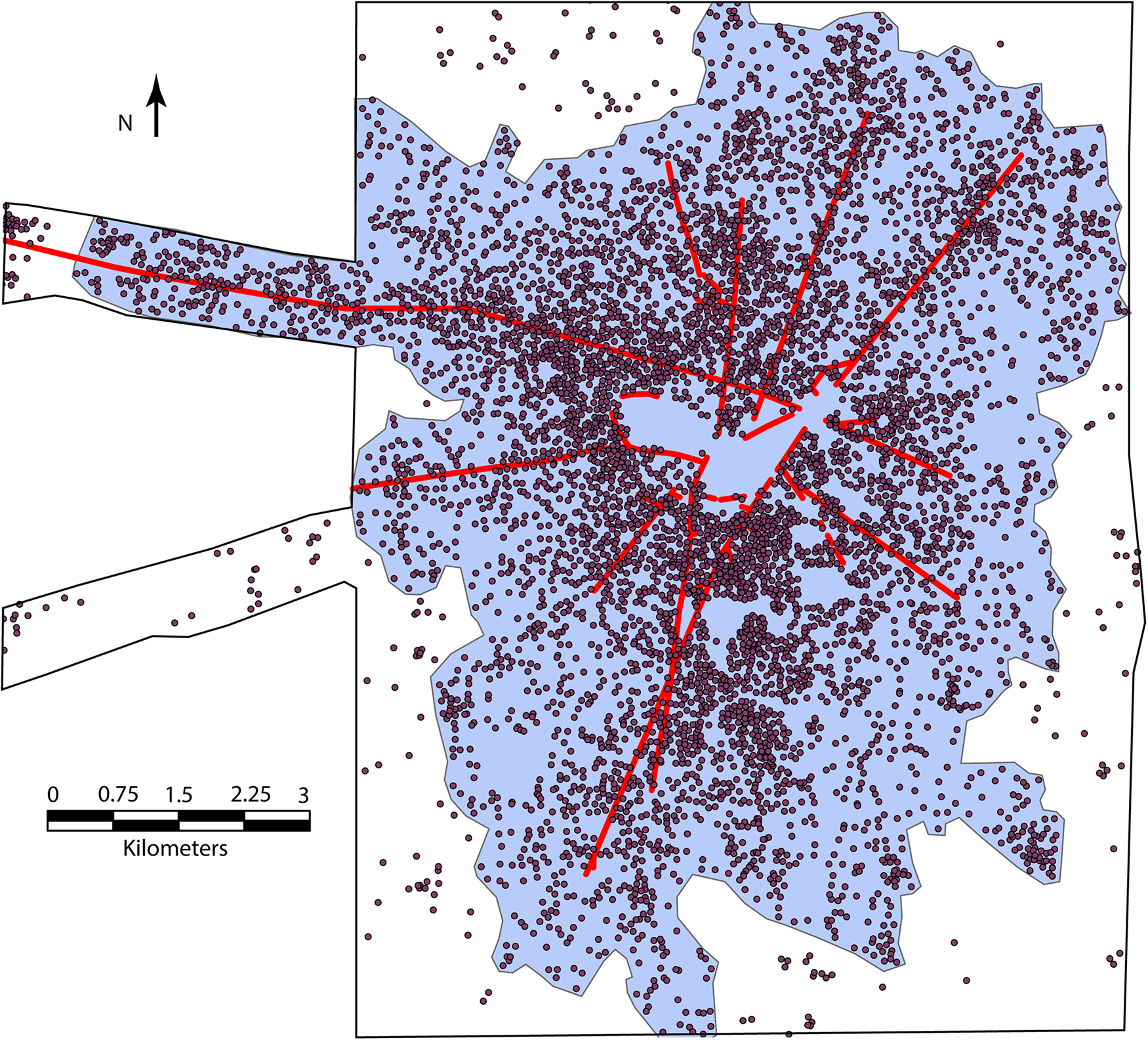
Figure 4. Map of Coba, showing residential groups, as well as major causeways and the site boundary pertaining to the 77 km2 site size estimate.
Table 1. Summary data on non-monumental residential groups.
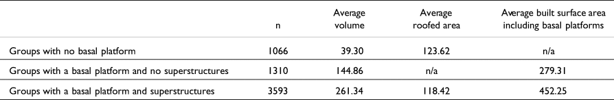
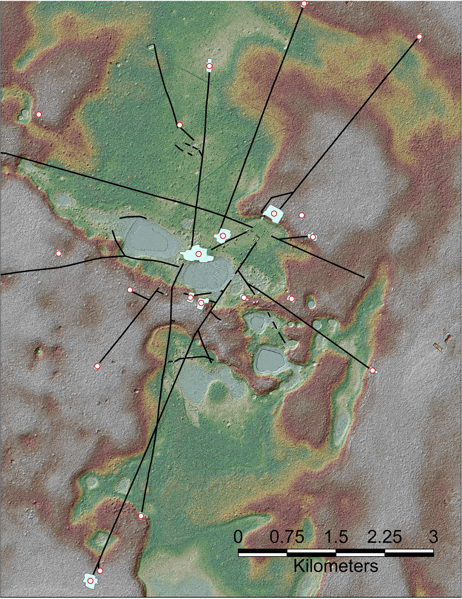
Figure 5. Digital elevation model of Coba, showing causeways and the location of the 22 monumental groups with probable residential occupation.
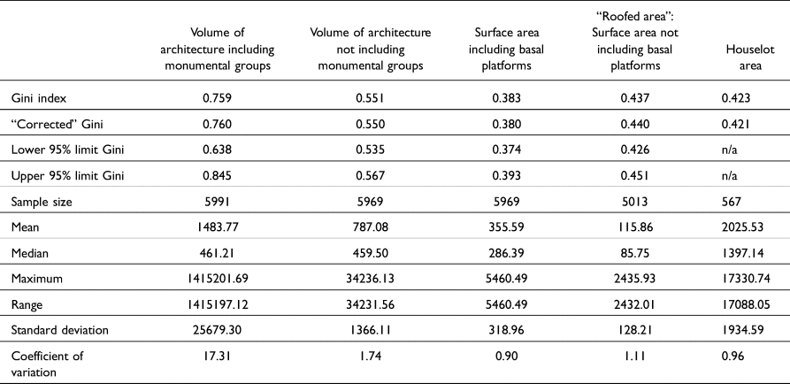
We used the methods outlined in Chase and colleagues (2023) to calculate Gini coefficients for architectural volume, roofed area (surface area of foundation braces and structures), total surface area of architecture, including unroofed basal platforms, and, for those 567 residential groups encircled by houselot walls, houselot area.
Results
In our introduction we posited that extreme inequality in urban settings can be dysfunctional, yet differences in wealth attract people to cities. Coba's Gini coefficient for volume of architecture, including monumental groups, is extreme—0.759—and exceeds the degree of inequality in nearly all cities and societies, both modern and ancient, that have Gini coefficients (Kohler et al. Reference Kohler, Smith, Bogaard, Peterson, Betzenhauer, Feinman, Oka, Pailes, Prentiss, Stone, Dennehy, Ellyson, Kohler and Smith2018; Kurtzleben Reference Kurtzleben2011; Shenk et al. Reference Shenk, Mulder, Beise, Clark, Irons, Leonetti, Low, Bowles, Hertz, Bell and Piraino2010; United Nations Human Settlement Programme 2010). Yet including the volume of monumental groups (which consist of both public and residential buildings) skews the sample (Basri and Lawrence Reference Basri and Lawrence2020). Removing the 22 monumental groups yields a volume Gini coefficient of 0.551. The Gini coefficients for total surface area of architecture, roofed area, and houselot space are 0.383, 0.437, and 0.423, respectively (see Table 2). These levels of inequality are substantial, but do not strike us as pathological; they fit well within the range of many ancient and modern state-level cities and societies (Kohler et al. Reference Kohler, Smith, Bogaard, Peterson, Betzenhauer, Feinman, Oka, Pailes, Prentiss, Stone, Dennehy, Ellyson, Kohler and Smith2018) and other Mesoamerican centers (Thompson et al. Reference Thompson, Feinman and Prufer2021:Table 5).
Table 2. Gini coefficients, confidence intervals, and summary statistics for wealth measurements at Coba.
Comparing these coefficients to those from Northern Lowland cities such as Chunchucmil and Dzibilchaltun (see Figure 1) illuminates the potential relationship between governance and wealth inequality. We do not subscribe to a dichotomous view in which governing structures are either autocratic or democratic. There is a continuum between these poles and room for other variables. In the ethnographic record and among contemporary nations, less democratic regimes tend to be more unequal (Ember et al. Reference Ember, Ember, Russett and Midlarsky1997; Savoia et al. Reference Savoia, Easaw and McKay2010). Kohler and colleagues (2018) argue that this pattern holds for ancient Mesoamerican settlements, yet some of the Gini coefficients in their comparison have since been revised (for example, Teotihuacan; Thompson et al. Reference Thompson, Feinman and Prufer2021), others are not directly comparable (Chase Reference Chase, Marken and Charlotte Arnauld2023), and certain variables, such as site size, geography, and chronology, were not controlled.
Chunchucmil is a good example of a less autocratic government, given its market economy, lack of strong evidence for dynastic rulership, and presence of over a dozen monumental compounds linked by causeways that perhaps housed leadership factions (Ardren Reference Ardren2015; Dahlin Reference Dahlin2009). Dzibilchaltun is a good example of a more autocratic regime: it has clear evidence of monarchy and clear clustering of monumental architecture at the site core (Maldonado Cárdenas Reference Maldonado Cárdenas, Lowe and Pérez2016). Coba, like Caracol (Chase Reference Chase2017, Reference Chase2021), may fall in between autocracy and democracy: it had dynastic rulership, but two distinct monumental centers (Nohoch Mul and Iglesias), as well as an extensive causeway system linking other monumental compounds (Figures 2 and 5). Importantly, the three sites provide a controlled comparison in that they are all very large, densely settled, northern plains cities, located between 20 and 30 km from the coast and roughly contemporaneous with peaks in the sixth through the eighth centuries. We desire a larger sample size, but due to a lack of settlement survey or modern site destruction, data are simply not available for the other large Northern Lowlands cities (e.g., Tiho/Mérida, Izamal, Uxmal, and Chichen Itza). Table 3 shows that the Gini coefficients for roofed house area for these three sites are all relatively similar, ranging from 0.43 (Coba) to 0.39 (Dzibilchaltun; incidentally, Teotihuacan, as reported by Thompson et al. Reference Thompson, Feinman and Prufer2021, falls in the middle of this range), implying that wealth inequality based on house size alone does not strictly parallel forms of governance. Palenque, an exemplary Late Classic autocratic regime, has slightly higher Gini coefficients for volume (0.63) and surface area (0.44), but Palenque is a significantly smaller site. The Late Classic Northern Lowland site of Sayil is also a significantly smaller city and has appreciably higher Gini coefficients (Table 3). Initial comparisons within this Compact Special Section (Chase et al. Reference Chase, Thompson, Walden and Feinman2023) suggest that larger site size does not possess a robust relationship with higher inequality.
Table 3. Comparative Gini data for the Northern Lowlands. Coefficients from Chunchucmil, Dzibilchaltun, and Sayil (estimated labor) are reported in Hutson Reference Hutson2016:156. Coefficients from Komchen and Sayil (roofed area) are reported in Brown and colleagues 2012.
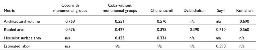
Mirroring an early argument by Rathje and McGuire (Reference Rathje and McGuire1982), Brown and colleagues (Brown et al. Reference Brown, Watson, Gravlin-Beman, Liebovitch and Braswell2012; Strawinska-Zanko et al. Reference Strawinska-Zanko, Liebovitch, Watson, Brown, Strawinska-Zanko and Liebovitch2018) suggested a relationship between inequality and chronology, with Gini coefficients increasing toward the end of the Classic period and falling in the Postclassic at sites like Mayapan. They note that increasing inequality may have been one of the pathologies that led to drastic reorganization of economic, social, and political institutions at the end of the Classic period. Yet they find an unexpectedly high Gini coefficient for architectural surface area from Late Preclassic Komchen, a Northern Lowland site near Dzibilchaltun. The dataset from Komchen is equivocal given that it includes a mix of actual houses (buildings in the range of 20–50 m2) and large basal platforms that supported houses but also contained substantial quantities of unroofed space. In our sample, Chunchucmil peaked first, then Coba, then Dzibilchaltun, but we do not find a trend of higher Gini coefficients over time.
The Lorenz curves for Coba reveal no clear breaks (Figures 6a and 6b). Lorenz curves plot cumulative population on the X axis and cumulative wealth proxies on the y axis. The lack of clear breaks also holds for other large Maya cities, such as Chunchucmil (Hutson Reference Hutson, Hutson and Ardren2020) and Caracol (Chase Reference Chase2021). The lack of clear breaks (also manifested in f'' graphs) suggests that the residential groups cannot be subdivided into clear-cut wealth categories or what we would refer to today as socioeconomic classes. These data therefore support what Mayanists have noticed for at least 30 years: continuous variation between the richest and poorest households (Chase and Chase Reference Chase, Chase, Chase and Chase1992; Sharer Reference Sharer, Sabloff and Henderson1993). In other words, differences in wealth from one household to the next are very gradual and seamless, up and down the spectrum. While some may argue that clear status distinctions (between “elites” and “commoners”) can exist alongside continuous variation in wealth, archaeological data indicate that status is also continuous as opposed to dichotomous (Hutson Reference Hutson, Hutson and Ardren2020).

Figure 6. (a) Lorenz curve for Coba roofed area and (b) architectural volume; (c) lognormal histogram for Coba roofed area and (d) architectural volume.
Finally, the histograms of the natural logarithm of the variates from Coba visually exhibit normal distributions (Figures 6c and 6d), which is also the case at Chunchucmil and Caracol (Chase Reference Chase2021:241). Although further calculations would be necessary to confirm a lognormal wealth distribution, this preliminary finding is intriguing, given that Strawinska-Zanko and colleagues (2018) find Pareto distributions at Sayil, Mayapan, and Palenque. Since Pareto distributions characterize inequality in recent societies, finding them in the past suggests basic similarities across millennia (see also Ortman et al. Reference Ortman, Cabaniss, Sturm and Bettencourt2014). The lognormal distributions of structure surface area and architectural volume at sites like Coba, Chunchucmil, and Caracol challenge this notion of basic similarities.
Conclusion
Gini coefficients for residential groups at Coba for roofed surface area, volume of architecture, and houselot space range from 0.423 to 0.551. Such values are not out of line with modern urban centers and indicate an appreciable, though by no means startling, degree of inequality. Such inequality stimulates urban processes that make cities both attractive and notorious. When we include monumental complexes with residences as well as massive structures that may not have been residential, such as temple pyramids, the Gini coefficients shoot upward.
The Gini values without the 22 monumental groups are relatively similar to those of other large, Classic period, Northern Lowland cities, such as Dzibilchaltun and Chunchucmil. It is tempting to suggest that comparable coefficients at a number of sites in the Northern Lowlands indicate shared patterns of urbanism and a shared understanding of how urban life was constituted, at least in the Classic period. Although the Gini coefficients from Sayil are higher, Sayil is also a much smaller site, situated in a very different topography—the Puuc Hills. The parallels between Coba, Chunchucmil, and Dzibilchaltun in terms of geography are also a striking indication of persistent Maya patterns of urban settlement at the edges of ecological zones, where residents had opportunities to take advantage of both coastal and inland resources. At the same time, Coba has perennial lakes and gets substantially more rain than Dzibilchaltun and Chunchucmil, so economies likely differed.
These data do not support the idea that autocratic regimes exhibit greater wealth inequality. Political authority at Chunchucmil was more distributed than at Dzibilchaltun, while Coba might be intermediate between the two, yet Gini values for Chunchucmil are not substantially lower than the other two sites. We also failed to find a pattern in which inequality grew over the course of the Classic period. The Lorenz curves for Coba and other sites do not indicate any breaks that would allow households to be sorted into wealth classes. Furthermore, wealthier households were spatially interspersed among less wealthy households (Hutson Reference Hutson2016). Thus, wealth differences were fluid, continuous, and out in the open, giving these settlements the dynamism and attractiveness that helped them grow into some of the largest and most remarkable ancient Maya cities.
Acknowledgments
We thank the Consejo de Arqueología of the Instituto Nacional de Antropología e Historia for granting the permits to conduct this research; all data are cultural patrimony of Mexico. We thank the communities of Coba, Nuevo Xcan, San Juan, San Pedro, and Yaxunah for allowing us to conduct research in their ejidos. We also appreciate the support and guidance of María José Con Uribe, José Manuel Ochoa Rodríguez, Adriana Velázquez, and Fernando Robles Castellanos in our efforts to work at Coba.
Competing interests declaration
The authors have no competing interests to declare.
Data availability statement
Releasing the locations of ancient residences risks encouraging the destruction of the archaeological record. Non-georeferenced raw data may be made available upon request to the authors.
Funding statement
This research was generously supported by the National Science Foundation (#1623603).


 Open access